Gascoyne River
| Gascoyne River | |
|---|---|
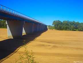 The Gascoyne riverbed near Carnarvon | |
| Origin | Three Rivers Station near Collier Range |
| Mouth | Shark Bay, Indian Ocean |
| Basin countries | Australia |
| Length | 865 kilometres (537 mi) |
| Source elevation | 514 metres (1,686 ft)[1] |
| Basin area | 76,254 square kilometres (29,442 sq mi)[2] |
The Gascoyne River is a river in the Gascoyne region of Western Australia. At 865 kilometres (537 mi), it is the longest river in Western Australia.[3]
Route
The river rises as the Gascoyne River (North Branch) on Three Rivers Station near the Great Northern Highway, 100 kilometres (62 mi) northeast of Peak Hill, and flows into Shark Bay and the Indian Ocean at Carnarvon.[4] It is joined by the 561 kilometres (349 mi) long Lyons River about 160 kilometres (99 mi) above its mouth which together provide a catchment area of 68,326 square kilometres (26,381 sq mi). This area lies entirely to the east of the Kennedy Ranges and extends some 480 kilometres (298 mi) inland.
The river is made up of three branches:
- The Gascoyne River Middle, is the middle 15 kilometres (9 mi) branch.
- The Gascoyne River North, is the northern 125 kilometres (78 mi) branch, which rises near the Collier Range.
- The Gascoyne River South, is the southern 15 kilometres (9 mi) branch, which rises near Doolgunna homestead.[4]
The Gascoyne has 36 tributaries including Landor River, Thomas River, Thirty one River, Coodewa Creek, Nanular Creek, Cream Creek, Moorayana Creek, Shay Creek, Turner Creek and Jacobs Gully.
It is said to be an upside-down river, as it flows for about 120 days of the year and below the dry river bed for the remainder of the year. It is in effect a huge water storage system with the river's aquifers lying below the desert sands.
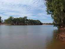
It flows through sparsely vegetated countryside which is used mainly for gold-mining and sheep stations. The river flows through many permanent pools that are valuable to both stock and native species. Some of the main pools located along the river include Tibbingoona Pool, Mutherbokin Pool and Mibbley Pool.
History
The river was discovered on 4 March 1839 by the explorer Lieutenant George Grey, who named it after a friend, Captain John Gascoyne RN,[5] son of Bamber Gascoyne, a Lord Commissioner of the Admiralty. Captain Gascoyne was a committee member of the London-based Western Australian Missionary Society and a member of the London Association for the Protection of the Interests of the Colony.[6]
The area had three dry years from mid 1909 to early 1913 with the Gascoyne River not running for any of that time. Carnarvon had water supply issues as a result of the lack of flow.[7]
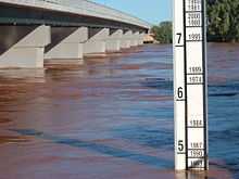
December 2010 floods
The December 2010 floods have been considered the most damaging flood on record [8] The size of the flood, and the region it affected has also created serious issues for the region [9]
Notes
- ↑ "Bonzle Digital Atlas - Map of Gascoyne River, WA". 2008. Retrieved 24 November 2008.
- ↑ Tille, Peter (Dec 2006). "Soil-landscapes of Western Australia’s Rangelands and Arid Interior" (pdf). Resource Management Technical Report (313): 13. Retrieved 9 May 2012.
- ↑ "Interesting facts about Western Australia". Landgate. Western Australian Land Information Authority. Retrieved 6 May 2012.
- ↑ 4.0 4.1 "History of River Names". Landgate. Western Australian Land Information Authority. Retrieved 9 May 2012.
- ↑ Grey, George (1841). Journals of two expeditions of discovery in North-West and Western Australia, during the years 1837, 38, and 39, describing many newly discovered, important, and fertile districts, with observations on the moral and physical condition of the aboriginal inhabitants, etc. etc. 1. London: T. and W. Boone. p. 349. Retrieved 2012-03-17.
- ↑ "From a private correspondent". The Perth Gazette and Western Australian Journal. 2 July 1836. pp. 720–721. Retrieved 9 May 2012.
- ↑ "River past Doorawarrah". Northern Times (Carnarvon, Western Australia: National Library of Australia). 1 February 1913. p. 5. Retrieved 17 December 2013.
- ↑ http://www.abc.net.au/news/stories/2010/12/21/3098255.htm
- ↑ http://www.abc.net.au/news/stories/2010/12/21/3098644.htm
Coordinates: 24°52′S 113°38′E / 24.867°S 113.633°E