Garhi Habibullah
| Garhi Habibullah گڑھی حبیب اللہ | |
|---|---|
| Union council and town | |
| Coordinates: 34°24′05″N 73°22′49″E / 34.4014°N 73.3803°E | |
| Country | Pakistan |
| Region | Khyber-Pakhtunkhwa |
| District | Mansehra District |
| Time zone | PST (UTC+5) |
| Area code(s) | 0997 |
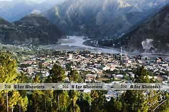
Garhi Habibullah is a town and union council (an administrative subdivision) of Mansehra District in the Khyber-Pakhtunkhwa province of Pakistan.[1] It is located in Mansehra Tehsil and lies to the east of the district capital Mansehra, towards the Kashmir frontier (near to Muzaffarabad the capital of Azad Kashmir). It is in an area affected by the 2005 Kashmir earthquake.[2]
History
In 997 CE, Sultan Mahmud Ghaznavi, took over the Ghaznavid dynasty empire established by his father, Sultan Sebuktegin, In 1005 he conquered the Shahis in Kabul in 1005, and followed it by the conquests of Punjab region. The Delhi Sultanate and later Mughal Empire ruled the region. The Pakhtunkhwa region became predominantly Muslim due to missionary Sufi saints whose dargahs dot the landscape of Khyber-Pakhtunkhwa.
After the decline of the Mughal Empire, the Sikh Empire invaded and occupied Mansehra District. The Muslims faced restrictions during the Sikh rule. During the period of British rule, Mansehra District increased in population and importance.
The predominantly Muslim population supported Muslim League and Pakistan Movement. After the independence of Pakistan in 1947, the minority Hindus and Sikhs migrated to India.
Garhi Habibullah is stronghold of Swatis, Habibullah who betrayed Syed Ahmed Shaeed and as a reward he got fort of Garhi with his name Habibullah. Sub-clans of Swatis in Garhi Habibullah are: Jahangeri, Arghushal, Serkheli, Aznali, Awan and Khankhel.
Villages around Garhi Habibullah
- Katha Dobandi
- Tanoli Mohallah Lower Katha Dobandi
- HASARI
- Guldhari
- Jageer
- Banda Balola
- Kashtra
- NARAL.
- Dogha
- Kurnool
- Bhuraj
- Butsingh
- Shamori
- Dumkatcha
- Upper & Lower Palyani.
References
| ||||||||||||
Coordinates: 34°24′N 73°23′E / 34.400°N 73.383°E