Garden Club of America Entrance Markers in Washington, D.C.
|
Garden Club of America Entrance Markers in Washington, D.C. MPS | |
 | |
|
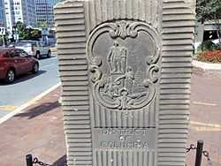
Cartouche of the District of Columbia | |
| Architect | Edward W. Donn, Jr. |
|---|---|
| Architectural style | Late 19th and early 20th Century Movements |
| Governing body | Local |
| NRHP Reference # | 64501007[1] |
The Garden Club of America Entrance Markers in Washington, D.C. is a Multiple Property Submission, or MPS, on the National Register of Historic Places. The seven structures that make up the MPS are ceremonial markers at important entrance points to the District of Columbia from the state of Maryland. Sets of two markers are located in Chevy Chase Circle along Connecticut Avenue and in Westmoreland Circle along Massachusetts Avenue.[2] Another pair flank Wisconsin Avenue NW in Friendship Heights.[3] A single marker is located along Georgia Avenue NW.[2] They were erected in 1932-1933 as a part of the George Washington bicentennial celebration.[4] Other events that commemorated the observance include the formal openings of the Arlington Memorial Bridge and the George Washington Memorial Parkway. There were further plans to create other entrance pylons into the city and a north portal at 16th Street Northwest, but they were never carried out (although in 2011 a boundary marker stood in a traffic circle in Silver Spring where the D.C/Maryland boundary crosses 16th Street).[5] The markers were designed by architect Edward Donn. The design was based on the markers of the Mason-Dixon Line that were installed in 1761 on the Pennsylvania and Maryland boundary.[6] They are composed of Aquia Creek sandstone and bear the Seal of Maryland on one side and the Cartouche of the District of Columbia on the opposite side. The cartouche depicts George Washington with Lady Justice, a laurel wreath, the rising sun and the capitol dome.
List of the Markers
| Name | Image | Address | Location | Neighborhood | Designation | Ref. Number |
| Garden Club of America Entrance Markers at Chevy Chase Circle | 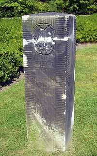 |
Reservation 335A | 38°58′3″N 77°4′37″W / 38.96750°N 77.07694°W | Chevy Chase Circle | April 29, 2008 | 08000346 |
| Garden Club of America Entrance Marker at Georgia Avenue |  |
Georgia Ave. at Kalmia Rd. & Alaska Ave. | 38°59′02″N 77°01′36″W / 38.9839102°N 77.0267349°W | Shepherd Park | April 29, 2008 | 08000347 |
| Garden Club of America Entrance Markers at Westmoreland Circle | 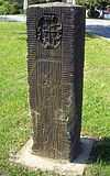 |
Reservation 559 | 38°56′56.11″N 77°6′3.28″W / 38.9489194°N 77.1009111°W | Westmoreland Circle | April 29, 2008 | 08000348 |
| Garden Club of America Entrance Markers at Wisconsin Avenue |  |
Wisconsin Ave. at Western Ave. | 38°57′38.94″N 77°5′8.48″W / 38.9608167°N 77.0856889°W | Friendship Heights | May 12, 2008 | 08000394 |
See also
References
- ↑ "National Register Information System". National Register of Historic Places. National Park Service. 2009-03-13.
- ↑ 2.0 2.1 "WEEKLY LIST OF ACTIONS TAKEN ON PROPERTIES: 4/28/08 THROUGH 5/02/08". National Register of Historic Places. National Park Service. 2011-05-09. Archived from the original on 2012-04-24. Retrieved 2012-04-24.
- ↑ "WEEKLY LIST OF ACTIONS TAKEN ON PROPERTIES: 5/12/08 THROUGH 5/16/08". National Register of Historic Places. National Park Service. 2011-05-23. Archived from the original on 2012-04-26. Retrieved 2012-04-24.
- ↑ "Garden Club Entrance Markers". District of Columbia Inventory of Historic Sites: Alphabetic Version. District of Columbia Historic Preservation Office. 2009-09-30. Archived from the original on 2012-04-26. Retrieved 2012-04-26.
- ↑ Farragutfull (2011-12-04). "DC Boundary Marker at SS traffic circle". Wikimedia Commons. Archived from the original on 2012-04-26. Retrieved 2012-04-26.
- ↑ Myra Mensh Patner (2001-04-11). "Return of the sandstone pylons". Gazette.net. Retrieved 2011-11-01.