Garcia, Colorado
| Garcia, Colorado | |
|---|---|
| Unincorporated community | |
| Coordinates: 37°00′12″N 105°32′12″W / 37.00333°N 105.53667°WCoordinates: 37°00′12″N 105°32′12″W / 37.00333°N 105.53667°W | |
| Country |
|
| State |
|
| Counties | Costilla[2] |
| Elevation[2] | 7,726 ft (2,355 m) |
| Time zone | MST (UTC-7) |
| • Summer (DST) | MDT (UTC-6) |
| ZIP code[3] | 81152 |
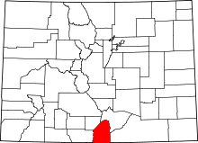
Garcia is an unincorporated community and a U.S. Post Office located in Costilla County, Colorado, United States, just north of the New Mexico border. The Garcia Post Office has the ZIP Code 81134.[3] Garcia has a bar/restaurant owned by Theresa Cordova, known as Moe's Place. Garcia has a Baptist Church and a Catholic church.
History
This was the first area of Colorado to be colonized, with written history dating to 1540. In 1849, Garcia was established and the name was permanently changed when the village got a post office. It is also known as Los Garcia. Settlement was also aided that year when a treaty was signed with the Utes. In 2009, Garcia had a population of 276 people. Since 2000, the population has decreased by almost 3 percent.
Geography
Garcia is located at 37°00′12″N 105°32′12″W / 37.00333°N 105.53667°W (37.003375,-105.536728).
References
- ↑ http://www.blm.gov/pgdata/etc/medialib/blm/wo/Planning_and_Renewable_Resources/coop_agencies/new_documents/co1.Par.35086.File.dat/athearn_forgotten.pdf
- ↑ 2.0 2.1 "US Board on Geographic Names". United States Geological Survey. 2007-10-25. Retrieved 2008-01-31.
- ↑ 3.0 3.1 "ZIP Code Lookup" (JavaScript/HTML). United States Postal Service. December 15, 2006. Retrieved December 15, 2006.
| |||||||||||||||||||||
