Garafía
| Garafía | |||
|---|---|---|---|
| Municipality | |||
| |||
 | |||
 Garafía Location in Canary Islands | |||
| Coordinates: 28°49′N 17°55′W / 28.817°N 17.917°WCoordinates: 28°49′N 17°55′W / 28.817°N 17.917°W | |||
| Country |
| ||
| Autonomous community |
| ||
| Province |
| ||
| Island |
| ||
| Area[1] | |||
| • Total | 103.00 km2 (39.77 sq mi) | ||
| Elevation[1] | 400 m (1,300 ft) | ||
| Population (2009)[2] | |||
| • Total | 1,804 | ||
| • Density | 18/km2 (45/sq mi) | ||


Garafía is a municipality in the Canary Islands in the province of Santa Cruz de Tenerife. It is situated on the northern coast of the island of La Palma. The capital of the municipality is Santo Domingo. Other villages are Las Tricias, El Castillo, Juan Adalid, Don Pedro, El Tablado, La Mata, San Antonio del Monte and Franceses. The elevation ranges from 0 at the coast to 2423m at the Roque de los Muchachos.
Until the 1960s the villages were largely isolated from the rest of the island and only accessible by donkey paths. Since then roads have been built and the area is easily accessible on good, but twisty, asphalted roads. As with many rural areas the population is in decline as small scale agriculture and traditional rural life does not provide the income to encourage young people to stay.
It is however the most wonderful area for walking and hiking with its network of marked walking paths, lush greenery and spectacular scenery. The steep forested hillside are dissected by barrancos (gorges).
The higher parts of Garafía are covered in pine trees with just a small treeless area above the tree line. The central areas around the villages are mostly farmland or rough natural landscape including almond trees and vineyards. The coastline is rough with steep cliffs and gorges and can be accessed at several points.
The highest point of the municipality, Roque de los Muchachos, is the highest point of the island. It is on the edge of the Caldera de Taburiente National Park which is the largest erosion crater in the world. The highest point is accessible by asphalted road from both the east and the west side and has several viewing points giving views inside the Caldera and over almost the entire island and often to the neighbouring islands of Tenerife, La Gomera and El Hierro. Roque de los Muchachos hosts the Roque de los Muchachos Observatory, run by the IAC and international collaborators.
Historical population
| Year | Population |
|---|---|
| 1991 | 2,013 |
| 1996 | 2,002 |
| 2001 | 1,795 |
| 2002 | 2,002 |
| 2003 | 1,998 |
| 2004 | 1,948 |
| 2009 | 1,804 |
| 2013 | 1,645 |
Gallery
-
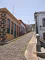
Santo Domingo - seat of Garafía
-
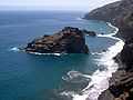
Hiscaguán, the north coast of La Palma
-
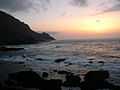
Hiscaguán, the north coast of La Palma
See also
References
- ↑ 1.0 1.1 "SUPERFICIE, PERÍMETRO Y ALTITUD DE LOS MUNICIPIOS DE CANARIAS." (in Spanish). Instituto Canario de Estadística (ISTAC).
- ↑ "Población en Canarias. La Palma. 1-1-2009" (in Spanish). Instituto Canario de Estadística (ISTAC).
 |
Atlantic Ocean | | ||
| |
Barlovento | |||
| ||||
| | ||||
| Puntagorda | El Paso |
| ||||||||||||||||||||