Garabogazköl
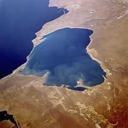


The Garabogazköl Aylagy, alternatively the Kara-Bogaz-Gol (Turkmen: black strait lake) is a shallow inundated depression in the northwestern corner of Turkmenistan. It forms a lagoon of the Caspian Sea with a surface area of about 18,000 km2 (6,900 sq mi). It is separated from the Caspian Sea proper, which lies immediately to the west, by a narrow, rocky ridge having a very narrow opening in the rock through which the Caspian waters flow, cascading down into Garabogazköl (whence the name of the bay – "Mighty Strait Lake" in the Turkmen language – comes). The water volume of the bay fluctuates seasonally with the Caspian Sea; at times it becomes a large bay of the Caspian Sea, while at other times its water level drops drastically.
The city of Garabogaz (formerly Bekdaş) lies on the ridge, about 50 km (31 mi) north of the channel between the main Caspian basin and the Garabogazköl lagoon. The town has a population of about 10,000.
Salt
The salinity of the bay is about 35%, compared to the Caspian Sea's 1.2% and 3.5% for the world's oceans. Because of the exceptionally high salinity it has practically no marine vegetation. Large evaporite, mostly salt deposits accumulated at the south shore were harvested by the local population since the 1920s, but in the 1930s manual collection stopped and the industry shifted northwest to its present center near Garabogaz. From the 1950s on, ground water was pumped from levels lower than the bay itself, yielding more valuable types of salts. In 1963 construction began at Garabogaz on a modern plant for increased production of salines, all the year round and independently of natural evaporation. This plant was completed in 1973.
In March 1980, the barrier to the Caspian was blocked, due to concerns evaporation was accelerating a fall in Caspian Sea level, reducing water levels. The resulting "salt bowl" caused widespread problems of blowing salt,[1] reportedly poisoning the soil and causing health problems for hundreds of kilometers downwind to the east. In 1984 the lake was completely dry, as can be seen in NASA photos. In June 1992, when Caspian Sea levels were rising again, the barrier was breached, allowing Caspian water to again refill Garabogazköl. The remnants of the breached dam can be seen in the satellite photo to the right near the Caspian Sea entrance.
Miscellaneous
The bay is also the subject of Konstantin Georgiyevich Paustovsky's 1932 book Kara-Bogaz.
References
- ↑ Micklin, Philip P. Environmental Resources and Constraints in the Former Soviet Republics (1994). The National Council for Soviet and Eastern European Research. Page 9.
External links
Coordinates: 41°21′07″N 53°35′43″E / 41.35194°N 53.59528°E