Gairdner River
| Gairdner River | |
|---|---|
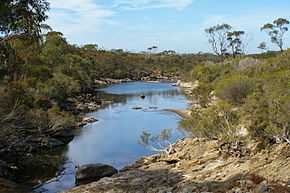 Gairdner River near West Mount Barren | |
| Origin | Needilup-Jacup |
| Mouth | Gordon Inlet |
| Basin countries | Australia |
| Length | 130 kilometres (81 mi) |
| Source elevation | 320 metres (1,050 ft)[1] |
| Avg. discharge | 940,000 ML/year [2] |
| Basin area | 1,770 square kilometres (683 sq mi) |
Gairdner River is a river located in the Great Southern region of Western Australia. The river was first recorded by Surveyor General John Septimus Roe in 1848, when carrying out exploration of the area, noting that natives referred to it and its numerous branches as "Jeer-A-Mung-Up". Roe named the river after Gordon Gairdner, Senior Clerk of the Australian and Eastern Departments in the Colonial Office, later Chief Clerk of the Colonial Office and Secretary and Registrar of the Most Distinguished Order of Saint Michael and Saint George.[3] Roe also named Gordon Inlet and Mount Gordon after Gairdner.[4]
The river originates in farm land north of the South Coastal Highway between Needilup and Jacup on the Yilgarn plateau about 320 metres (1,050 ft) sea level. It flows in a south-easterly direction crossing the South Coast Highway east of Jerramungup then through the Fitzgerald River National Park until it terminates in Gordon Inlet, where it discharges an average of 9,400,000 cubic metres per annum.
The tributaries that flow into the river are Cobomup Creek, Needilup River, Pingamup River, Spring Creek, Wilgerup Creek, Scott Creek and Duleep Creek.
About 60% of the catchment has been cleared for sheep and grains farming and as a result the water quality has become saline. Salinity levels vary from 3‰ after rains when the river is flowing to 50‰ during the summer time.
There is another Gairdner River in Western Australia, located in the Kimberley region, also named after Gordon Gairdner. This Gairdner River is located in the west Kimberley, and is a 42km long tributary of the Glenelg River. It was named in 1838 by Lieutenants George Grey and Franklin Lushington, on Grey's first disastrous exploratory expedition along the Western Australian coast.[5][6]
References
- ↑ "Bonzle Digital Atlas - Map of Gairdner River, WA". 2008. Retrieved 24 November 2008.
- ↑ "South Coast Rivercare - Gairdner River". 2007. Retrieved 25 May 2010.
- ↑ "Colonial Office, Downing Street, May 28, 1874." (pdf). The London Gazette (24099): 2820. 29 May 1874. Retrieved 2012-03-28.
- ↑ Western Australian Land Information Authority. "History of river names". Retrieved 5 September 2011.
- ↑ "Arts and Sciences - Royal Geographical Society". The literary gazette and journal of belles lettres, arts, sciences, etc (1139): 731–732. 1838-11-17.
- ↑ Grey, George (1841). Journals of two expeditions of discovery in North-West and Western Australia, during the years 1837, 38, and 39, describing many newly discovered, important, and fertile districts, with observations on the moral and physical condition of the aboriginal inhabitants, etc. etc. 1. London: T. and W. Boone. Retrieved 17 March 2012.
Coordinates: 34°15′51.45″S 119°24′12.74″E / 34.2642917°S 119.4035389°E