Gainesville, Alabama
| Gainesville, Alabama | |
|---|---|
| Town | |
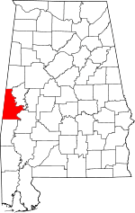
 Location in Sumter County and the state of Alabama | |
| Coordinates: 32°49′2″N 88°9′28″W / 32.81722°N 88.15778°W | |
| Country | United States |
| State | Alabama |
| County | Sumter |
| Area | |
| • Total | 1.7 sq mi (4.4 km2) |
| • Land | 1.7 sq mi (4.4 km2) |
| • Water | 0 sq mi (0 km2) |
| Elevation | 128 ft (39 m) |
| Population (2000) | |
| • Total | 220 |
| • Density | 129.4/sq mi (50/km2) |
| Time zone | Central (CST) (UTC-6) |
| • Summer (DST) | CDT (UTC-5) |
| ZIP code | 35464 |
| Area code(s) | 205 |
| FIPS code | 01-28768 |
| GNIS feature ID | 0157962 |
| Website | http://townofgainesvillealabama.com/ |
Gainesville is a town in Sumter County, Alabama, United States. At the 2000 census the population was 220. Confederate Lieutenant General Nathan Bedford Forrest surrendered near Gainesville on May 9, 1865.
Geography
Gainesville is located at 32°49′2″N 88°9′29″W / 32.81722°N 88.15806°W (32.817317, -88.158026).[1]
According to the U.S. Census Bureau, the town has a total area of 1.7 square miles (4.4 km2), all of it land.
Demographics
| Historical population | |||
|---|---|---|---|
| Census | Pop. | %± | |
| 1880 | 960 | — | |
| 1890 | 1,017 | 5.9% | |
| 1900 | 817 | −19.7% | |
| 1910 | 532 | −34.9% | |
| 1920 | 355 | −33.3% | |
| 1930 | 329 | −7.3% | |
| 1940 | 283 | −14.0% | |
| 1950 | 319 | 12.7% | |
| 1960 | 214 | −32.9% | |
| 1970 | 255 | 19.2% | |
| 1980 | 207 | −18.8% | |
| 1990 | 449 | 116.9% | |
| 2000 | 220 | −51.0% | |
| 2010 | 208 | −5.5% | |
| Est. 2013 | 201 | −3.4% | |
| U.S. Decennial Census[2] 2013 Estimate[3] | |||
As of the census[4] of 2000, there were 220 people, 87 households, and 58 families residing in the town. The population density was 128.3 people per square mile (49.7/km²). There were 122 housing units at an average density of 71.1 per square mile (27.5/km²). The racial makeup of the town was 22.73% White and 77.27% Black or African American.

There were 87 households out of which 29.9% had children under the age of 18 living with them, 31.0% were married couples living together, 32.2% had a female householder with no husband present, and 33.3% were non-families. 33.3% of all households were made up of individuals and 16.1% had someone living alone who was 65 years of age or older. The average household size was 2.53 and the average family size was 3.28.
In the town the population was spread out with 32.3% under the age of 18, 9.1% from 18 to 24, 23.6% from 25 to 44, 14.5% from 45 to 64, and 20.5% who were 65 years of age or older. The median age was 37 years. For every 100 females there were 96.4 males. For every 100 females age 18 and over, there were 93.5 males.
The median income for a household in the town was $10,938, and the median income for a family was $13,750. Males had a median income of $25,625 versus $15,625 for females. The per capita income for the town was $16,176. About 60.4% of families and 70.1% of the population were below the poverty line, including 82.6% of those under the age of eighteen and 48.3% of those sixty five or over.
Points of interest

Gainesville has many historic sites that are listed on the National Register of Historic Places, with many that predate the American Civil War. The historic districts include the Gainesville Historic District and Main–Yankee Street Historic District. Individual structures include Aduston Hall, the Coffin Shop, Colgin Hill, Gibbs House, Col. Green G. Mobley House, the Park and Bandstand, and Laura Watson House.[5][6]
Notable native
- Buck Buchanan, former NFL player for the Kansas City Chiefs. He was inducted into the Pro Football Hall of Fame in 1990.
- Jaybird Coleman, country blues harmonica player, guitarist, and singer
- Maria Fearing, Presbyterian missionary. Inducted into the Alabama Women's Hall of Fame in 2000
References
- ↑ "US Gazetteer files: 2010, 2000, and 1990". United States Census Bureau. 2011-02-12. Retrieved 2011-04-23.
- ↑ "U.S. Decennial Census". Census.gov. Retrieved June 6, 2013.
- ↑ "Annual Estimates of the Resident Population: April 1, 2010 to July 1, 2013". Retrieved June 3, 2014.
- ↑ "American FactFinder". United States Census Bureau. Retrieved 2008-01-31.
- ↑ "National Register Information System". National Register of Historic Places. National Park Service. 2009-03-13.
- ↑ Gainesville MRA NRIS Database, National Register of Historic Places. Retrieved July 2, 2011.
External links
Coordinates: 32°49′02″N 88°09′29″W / 32.817317°N 88.158026°W
| |||||||||||||||||||||||||
