Gage Park, Chicago
| Gage Park | |
|---|---|
| Community area | |
| Community Area 63 - Gage Park | |
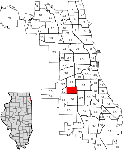 Location within the city of Chicago | |
| Coordinates: 41°47.4′N 87°41.4′W / 41.7900°N 87.6900°WCoordinates: 41°47.4′N 87°41.4′W / 41.7900°N 87.6900°W | |
| Country | United States |
| State | Illinois |
| County | Cook |
| City | Chicago |
| Neighborhoods |
list
|
| Area | |
| • Total | 2.24 sq mi (5.80 km2) |
| Population (2010) | |
| • Total | 39,894 |
| • Density | 18,000/sq mi (6,900/km2) |
| Demographics2010[1] | |
| • White | 4.74% |
| • Black | 5.42% |
| • Hispanic | 89.21% |
| • Asian | 0.3% |
| • Other | 0.33% |
| Time zone | CST (UTC-6) |
| • Summer (DST) | CDT (UTC-5) |
| ZIP Codes | parts of 60609, 60629, 60632 and 60636 |
| Median income | $36,463 |
| Source: U.S. Census, Record Information Services | |
Gage Park is one of Chicago's 77 well-defined community areas, located on the city's southwest side; it is also the name of a park within the neighborhood. Gage Park's population is largely working-class, and its housing stock is mostly bungalows. For generations, the neighborhood was Eastern European and Irish Catholic. The neighborhood remains overwhelmingly Catholic with the addition of many Hispanic residents.
Early history
The development of Gage Park began in 1873 when South Park Commissioner George W. Gage began working on a planned park at the intersection of Western Ave. and Garfield Boulevard. Upon Gage's death in 1875, the park was renamed Gage Park in his honor.
The area developed slowly after Gage's passing, slowly adding more and more land and offering up more services to the local community. By 1919, Gage Park had added more land and the park now included ball fields, tennis courts, separate men's and women's gymnasiums, gardens, and a wading pool. A large field house and auditorium was later added in 1928, with a large mural by Tom Lea added in 1931.
Education
Chicago Public Schools operates district public schools.
The United Neighborhood Organization operates the Rufino Tamayo School and the UNO Soccer Academy in Gage Park.[2]
| Historical population | |||
|---|---|---|---|
| Census | Pop. | %± | |
| 1930 | 31,535 | — | |
| 1940 | 30,343 | −3.8% | |
| 1950 | 30,149 | −0.6% | |
| 1960 | 28,244 | −6.3% | |
| 1970 | 26,698 | −5.5% | |
| 1980 | 24,445 | −8.4% | |
| 1990 | 26,957 | 10.3% | |
| 2000 | 39,193 | 45.4% | |
| 2010 | 39,894 | 1.8% | |
| [3] | |||
References
- ↑ Paral, Rob. "Chicago Demographics Data". Retrieved 21 September 2012.
- ↑ "UNO Charter Schools." United Neighborhood Organization. Retrieved on June 16, 2012.
- ↑ Paral, Rob. "Chicago Community Areas Historical Data". Retrieved 3 September 2012.
External links
| ||||||||||||||||||||||||||||||||||||||
 |
Archer Heights, Chicago | Brighton Park, Chicago | New City, Chicago | |
| West Elsdon, Chicago | |
|||
| ||||
| | ||||
| West Lawn, Chicago | Chicago Lawn, Chicago | West Englewood, Chicago |