Générac, Gard
| Générac | |
|---|---|
|
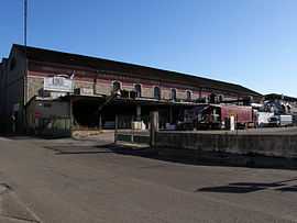
Cooperative winery | |
 Générac | |
|
Location within Languedoc-Roussillon region  Générac | |
| Coordinates: 43°43′45″N 4°20′58″E / 43.7292°N 4.3494°ECoordinates: 43°43′45″N 4°20′58″E / 43.7292°N 4.3494°E | |
| Country | France |
| Region | Languedoc-Roussillon |
| Department | Gard |
| Arrondissement | Nîmes |
| Canton | Saint-Gilles |
| Intercommunality | Nîmes Métropole |
| Government | |
| • Mayor (2008–2014) | Frédéric Touzellier |
| Area1 | 24.26 km2 (9.37 sq mi) |
| Population (2008)2 | 3,805 |
| • Density | 160/km2 (410/sq mi) |
| INSEE/Postal code | 30128 / 30510 |
| Elevation |
29–144 m (95–472 ft) (avg. 82 m or 269 ft) |
|
1 French Land Register data, which excludes lakes, ponds, glaciers > 1 km² (0.386 sq mi or 247 acres) and river estuaries. 2 Population without double counting: residents of multiple communes (e.g., students and military personnel) only counted once. | |
Générac is a commune in the Gard department in southern France.
Population
| Historical population | ||
|---|---|---|
| Year | Pop. | ±% |
| 1793 | 1,100 | — |
| 1800 | 1,183 | +7.5% |
| 1806 | 1,416 | +19.7% |
| 1821 | 1,740 | +22.9% |
| 1831 | 1,883 | +8.2% |
| 1836 | 1,904 | +1.1% |
| 1841 | 1,988 | +4.4% |
| 1846 | 1,930 | −2.9% |
| 1851 | 1,940 | +0.5% |
| 1856 | 2,084 | +7.4% |
| 1861 | 2,159 | +3.6% |
| 1866 | 2,287 | +5.9% |
| 1872 | 2,260 | −1.2% |
| 1876 | 2,207 | −2.3% |
| 1881 | 1,814 | −17.8% |
| 1886 | 1,848 | +1.9% |
| 1891 | 1,983 | +7.3% |
| 1896 | 1,945 | −1.9% |
| 1901 | 2,080 | +6.9% |
| 1906 | 2,112 | +1.5% |
| 1911 | 2,034 | −3.7% |
| 1921 | 1,886 | −7.3% |
| 1926 | 1,785 | −5.4% |
| 1931 | 2,030 | +13.7% |
| 1936 | 1,855 | −8.6% |
| 1946 | 1,630 | −12.1% |
| 1954 | 1,667 | +2.3% |
| 1962 | 1,650 | −1.0% |
| 1968 | 1,682 | +1.9% |
| 1975 | 1,764 | +4.9% |
| 1982 | 2,113 | +19.8% |
| 1990 | 2,925 | +38.4% |
| 1999 | 3,223 | +10.2% |
| 2008 | 3,805 | +18.1% |
See also
References
| Wikimedia Commons has media related to Générac (Gard). |