Fuxing District, Taoyuan
| Fuxing 復興區 | |
|---|---|
| Mountain Indigenous District | |
| Fuxing District | |
 | |
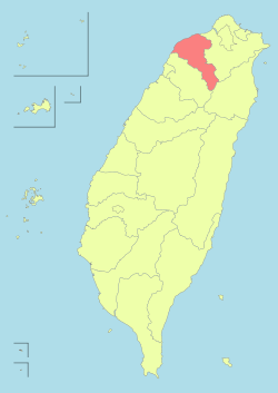
 Fuxing District in Taoyuan City | |
| Country |
|
| Municipality | Taoyuan City |
| Boroughs |
List
|
| Government | |
| • Type | District government |
| • District chief | Fan Cheng-hsin[1] (Ind.) |
| Population (December 2014) | |
| • Total | 10,913 |

Fuxing District (Chinese: 復興區; pinyin: Fùxīng Qū), formerly known as Fuxing Township or Fu-Hsing Township (Chinese: 復興鄉; Hanyu Pinyin: Fùxīng Xiāng; Tongyong Pinyin: Fùsing Siang; Wade–Giles: Fu4-hsing1 Hsiang1) is an aboriginal rural district in eastern Taoyuan City, Taiwan. Fuxing is home to many Atayal tribes. Lalashan (拉拉山) is a major feature of Fuxing, and the Shimen Reservoir, formed by Shimen Dam, is a popular nearby site. Fuxing District is, by area, the largest district in Taoyuan City.
Geography
- Area: 350.78 km²
- Population: 10,913 people (December 2014)
Administrative divisions
Sanmin Village, Zeren Village, Xiayun Village, Yicheng Village, Luofu Village, Zhangxing Village, Kuihui Village, Gaoyi Village, Sanguang Village, Hualing Village.[2]
Mountains over 1500 metres
- Najieshan 那結山, 1520 m
- Mawangzenglushan 馬望曾呂山, 1577 m
- Niaozuishan 鳥嘴山, 1749 m
- Jianshan 興尖山, 1852 m
- Fufushan 夫婦山, 1870 m
- Meiguiximoshan 玫瑰西魔山, 1871 m
- Lengshan 稜山, 1889 m
- Lupaishan 魯培山, 1905 m
- Nanchatianshan 南插天山, 1907 m
- Lidongshan 李棟山, 1914 m
- Lalashan 拉拉山, 2030 m
- Tangsuishan 唐穗山, 2090 m
- Babokulushan 巴博庫魯山, 2101 m
- Tamanshan 塔曼山, 2130 m
- Dilushan 低陸山, 2160 m
- Yufengshan 玉峰山, 2300 m
- Siqiusishan 西丘斯山, 2427 m
- Xuebaishan 白的山, 2444 m
Northern Cross-Island Highway Hiking Trails
- 12.1 km > Sanmin Bat Cave...
- 16.3 km > Jiaobanshan, Jinpingshan...
- 17.7 km > Dongyanshan, Zhijishan...
- 20.7 km > Xiao Wulai > Hewei Ancient Trees, Beichatianshan, Nanchatianshan, Lupaishan, Daishifushan...
- 22.7 km > Luofu > Roma Rd.
- 28.2 km > Dawan > Najieshan...
- 31.1 km > Xuewu Tunnel > Fufushan...
- 39.9 km > Gaoyi > Yingshan...
- 46.5 km > Baling Bridge.
- 47.4 km > Galahe > Xuebaishan, Tangsuishan, Dilushan, Yufengshan, Siqiusishan...
- 47.8 km > Shang Baling > Lalashan Ancient Trees, Tamanshan, Meiguiximoshan, Baling-Fushan Trail...
- 59.3 km > Jianshan...
- 61.5 km > Lengshan
- 67.0 km > Mingchi > Babokulushan...
River Tracing
- Yunei River
- Xibuqiao River
- Sanguang River
- Taman River
Parks
- Dongyanshan National Forest Recreation Area
- Chatianshan Nature Reserve
- Lalashan Forest Reserve
- Xiao Wulai Scenic Area
- Jiaobanshan Sculpture Park
- Sanmin Bat Cave
Transportation
Zhongli Bus Co.
- Taoyuan Station 桃園 06:30 – Linbankou 林班口開 09:30
- Taoyuan Station 桃園 12:30 - Linbankou 林班口開 15:30
Taoyuan Bus Co.
- Taoyuan Station 桃園 06:50 - Linbankou 林班口開 09:50
- Zhongli Station 中壢 10:30 - Linbankou 林班口開 13:30
See also
References
External links
| Wikimedia Commons has media related to Fusing, Taoyuan. |
| |||||||||||||||||
| |||||||||||||||||||||||||||||||||||||||||||||||||||||||||||||||||||||||||||||||||||||

Coordinates: 24°49′22.18″N 121°21′6.27″E / 24.8228278°N 121.3517417°E