Furry Creek, British Columbia
| Furry Creek | |
|---|---|
|
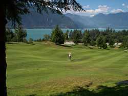
Golfing at Furry Creek | |
 Furry Creek Location of Furry Creek in British Columbia | |
| Coordinates: 49°35′00″N 123°12′40″W / 49.58333°N 123.21111°WCoordinates: 49°35′00″N 123°12′40″W / 49.58333°N 123.21111°W | |
| Country |
|
| Province |
|
| Area code(s) | 250, 778 |
Furry Creek is a community in the Canadian province of British Columbia, located on Howe Sound in the Squamish-Lillooet Regional District, north of Vancouver and south of Squamish. The creek was named in the 1870s after early prospector and settler Oliver Furry. Loggers worked the slopes, and a two adits from the Brittania Creek mine opened into Furry Creek where logging camp supplied timbers for shoring in the early 1900s. Dams on Phyliss and Marion Lake and Furry Creek redirected water from Furry Creek to the Britannia mine for power generation. Later in the century a gravel pit operated in the area. Cabins and borstal at nearby Porteau Cove made the area sparsely populated for many years, with some camping and little other activity except for the highway and railroad that cut through the bottom of the watershed.
Ribbon development along the Sea-to-Sky British Columbia Highway 99 is now infilling open areas like Furry Creek and Britannia Beach. Starting in 1991 with opening in 1993, the Furry Creek area saw significant changes with a golf course developed by Tanac Land Development, a Japanese concern, as well as luxury homes. Because its slopes are very steep and spread out nature of the links style course, golf carts are mandatory. Numerous films and commercials have been filed there, including parts of Happy Gilmore.
External links
| Wikimedia Commons has media related to Furry Creek, British Columbia. |
