Furna (Brava)
| Furna | |
|---|---|
| Settlement | |
|
Coast Road with a view to the church. | |
 Furna | |
| Coordinates: 14°53′13″N 24°40′48″W / 14.887°N 24.680°WCoordinates: 14°53′13″N 24°40′48″W / 14.887°N 24.680°W | |
| Country | Cape Verde |
| Island | Brava |
| Municipality | Brava |
| Civil parish | São João Baptista |
| Population (2010)[1] | |
| • Total | 612 |

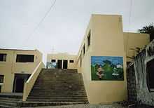
School with wall paintings

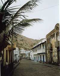
Main Street.
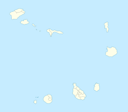
Furna is a seaside community in the northeastern part of the island of Brava, Cape Verde. It lies 2.5 km northeast of the island capital of Vila Nova Sintra.
Furna became the most important harbour of Brava in 1843.[2] In 1982, many boats and some houses of Furna were destroyed by waves reaching a height of up to 10 meters which were caused by the tropical storm Beryl.[3] The harbour was improved in 2000.[4]
The new yellow school near the small church in the South of the village, which was paid by the government of Belgium, has large wall paintings motivating the children to save as much water as possible and to help keeping the island green.
External links
References
- ↑ "2010 Census results". Instituto Nacional de Estatística Cabo Verde (in Portuguese). 17 March 2014.
- ↑ Reitmeier, Pitt: Cabo Verde, p.415. Bielefeld 2009.
- ↑ Osang, Rolf: Kapverdische Inseln, p.151. Cologne 2001.
- ↑ Lipps, Susanne: Kapverdische Inseln, p.270. Ostfildern 2009.
| ||||||||||||||
