Frederick County, Maryland
| Frederick County, Maryland | |||
|---|---|---|---|
 Downtown Frederick in June 2014 | |||
| |||
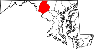 Location in the state of Maryland | |||
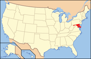 Maryland's location in the U.S. | |||
| Founded | June 10, 1748 | ||
| Seat | Frederick | ||
| Largest city | Frederick | ||
| Area | |||
| • Total | 667 sq mi (1,728 km2) | ||
| • Land | 660 sq mi (1,709 km2) | ||
| • Water | 7.2 sq mi (19 km2), 1.1% | ||
| Population (Est.) | |||
| • (2014) | 243,675 | ||
| • Density | 353/sq mi (136/km²) | ||
| Congressional districts | 6th, 8th | ||
| Time zone | Eastern: UTC-5/-4 | ||
| Website |
www | ||

Frederick County is a county located in the northern part of the U.S. state of Maryland. As of the 2010 U.S. Census, the population was 240,336.[1] The county seat is Frederick.[2]
Frederick County is included in the Washington-Arlington-Alexandria, DC-VA-MD-WV Metropolitan Statistical Area. As a result, the county has experienced a rapid population increase in recent years.[3][4] The county is sometimes associated with Western Maryland, depending on the definition used. It borders the southern border of Pennsylvania and the northeastern border of Virginia.
The county is home to Catoctin Mountain Park (encompassing the presidential retreat Camp David) and to the U.S. Army's Fort Detrick. It has also been the home to several celebrated historical figures like Francis Scott Key, Thomas Johnson, Roger B. Taney, and Barbara Fritchie.
Etymology
The exact namesake of Frederick County and its eponymous county seat is unknown, but they may have been named after either Frederick, Prince of Wales, or Frederick Calvert, 6th Baron Baltimore.[5]
History
Frederick County was created in 1748 from parts of Prince George's County and Baltimore County.
In 1776, Frederick County was divided into three parts. The westernmost portion became Washington County, named after George Washington, the southernmost portion became Montgomery County, named after another Revolutionary War general, Richard Montgomery. The northern portion remained Frederick County.
In 1837 a part of Frederick County was combined with a part of Baltimore County to form Carroll County which is east of current day Frederick County.
The county has a number of properties on the National Register of Historic Places.[6]
Law, government, and politics
Until 2014, Frederick County was governed by county commissioners, the traditional form of county government in the state of Maryland.
Charter government
Effective December 1, 2014, Frederick County transitioned to a "charter home rule government".[7] The voters approved this governmental change on the November 6, 2012 election with 62,469 voting for the transition and 37,368 voting against.[8]
A county executive is responsible for providing direction, supervision, and administrative oversight of all executive departments, agencies, and offices. A county council will also be elected, made up of seven members: five based on district and two at-large.[8]
Jan H. Gardner was elected the first Frederick County Executive in 2014.[9]
| Name | Affiliation | Term | |
|---|---|---|---|
| Jan H. Gardner | Democratic | 2014— |
The members of the first Frederick County Council for the term beginning 2014 are:[10][11]
| Name | Affiliation | District | Region | First Elected | |
|---|---|---|---|---|---|
| Bud Otis | Republican | At-large | At-large | 2014 | |
| Billy Shreve | Republican | At-large | At-large | 2014 | |
| Jerry Donald[12] | Democratic | 1 | Braddock Heights, Middletown, Brunswick | 2014 | |
| Tony Chmelik | Republican | 2 | Monrovia, Urbana, New Market, Mount Airy | 2014 | |
| M.C. Keegan-Ayer | Democratic | 3 | Frederick, Clover Hill | 2014 | |
| Jessica Fitzwater | Democratic | 4 | Frederick, Ballenger Creek, Linganore | 2014 | |
| Kirby Delauter | Republican | 5 | Myersville, Emmitsburg, Thurmont | 2014 | |
The Frederick County State's Attorney, elected November 2, 2010, is Republican Charlie Smith. Smith was reelected in 2014.[10]
The sheriff of Frederick County is Republican Chuck Jenkins.[10]
The Executive Director for the Frederick County Office of Economic Development is Laurie Boyer.
Frederick County has not voted for a Democrat for president since 1964 when it voted for Lyndon B. Johnson. In 2004 George W. Bush defeated John Kerry 59-39%.[13] Democrats came closer in 2008, when John McCain defeated Barack Obama by a mere 1,157 votes (49.62–48.58).[14] Nevertheless, Republicans in Frederick rebounded to more historical levels in the 2010 Maryland Gubernatorial & Senatorial Elections, giving the Republican Ehrlich/Kane ticket 55% to Democrat O'Malley/Brown's 45. Frederick voters also supported Republican Senate challenger Eric Wargotz over incumbent Democratic Senator Barbara A Milkulski by a margin of 51–46, even as Mikulski was winning statewide by a landslide 61-37. Despite its conservative reputation, Frederick County voted in favor of Maryland Question 6, which legalized same-sex marriage in Maryland.
Frederick County's fire and rescue service is handled by a combination career and volunteer service delivery system. Frederick County employs over 300 firefighters. Volunteers of the 26 volunteer fire and rescue corporations number approximately 750 active operational members. Fire, Rescue, and Emergency Medical Services, including Advanced Life Support are handled by both volunteers and the career staff. Frederick County has a Maryland State Police Medevac located at the Frederick Municipal Airport and is designated "Trooper 3". Trooper 3 handles calls all throughout the state, but provides immediate assistance to local police, fire and rescue services.
The official language of Frederick County is English.[15]
Geography
According to the U.S. Census Bureau, the county has a total area of 667 square miles (1,730 km2), of which 660 square miles (1,700 km2) is land and 7.2 square miles (19 km2) (1.1%) is water.[16] It is the largest county in Maryland in terms of land area.[17]
Frederick County straddles the boundary between the Piedmont Plateau Region and the Appalachian Mountains. The county's two prominent ridges, Catoctin Mountain and South Mountain, form an extension of the Blue Ridge. The Middletown Valley lies between them.
Attractions in the Frederick area include the Clustered Spires, a monument to Francis Scott Key, the National Museum of Civil War Medicine, Monocacy National Battlefield and South Mountain battlefields, and the Schifferstadt Architectural Museum.
Adjacent counties
- Adams County, Pennsylvania (north)
- Carroll County (east)
- Howard County (southeast)
- Franklin County, Pennsylvania (northwest)
- Montgomery County (south)
- Washington County (west)
- Loudoun County, Virginia (southwest)
National protected areas
- Catoctin Mountain Park
- Chesapeake and Ohio Canal National Historical Park (part)
- Monocacy National Battlefield
Major highways
.svg.png) Interstate 70
Interstate 70.svg.png) Interstate 270
Interstate 270 U.S. Route 15
 U.S. Route 40
 U.S. Route 40 Alternate
 U.S. Route 340
 Maryland Route 17
 Maryland Route 26
 Maryland Route 27
 Maryland Route 28
 Maryland Route 31
 Maryland Route 75
 Maryland Route 76
 Maryland Route 77
 Maryland Route 79
 Maryland Route 80
 Maryland Route 85
 Maryland Route 144
 Maryland Route 180
 Maryland Route 194
 Maryland Route 351
 Maryland Route 355
 Maryland Route 550
Demographics
| Historical population | |||
|---|---|---|---|
| Census | Pop. | %± | |
| 1790 | 30,791 | — | |
| 1800 | 31,523 | 2.4% | |
| 1810 | 34,437 | 9.2% | |
| 1820 | 40,459 | 17.5% | |
| 1830 | 45,789 | 13.2% | |
| 1840 | 36,405 | −20.5% | |
| 1850 | 40,987 | 12.6% | |
| 1860 | 46,591 | 13.7% | |
| 1870 | 47,572 | 2.1% | |
| 1880 | 50,482 | 6.1% | |
| 1890 | 49,512 | −1.9% | |
| 1900 | 51,920 | 4.9% | |
| 1910 | 52,673 | 1.5% | |
| 1920 | 52,541 | −0.3% | |
| 1930 | 54,440 | 3.6% | |
| 1940 | 57,312 | 5.3% | |
| 1950 | 62,287 | 8.7% | |
| 1960 | 71,930 | 15.5% | |
| 1970 | 84,927 | 18.1% | |
| 1980 | 114,792 | 35.2% | |
| 1990 | 150,208 | 30.9% | |
| 2000 | 195,277 | 30.0% | |
| 2010 | 233,385 | 19.5% | |
| Est. 2014 | 243,675 | 4.4% | |
Frederick County has experienced a rapid increase in population in recent years, including that of minority groups.[3][4] As of the census[22] of 2010, there were 233,385 people, 84,800 households, and 61,198 families residing in the county. The population density was 295 people per square mile (114/km²). There were 90,136 housing units at an average density of 110/square mile (43/km²). The ethnic makeup of the county was 81.5% White, 8.6% Black or African American, 0.3% Native American, 3.8% Asian, 0.045% Pacific Islander, 2.9% from other races, and 2.8% from two or more races. 7.3% of the population were Hispanic or Latino of any race. According to Census 2000 24.7% were of German, 12.9% American, 12.3% Irish and 10.1% English ancestry.
2010
According to the 2010 U.S. Census, the ethnic makeup of the county was as follows:
- 81.5% White
- 8.6% Black
- 0.3% Native American
- 3.8% Asian
- 0.0% Native Hawaiian or Pacific Islander
- 2.8% Two or more races
- 3.0% Other races
- 7.3% Hispanic or Latino (of any race)
2000
There were 84,800 households out of which 37.6% had children under the age of 18 living with them, 57.8% were married couples living together, 10.0% had a female householder with no husband present, and 27.8% were non-families. 22.0% of all households were made up of individuals and 7.8% had someone living alone who was 65 years of age or older. The average household size was 2.70 and the average family size was 3.17.
In the county the population was spread out with 25.3% under the age of 18, 8.4% from 18 to 24, 26.7% from 25 to 44, 28.6% from 45 to 64, and 11.1% who were 65 years of age or older. The median age was 38.6 years. For every 100 females there were 96.85 males. For every 100 women age 18 and over, there were 94.02 men.
Economy
The median income for a household in Frederick county is $82,668, and the median income for a family was $97,591. Males had a median income of $65,829 versus $48,507 for females. The per capita income for the county was $36,343. About 3.8% of families and 5.4% of the population were below the poverty line. Frederick County is the 43rd most affluent county in the US.
Fort Detrick is the largest employer in Frederick County. The largest employers aside from the government are the Frederick Memorial Healthcare System, Bechtel, Leidos, and Wells Fargo.[23] Western and northern portions of Frederick County has a strong agricultural component of its economy, and it is the largest producer of milk in Maryland.[24]
Communities


Cities
Towns
Village
Census-designated places
The Census Bureau recognizes the following census-designated places in the county:
- Ballenger Creek
- Braddock Heights
- Clover Hill
- Discovery-Spring Garden
- Green Valley
- Linganore-Bartonsville
- Urbana
Unincorporated communities
- Adamstown
- Bartonsville
- Buckeystown
- Discovery
- Graceham
- Ijamsville
- Jefferson
- Knoxville
- Ladiesburg
- Lewistown
- Libertytown
- Lake Linganore
- Linganore
- Monrovia
- New Midway
- Petersville
- Point of Rocks
- Rocky Ridge
- Sabillasville
- Spring Garden
- Sunny Side
- Tuscarora
- Utica
- Wolfsville
Notable people
- Shadrach Bond, first governor of Illinois (1818-1822)
- Francis Scott Key, wrote U.S. national anthem, "The Star-Spangled Banner".
See also
Notes
- ↑ 1.0 1.1 "Frederick County QuickFacts". U.S. Census Bureau. 2010. Retrieved August 1, 2011.
- ↑ "Find a County". National Association of Counties. Retrieved 2011-06-07.
- ↑ 3.0 3.1 "Population Change in Suburban Maryland" (PDF). George Mason University. Retrieved February 16, 2014.
- ↑ 4.0 4.1 "Metropolitan sprawl puts urban in suburban". 2012. Retrieved February 16, 2014.
- ↑ "Frederick County, Maryland – Government". Maryland State Archives. March 5, 2008. Retrieved August 16, 2008.
- ↑ "National Register Information System". National Register of Historic Places. National Park Service. 2008-04-15.
- ↑ "Charter Government Transition". Frederick County, MD Government. Retrieved 7 March 2014.
- ↑ 8.0 8.1 Depies, Lori (18 March 2013). "Charter Government and Transition: What it means to you and to Frederick County" (PDF). Retrieved 7 March 2014.
- ↑ McManus, Kevin (November 5, 2014). "Gardner Elected Frederick County's First Executive". WFMD-AM (Frederick, Maryland: Aloha Station Trust, LLC).
- ↑ 10.0 10.1 10.2 "Election Summary Report Gubernatorial General Election, Frederick County, Maryland, November 4, 2014: Summary For Jurisdiction Wide, All Counters, All Races, Unofficial Results, Early Voting, Polling Place, and Absentee 1 Canvass" (PDF). Frederick County Board of Elections. November 6, 2014.
- ↑ "2014 Council Districts" (PDF). Frederick County Board of Elections. November 19, 2013.
- ↑ Rodgers, Bethany (15 November 2014). "Donald takes County Council seat by 25 votes". Frederick News-Post. Retrieved 15 November 2014.
- ↑ 2004 election results
- ↑ 2008 election results
- ↑ McCarthy, Pete (February 22, 2012). "County Makes English Official Language". Frederick News-Post.
- ↑ "2010 Census Gazetteer Files". United States Census Bureau. August 22, 2012. Retrieved September 12, 2014.
- ↑ "Frederick News-Post Local Section". The Frederick News-Post. Retrieved March 16, 2007.
- ↑ "U.S. Decennial Census". United States Census Bureau. Retrieved September 12, 2014.
- ↑ "Historical Census Browser". University of Virginia Library. Retrieved September 12, 2014.
- ↑ "Population of Counties by Decennial Census: 1900 to 1990". United States Census Bureau. Retrieved September 12, 2014.
- ↑ "Census 2000 PHC-T-4. Ranking Tables for Counties: 1990 and 2000" (PDF). United States Census Bureau. Retrieved September 12, 2014.
- ↑ "American FactFinder". United States Census Bureau. Retrieved 2008-01-31.
- ↑ Frederick County Office of Economic Development
- ↑ Frederick County Office of Economic Development (Fast Facts#Brief Economic Facts)
References
- "Major Frederick County Employers". Frederick County Office of Economic Development. Retrieved May 25, 2007.
- The newspaper of record is The Frederick News-Post.
- Fire Rescue Information: Frederick County Volunteer Fire Rescue Association
External links
- Official website
- Frederick County Public Schools (FCPS)
- Frederick County Public Libraries (FCPL)
- Frederick County Tourism
- Frederick County, Maryland at DMOZ
- Frederick County Restaurants
- Frederick County Board of County Commissioners
 |
|
|
|
|
| |
|
| ||
| ||||
| | ||||
| |
|
|
| |||||||||||||||||||||||||||||||||
| ||||||||||||||||||||||||||||||||||||