Frederick, Kansas
| Frederick, Kansas | |
|---|---|
| City | |
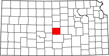
 Location within Rice County (left) and Kansas (right) | |
| Coordinates: 38°30′47″N 98°16′4″W / 38.51306°N 98.26778°WCoordinates: 38°30′47″N 98°16′4″W / 38.51306°N 98.26778°W | |
| Country | United States |
| State | Kansas |
| County | Rice |
| Area[1] | |
| • Total | 0.19 sq mi (0.49 km2) |
| • Land | 0.19 sq mi (0.49 km2) |
| • Water | 0 sq mi (0 km2) |
| Elevation | 1,759 ft (536 m) |
| Population (2010)[2] | |
| • Total | 18 |
| • Estimate (2012[3]) | 18 |
| • Density | 95/sq mi (37/km2) |
| Time zone | Central (CST) (UTC-6) |
| • Summer (DST) | CDT (UTC-5) |
| FIPS code | 20-24550 [4] |
| GNIS feature ID | 0475554 [5] |
Frederick is a city in Rice County, Kansas, United States. As of the 2010 census, the city population was 18.[6]
History
For millennia, the land now known as Kansas was inhabited by Native Americans. In 1803, most of modern Kansas was secured by the United States as part of the Louisiana Purchase. In 1854, the Kansas Territory was organized, then in 1861 Kansas became the 34th U.S. state. In 1867, Rice County was founded.
Frederick was a shipping point at the junction of the Missouri Pacific and the St. Louis & San Francisco railroads.[7]
A post office was opened in Frederick (also spelled historically Frederic) in 1887, and remained in operation until it was discontinued in 1954.[8]
Geography
Frederick is located at 38°30′47″N 98°16′4″W / 38.51306°N 98.26778°W (38.513108, -98.267756).[9] According to the United States Census Bureau, the city has a total area of 0.19 square miles (0.49 km2), all of it land.[1]
Demographics
| Historical population | |||
|---|---|---|---|
| Census | Pop. | %± | |
| 1990 | 18 | — | |
| 2000 | 11 | −38.9% | |
| 2010 | 18 | 63.6% | |
| U.S. Decennial Census | |||
2010 census
As of the census[2] of 2010, there were 18 people, 8 households, and 6 families residing in the city. The population density was 94.7 inhabitants per square mile (36.6/km2). There were 10 housing units at an average density of 52.6 per square mile (20.3/km2). The racial makeup of the city was 100.0% White.
There were 8 households of which 25.0% had children under the age of 18 living with them, 75.0% were married couples living together, and 25.0% were non-families. 25.0% of all households were made up of individuals and 12.5% had someone living alone who was 65 years of age or older. The average household size was 2.25 and the average family size was 2.67.
The median age in the city was 48.5 years. 22.2% of residents were under the age of 18; 0.0% were between the ages of 18 and 24; 22.2% were from 25 to 44; 50.1% were from 45 to 64; and 5.6% were 65 years of age or older. The gender makeup of the city was 50.0% male and 50.0% female.
2000 census
As of the census[4] of 2000, there were 11 people, 7 households, and 3 families residing in the city. The population density was 57.1 people per square mile (22.4/km²). There were 7 housing units at an average density of 36.3 per square mile (14.2/km²). The racial makeup of the city was 100.00% White.
There were 7 households out of which none had children under the age of 18 living with them, 57.1% were married couples living together, and 42.9% were non-families. 42.9% of all households were made up of individuals and 14.3% had someone living alone who was 65 years of age or older. The average household size was 1.57 and the average family size was 2.00.
In the city the population was spread out with 54.5% from 45 to 64, and 45.5% who were 65 years of age or older. The median age was 54 years. For every 100 females there were 120.0 males. For every 100 females age 18 and over, there were 120.0 males.
The median income for a household in the city was $46,250, and the median income for a family was $46,250. Males had a median income of $19,375 versus $26,250 for females. The per capita income for the city was $20,845. None of the population and none of the families were below the poverty line.
References
- ↑ 1.0 1.1 "US Gazetteer files 2010". United States Census Bureau. Retrieved 2012-07-06.
- ↑ 2.0 2.1 "American FactFinder". United States Census Bureau. Retrieved 2012-07-06.
- ↑ "Population Estimates". United States Census Bureau. Retrieved 2013-05-29.
- ↑ 4.0 4.1 "American FactFinder". United States Census Bureau. Retrieved 2008-01-31.
- ↑ "US Board on Geographic Names". United States Geological Survey. 2007-10-25. Retrieved 2008-01-31.
- ↑ "2010 City Population and Housing Occupancy Status". U.S. Census Bureau. Retrieved September 26, 2011.
- ↑ Blackmar, Frank Wilson (1912). Kansas: A Cyclopedia of State History, Embracing Events, Institutions, Industries, Counties, Cities, Towns, Prominent Persons, Etc. Standard Publishing Company. p. 684.
- ↑ "Kansas Post Offices, 1828-1961". Kansas Historical Society. Retrieved 22 June 2014.
- ↑ "US Gazetteer files: 2010, 2000, and 1990". United States Census Bureau. 2011-02-12. Retrieved 2011-04-23.
External links
- City
| Wikimedia Commons has media related to Frederick, Kansas. |
- Schools
- USD 444, local school district
- Maps
- Frederick City Map, KDOT
| |||||||||||||||||||||