Frankston South, Victoria
| Frankston South Melbourne, Victoria | |||||||||||||
|---|---|---|---|---|---|---|---|---|---|---|---|---|---|
|
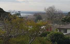
Rooftops of Frankston South, with glimpses of Port Phillip and Seaford Pier | |||||||||||||
 Frankston South | |||||||||||||
| Coordinates | 38°11′17″S 145°09′11″E / 38.188°S 145.153°ECoordinates: 38°11′17″S 145°09′11″E / 38.188°S 145.153°E | ||||||||||||
| Population | 17,360 (2006)[1] | ||||||||||||
| • Density | 1,173/km2 (3,038/sq mi) | ||||||||||||
| Established | 1846 (land sales: 1854) | ||||||||||||
| Postcode(s) | 3199 | ||||||||||||
| Area | 14.8 km2 (5.7 sq mi) | ||||||||||||
| Location | |||||||||||||
| LGA(s) | City of Frankston | ||||||||||||
| State electorate(s) | Frankston | ||||||||||||
| Federal Division(s) | Dunkley | ||||||||||||
| |||||||||||||
Frankston South is a suburb in Melbourne, Victoria, Australia, 43 km south-east of Melbourne's central business district. Its local government area is the City of Frankston. At the 2006 Census, Frankston South had a population of 17,360.
Sharing the same postcode as Frankston (3199), it is a separate suburb.[1]
History
After the settlement of Melbourne in 1835, James Davey took up a large land holding in 1846, which extended from Olivers Hill (in the beginnings of what is now Frankston South) to Daveys Bay (in what is now the neighbouring suburb of Mount Eliza).[2] Thomas McComb, who arrived at Frankston in 1852, also purchased much land in what is now the Frankston CBD and its south-east, in 1854.[2] Davey's and McComb's land was subdivided and now forms much of the suburb of Frankston South.
The first temporary post office in Frankston South opened in 1934 to service the first Australian Scout Jamboree.[3] The first permanent post office opened on 27 October 1958.[4] Since at least 1980, the PO is located in a small general store close to where the first Jamboree took place, on the intersection of Overport Road and Yuille Street, where in fact Overport Road begins at its northernmost point, and terminates as a T intersection at Humphries Road, some 4 km South.
After the arrival of the railway line in 1882, the Frankston area developed into a popular seaside resort and playground for Melbourne's affluent, with some developing large holiday properties in the area of Frankston South, many of which still stand today.[2]
1935 Scout Jamboree
Frankston South was the site of the first ever Australian Scout Jamboree, in 1935, which was attended by the founder of the Scouting movement, Sir Robert Baden-Powell.[2] The site was chosen for its proximity to the town of Frankston, distance from Melbourne and its relatively unspoilt natural areas as well as access to the beach.[5]
Several streets in Frankston South are named after the event (Baden Powell Drive being the most prominent), and the original grandstand used for the jamboree remained a historic landmark at Frankston Park for 72 years, until it was destroyed by fire on 12 February 2008.[6]
Subdivisions
Frankston South is home to the most expensive residential real estate in the City of Frankston, mainly due to its hilly terrain which allows for views of Port Phillip Bay, tree-lined streets, properties built on the edge of Sweetwater Creek Nature Reserve (which is located in the centre of the locality), and large land sub-divisions in the locality's far south.
Olivers Hill, which straddles the suburbs of Frankston and Frankston South, boasts expansive views across Port Phillip Bay to the city of Melbourne and overlooks the Frankston Beach and the Frankston waterfront. Some properties on Olivers Hill have been sold for in excess of A$2 million, when the 2005 median price for a house in Frankston was only A$228,000 according to The Age newspaper.[7]
Schools
- Derinya Primary School
- Overport Primary School
- St. Augustine's Primary School (Catholic private)
- Woodleigh School, junior campus (independent private), note: the senior campus is in the neighbouring suburb of Baxter.
Frankston High School is considered one of the more highly regarded secondary schools in the Frankston area, with VCE results consistently at the state median level, placing the school well into the top 150 statewide.[8] Admittance to Frankston High School is based on residence in the designated "zone" of the school. Real estate agents often market properties in the area around Frankston South as in the "FHS Zone" to lure families wishing to send their children to the school.
Shopping
Frankston South has no major shopping areas, due to its proximity to the Frankston Central Business District. However, small neighbourhood shopping strips exist in Norman Avenue, Foote Street and on Overport Road. The far-south of the suburb is also served by the shopping village in neighbouring Mount Eliza.
Infrastructure
Health
Due to its proximity to the Frankston Central Business District there is no hospital in Frankston South, however, it is served by the relatively close Frankston Hospital and also the Frankston Private Hospital. The area does support a number of health clinics and small specialist health surgeries.
Transport
Frankston South is located close to the Frankston Central Business District, and much of the suburb is accessible via the small arterials: Kars Street, Baden Powell Drive and Overport Road. It is also straddled by the Nepean Highway to the west and the Moorooduc Highway to the east. Bus services run throughout the locality, and connect it to the Frankston CBD as well as a number of neighbouring localities and suburbs. It also has many trains running through it.
Gallery
-
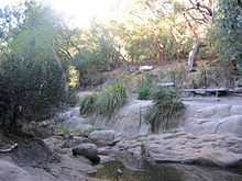
Granite rock formation in Sweetwater Creek Nature Reserve.
-
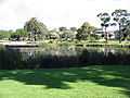
Beauty Park was converted from a swamp in the early 20th Century.
-
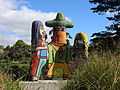
The mosaic sculpture "Power of Community" by Deborah Halpern in Beauty Park.
-
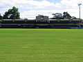
The former historical jamboree grandstand at Frankston Park football oval.
-

Frankston Beach.
-
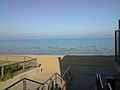
Frankston South outlook onto the beach.
References
- ↑ 1.0 1.1 Australian Bureau of Statistics (25 October 2007). "Frankston South (State Suburb)". 2006 Census QuickStats. Retrieved 26 September 2007.
- ↑ 2.0 2.1 2.2 2.3 Jones, Michael. Frankston: Resort to City. Allen & Unwin: Sydney. 1989. ISBN 0-04-442114-1
- ↑ Premier Postal History, Post Office List, retrieved 23 September 2008
- ↑ Premier Postal History, Post Office List: Australian Jamboree, Frankston, retrieved 11 April 2008
- ↑ 1935 Australian Jamboree, Frankston, Victoria
- ↑ ABC News - Fire destroys historic Frankston grandstand, 13 February 2008
- ↑ The Age - Surprise jump in home prices, 29 January 2005
- ↑ http://bettereducation.com.au/Results/vce.aspx