Frankenthal, Saxony
For other uses, see Frankenthal (disambiguation).
| Frankenthal | |
|---|---|
 Frankenthal | |
Location of Frankenthal within Bautzen district 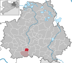
 | |
| Coordinates: 51°8′N 14°7′E / 51.133°N 14.117°ECoordinates: 51°8′N 14°7′E / 51.133°N 14.117°E | |
| Country | Germany |
| State | Saxony |
| District | Bautzen |
| Municipal assoc. | Großharthau |
| Government | |
| • Mayor | Kerstin Otto (CDU) |
| Area | |
| • Total | 9.43 km2 (3.64 sq mi) |
| Population (2013-12-31)[1] | |
| • Total | 957 |
| • Density | 100/km2 (260/sq mi) |
| Time zone | CET/CEST (UTC+1/+2) |
| Postal codes | 01909 |
| Dialling codes | 035954 |
| Vehicle registration | BZ |
| Website | www.gemeinde-frankenthal.de |
Frankenthal is a municipality in eastern Saxony, Germany. It belongs to the district of Bautzen and lies west of the eponymous city. It is named after Frankish colonists who settled in Lusatia ca. 1200.
Frankenthal is situated at the northern edge of the Lausitzer Bergland (Lusatian Hills), near the city of Bischofswerda.
References
- ↑ "Statistisches Landesamt des Freistaates Sachsen – Bevölkerung des Freistaates Sachsen jeweils am Monatsende ausgewählter Berichtsmonate nach Gemeinden" (PDF). Statistisches Landesamt des Freistaates Sachsen (in German). 6 September 2014.
Sources
- Frankenthal. In: August Schumann: Vollständiges Staats-, Post- und Zeitungslexikon von Sachsen. Volume 2, Zwickau 1815, p. 692 f.
- Frankenthal. In: August Schumann: Vollständiges Staats-, Post- und Zeitungslexikon von Sachsen. Volume 15, Zwickau 1828, p. 824 f.
External links
| Wikimedia Commons has media related to Frankenthal (Sachsen). |