Fourteener

In mountaineering terminology in the United States, a fourteener is a mountain that meets or exceeds an elevation of 14,000 feet (4,270 m) above mean sea level. Colorado has the majority of fourteeners in the contiguous United States (53), followed by California, which has the second largest group of such peaks in the lower 48 states (12). Climbing all of Colorado's fourteeners is a popular pastime among peak baggers; another popular target is climbing all of the fourteeners in the contiguous United States. Various ski mountaineers have completed ski descents of all the Colorado fourteeners, and the first attempts are being made to complete ski descents of all U.S. fourteeners.
Topographic elevation is the vertical distance above the reference geoid, a precise mathematical model of the Earth's sea level as an equipotential gravitational surface. Topographic prominence is the elevation difference between the summit and the highest or key col to a higher summit. Topographic isolation is the minimum great circle distance to a point of higher elevation.
All elevations in the 48 states of the contiguous United States include an elevation adjustment from the National Geodetic Vertical Datum of 1929 (NGVD 29) to the North American Vertical Datum of 1988 (NAVD 88).[1] If a summit elevation or prominence has a range of values, the arithmetic mean is cited.
Qualification criteria
Not all summits over 14,000 feet qualify as fourteeners.[2] Summits which qualify are those considered by mountaineers to be independent. Objective standards for independence include topographic prominence and isolation (distance from a higher summit), or a combination of the two. However, fourteener lists do not always consistently use such objective rules.
A rule commonly used by mountaineers in the contiguous United States is that a peak must have at least 300 feet (91 m) of prominence to qualify. By this rule, Colorado has 53 fourteeners, California has 12, and Washington has two.
According to the Mountaineering Club of Alaska, it is standard in Alaska to use a 500-foot (150 m) prominence rule rather than a 300-foot (91 m) rule. By this rule, Alaska has at least 21 peaks over 14,000 feet (4,267 m) and its 12 highest peaks exceed 15,000 feet (4,572 m).
For comparison, Canada has 15 fourteeners, and Mexico has 8; however, the importance of the 14,000-foot mark is minimal outside of the U.S. (due in large part to the otherwise universal usage of the metric system). In Europe, a peak 2,500-metre (8,202 ft) would be considered high (similar to the 10,000 feet mark in the U.S.), and it is very common to attempt to climb all of the independent 4,000-metre (13,123 ft) peaks in the Alps; that pastime roughly corresponds to fourteener-bagging in the U.S.
14ers.com is a free website created to document information on 14ers, as well as inform climbers of current conditions on these mountains.[3] The site has numerous current photos of mountains as well as an extremely active community on its forums.
Table
Topographic prominence
The table above uses a topographic prominence criterion of 300 feet. If a criterion of 100 meters of prominence is used instead, the table above shrinks to 85 summits. If a criterion of either 150 meters or 500 feet of prominence is used, the table above shrinks to 76 summits.
The following U.S. summits have 14,000 feet of elevation, but have less than 300 feet of topographic prominence:
- Mount McKinley, Browne Tower, 14,530, Alaska. Prominence = 25–125 feet (7.6–38.1 m). It is unclear why this became included on some fourteener lists.
- Mount Cameron, 14,238, Colorado. Prominence = 118 feet.
- El Diente Peak, 14,159, Colorado. Prominence = 239 feet. On many fourteener lists.
- Point Success, 14,158, Washington. Prominence = 118 feet.
- Polemonium Peak, 14,080+, California. Prominence = 160–240 feet.
- Starlight Peak, 14,080, California. Prominence = 80–160 feet.
- North Conundrum Peak, 14,040+, Colorado. Prominence = 200–280 feet.
- North Eolus, 14,039, Colorado. Prominence = 159–199 feet.
- North Maroon Peak, 14,014, Colorado. Prominence = 234 feet. On many fourteener lists.
- Thunderbolt Peak, 14,003, California. Prominence = 223 feet.
Gallery
-
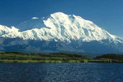
Mount McKinley (North Peak), Alaska
-
Maroon Bells (Maroon Peak and North Maroon Peak), Colorado


See also
- Outline of the United States
- Index of United States-related articles
- 4000 meter peaks of Alaska
- 4000 meter peaks of California
- 4000 meter peaks of Colorado
- 4000 meter peaks of North America
- 4000 meter peaks of the United States
- List of California fourteeners
- List of Colorado fourteeners
- Table of the highest major summits of the United States (uses 500 meter prominence criteria)
- Thirteener
References
- ↑ "What are NGVD 29 and NAVD 88?". National Geodetic Survey. 20 September 2010. Retrieved 6 October 2010.
- ↑ Blake, Kevin S. 2002. Colorado Fourteeners and the Nature of Place Identity. Geographical Review 92(2): 155-179.
- ↑ 14ers.com http://www.14ers.com/. Missing or empty
|title=(help) - ↑ Mount McKinley is the highest point of the Alaska Range, the State of Alaska, the United States of America, and all of North America
- ↑ "Mount McKinley". Summits of the World. peakbagger.com. Retrieved February 27, 2010.
- ↑ "Mount McKinley North Peak". NGS Station Datasheet. United States National Geodetic Survey. Retrieved March 13, 2010.
- ↑ "Mount McKinley North Peak". Summits of the World. peakbagger.com. Retrieved March 13, 2010.
- ↑ Mount Saint Elias on the international border between Alaska and the Yukon is the second highest mountain peak of both Canada and the United States
- ↑ "Mount Saint Elias". Summits of the World. peakbagger.com. Retrieved February 11, 2010.
- ↑ Mount Foraker is the westernmost 5000 m (16,404-foot) summit of North America
- ↑ "Mount Foraker". NGS Station Datasheet. United States National Geodetic Survey. Retrieved February 27, 2010.
- ↑ "Mount Foraker". Summits of the World. peakbagger.com. Retrieved February 27, 2010.
- ↑ "Mount Bona". NGS Station Datasheet. United States National Geodetic Survey. Retrieved February 27, 2010.
- ↑ "Mount Bona". Summits of the World. peakbagger.com. Retrieved February 27, 2010.
- ↑ "Mount Blackburn". NGS Station Datasheet. United States National Geodetic Survey. Retrieved February 11, 2010.
- ↑ "Mount Blackburn". Summits of the World. peakbagger.com. Retrieved February 11, 2010.
- ↑ "Mount Blackburn Southeast Peak". Summits of the World. peakbagger.com. Retrieved March 13, 2010.
- ↑ "Mount Sanford". Summits of the World. peakbagger.com. Retrieved February 27, 2010.
- ↑ "Mount McKinley South Buttress". Summits of the World. peakbagger.com. Retrieved March 13, 2010.
- ↑ "Mount Vancouver South Peak". NGS Station Datasheet. United States National Geodetic Survey. Retrieved March 13, 2010.
- ↑ "Mount Vancouver South Peak". Summits of the World. peakbagger.com. Retrieved March 13, 2010.
- ↑ "Mount Churchill". Summits of the World. peakbagger.com. Retrieved March 13, 2010.
- ↑ Mount Fairweather on the border of Alaska is the highest point of the Province of British Columbia
- ↑ "Mount Fairweather". Summits of the World. peakbagger.com. Retrieved February 11, 2010.
- ↑ "Mount Hubbard". Summits of the World. peakbagger.com. Retrieved January 25, 2010.
- ↑ "Mount Bear". Summits of the World. peakbagger.com. Retrieved February 27, 2010.
- ↑ "Mount McKinley East Buttress". Summits of the World. peakbagger.com. Retrieved March 13, 2010.
- ↑ "Mount Hunter". NGS Station Datasheet. United States National Geodetic Survey. Retrieved February 27, 2010.
- ↑ "Mount Hunter". Summits of the World. peakbagger.com. Retrieved February 27, 2010.
- ↑ Mount Whitney is the highest point of the Sierra Nevada, the State of California, and the contiguous United States
- ↑ "Mount Whitney". NGS Station Datasheet. United States National Geodetic Survey. Retrieved February 17, 2010.
- ↑ "Mount Whitney". Summits of the World. peakbagger.com. Retrieved February 17, 2010.
- ↑ The elevation of Mount Whitney includes an adjustment of +1.869 m (+6.13 ft) from NGVD 29 to NAVD 88.
- ↑ "Mount Alverstone". Summits of the World. peakbagger.com. Retrieved January 25, 2010.
- ↑ "University Peak". Summits of the World. peakbagger.com. Retrieved February 27, 2010.
- ↑ "Aello Peak". Summits of the World. peakbagger.com. Retrieved March 13, 2010.
- ↑ Mount Elbert is the highest point of the Rocky Mountains and the State of Colorado
- ↑ "Mount Elbert". NGS Station Datasheet. United States National Geodetic Survey. Retrieved February 17, 2010.
- ↑ "Mount Elbert". Summits of the World. peakbagger.com. Retrieved February 17, 2010.
- ↑ The elevation of Mount Elbert includes an adjustment of +1.995 m (+6.55 ft) from NGVD 29 to NAVD 88.
- ↑ "Mount Massive". NGS Station Datasheet. United States National Geodetic Survey. Retrieved February 17, 2010.
- ↑ "Mount Massive". Summits of the World. peakbagger.com. Retrieved February 17, 2010.
- ↑ The elevation of Mount Massive includes an adjustment of +2.087 m (+6.85 ft) from NGVD 29 to NAVD 88.
- ↑ "Mount Harvard". NGS Station Datasheet. United States National Geodetic Survey. Retrieved February 17, 2010.
- ↑ "Mount Harvard". Summits of the World. peakbagger.com. Retrieved February 17, 2010.
- ↑ The elevation of Mount Harvard includes an adjustment of +2.084 m (+6.84 ft) from NGVD 29 to NAVD 88.
- ↑ The summit elevation of Mount Harvard includes a vertical offset of +1.8 m (+5.9 ft) from the benchmark.
- ↑ Mount Rainier is the highest point of the Cascade Range and the State of Washington
- ↑ "Mount Rainier". NGS Station Datasheet. United States National Geodetic Survey. Retrieved February 27, 2010.
- ↑ "Mount Rainier". Summits of the World. peakbagger.com. Retrieved February 27, 2010.
- ↑ The elevation of Mount Rainier includes an adjustment of +1.935 m (+6.35 ft) from NGVD 29 to NAVD 88.
- ↑ "Mount Williamson". Summits of the World. peakbagger.com. Retrieved February 28, 2010.
- ↑ The elevation of Mount Williamson includes an adjustment of +1.807 m (+5.93 ft) from NGVD 29 to NAVD 88.
- ↑ "La Plata Peak". Summits of the World. peakbagger.com. Retrieved February 28, 2010.
- ↑ The elevation of La Plata Peak includes an adjustment of +1.983 m (+6.51 ft) from NGVD 29 to NAVD 88.
- ↑ "Blanca Peak". NGS Station Datasheet. United States National Geodetic Survey. Retrieved March 2, 2010.
- ↑ "Blanca Peak". Summits of the World. peakbagger.com. Retrieved March 2, 2010.
- ↑ The elevation of Blanca Peak includes an adjustment of +1.755 m (+5.76 ft) from NGVD 29 to NAVD 88.
- ↑ "Uncompahgre Peak". NGS Station Datasheet. United States National Geodetic Survey. Retrieved February 17, 2010.
- ↑ "Uncompahgre Peak". Summits of the World. peakbagger.com. Retrieved February 17, 2010.
- ↑ The elevation of Uncompahgre Peak includes an adjustment of +1.967 m (+6.45 ft) from NGVD 29 to NAVD 88.
- ↑ "Crestone Peak". Summits of the World. peakbagger.com. Retrieved March 2, 2010.
- ↑ The elevation of Crestone Peak includes an adjustment of +1.76 m (+5.77 ft) from NGVD 29 to NAVD 88.
- ↑ "Mount Lincoln". NGS Station Datasheet. United States National Geodetic Survey. Retrieved February 17, 2010.
- ↑ "Mount Lincoln". Summits of the World. peakbagger.com. Retrieved February 17, 2010.
- ↑ The elevation of Mount Lincoln includes an adjustment of +2.098 m (+6.88 ft) from NGVD 29 to NAVD 88.
- ↑ "Castle Peak". NGS Station Datasheet. United States National Geodetic Survey. Retrieved February 17, 2010.
- ↑ "Castle Peak". Summits of the World. peakbagger.com. Retrieved February 17, 2010.
- ↑ The elevation of Castle Peak includes an adjustment of +2.165 m (+7.10 ft) from NGVD 29 to NAVD 88.
- ↑ Grays Peak is the highest point on the Continental Divide of North America
- ↑ "Grays Peak". NGS Station Datasheet. United States National Geodetic Survey. Retrieved February 17, 2010.
- ↑ "Grays Peak". Summits of the World. peakbagger.com. Retrieved February 17, 2010.
- ↑ The elevation of Grays Peak includes an adjustment of +1.881 m (+6.17 ft) from NGVD 29 to NAVD 88.
- ↑ "Mount Antero". NGS Station Datasheet. United States National Geodetic Survey. Retrieved February 17, 2010.
- ↑ "Mount Antero". Summits of the World. peakbagger.com. Retrieved February 17, 2010.
- ↑ The elevation of Mount Antero includes an adjustment of +2.071 m (+6.79 ft) from NGVD 29 to NAVD 88.
- ↑ "Torreys Peak". NGS Station Datasheet. United States National Geodetic Survey. Retrieved March 13, 2010.
- ↑ "Torreys Peak". Summits of the World. peakbagger.com. Retrieved March 13, 2010.
- ↑ The elevation of Torreys Peak includes an adjustment of +1.897 m (+6.22 ft) from NGVD 29 to NAVD 88.
- ↑ "Quandary Peak". NGS Station Datasheet. United States National Geodetic Survey. Retrieved March 15, 2010.
- ↑ "Quandary Peak". Summits of the World. peakbagger.com. Retrieved March 15, 2010.
- ↑ The elevation of Quandary Peak includes an adjustment of +2.071 m (+6.79 ft) from NGVD 29 to NAVD 88.
- ↑ "Mount Evans". NGS Station Datasheet. United States National Geodetic Survey. Retrieved February 17, 2010.
- ↑ "Mount Evans". Summits of the World. peakbagger.com. Retrieved February 17, 2010.
- ↑ The elevation of Mount Evans includes an adjustment of +1.827 m (+5.99 ft) from NGVD 29 to NAVD 88.
- ↑ "Longs Peak". NGS Station Datasheet. United States National Geodetic Survey. Retrieved February 17, 2010.
- ↑ "Longs Peak". Summits of the World. peakbagger.com. Retrieved February 17, 2010.
- ↑ The elevation of Longs Peak includes an adjustment of +1.652 m (+5.42 ft) from NGVD 29 to NAVD 88.
- ↑ "Mount Wilson". Summits of the World. peakbagger.com. Retrieved March 2, 2010.
- ↑ The elevation of Mount Wilson includes an adjustment of +1.899 m (+6.23 ft) from NGVD 29 to NAVD 88.
- ↑ "White Mountain Peak". NGS Station Datasheet. United States National Geodetic Survey. Retrieved February 17, 2010.
- ↑ "White Mountain Peak". Summits of the World. peakbagger.com. Retrieved February 17, 2010.
- ↑ The elevation of White Mountain Peak includes an adjustment of +1.91 m (+6.27 ft) from NGVD 29 to NAVD 88.
- ↑ "North Palisade". NGS Station Datasheet. United States National Geodetic Survey. Retrieved February 17, 2010.
- ↑ "North Palisade". Summits of the World. peakbagger.com. Retrieved February 17, 2010.
- ↑ The elevation of North Palisade includes an adjustment of +1.867 m (+6.13 ft) from NGVD 29 to NAVD 88.
- ↑ "Mount Shavano". NGS Station Datasheet. United States National Geodetic Survey. Retrieved March 13, 2010.
- ↑ "Mount Shavano". Summits of the World. peakbagger.com. Retrieved March 13, 2010.
- ↑ The elevation of Mount Shavano includes an adjustment of +2.031 m (+6.66 ft) from NGVD 29 to NAVD 88.
- ↑ "Mount Princeton". NGS Station Datasheet. United States National Geodetic Survey. Retrieved February 17, 2010.
- ↑ "Mount Princeton". Summits of the World. peakbagger.com. Retrieved February 17, 2010.
- ↑ The elevation of Mount Princeton includes an adjustment of +2.075 m (+6.81 ft) from NGVD 29 to NAVD 88.
- ↑ "Mount Belford". NGS Station Datasheet. United States National Geodetic Survey. Retrieved March 13, 2010.
- ↑ "Mount Belford". Summits of the World. peakbagger.com. Retrieved March 13, 2010.
- ↑ The elevation of Mount Belford includes an adjustment of +2.081 m (+6.83 ft) from NGVD 29 to NAVD 88.
- ↑ "Crestone Needle". Summits of the World. peakbagger.com. Retrieved March 13, 2010.
- ↑ The elevation of Crestone Needle includes an adjustment of +1.763 m (+5.78 ft) from NGVD 29 to NAVD 88.
- ↑ "Mount Yale". NGS Station Datasheet. United States National Geodetic Survey. Retrieved February 17, 2010.
- ↑ "Mount Yale". Summits of the World. peakbagger.com. Retrieved February 17, 2010.
- ↑ The elevation of Mount Yale includes an adjustment of +2.036 m (+6.68 ft) from NGVD 29 to NAVD 88.
- ↑ The summit elevation of Mount Yale includes a vertical offset of +0.6 m (+2.0 ft) from the benchmark.
- ↑ "Mount Shasta". NGS Station Datasheet. United States National Geodetic Survey. Retrieved February 17, 2010.
- ↑ "Mount Shasta". Summits of the World. peakbagger.com. Retrieved February 17, 2010.
- ↑ The elevation of Mount Shasta includes an adjustment of +1.791 m (+5.88 ft) from NGVD 29 to NAVD 88.
- ↑ "Mount Bross". NGS Station Datasheet. United States National Geodetic Survey. Retrieved March 13, 2010.
- ↑ "Mount Bross". Summits of the World. peakbagger.com. Retrieved March 13, 2010.
- ↑ The elevation of Mount Bross includes an adjustment of +2.044 m (+6.71 ft) from NGVD 29 to NAVD 88.
- ↑ "Kit Carson Mountain". Summits of the World. peakbagger.com. Retrieved March 13, 2010.
- ↑ The elevation of Kit Carson Mountain includes an adjustment of +1.773 m (+5.82 ft) from NGVD 29 to NAVD 88.
- ↑ "Maroon Peak". NGS Station Datasheet. United States National Geodetic Survey. Retrieved February 17, 2010.
- ↑ "Maroon Peak". Summits of the World. peakbagger.com. Retrieved February 17, 2010.
- ↑ The elevation of Maroon Peak includes an adjustment of +2.048 m (+6.72 ft) from NGVD 29 to NAVD 88.
- ↑ "Mount Wrangell". Summits of the World. peakbagger.com. Retrieved February 27, 2010.
- ↑ "Tabeguache Peak". NGS Station Datasheet. United States National Geodetic Survey. Retrieved March 13, 2010.
- ↑ "Tabeguache Peak". Summits of the World. peakbagger.com. Retrieved March 13, 2010.
- ↑ The elevation of Tabeguache Peak includes an adjustment of +2.107 m (+6.91 ft) from NGVD 29 to NAVD 88.
- ↑ "Mount Oxford (Colorado)". NGS Station Datasheet. United States National Geodetic Survey. Retrieved March 13, 2010.
- ↑ "Mount Oxford (Colorado)". Summits of the World. peakbagger.com. Retrieved March 13, 2010.
- ↑ The elevation of Mount Oxford (Colorado) includes an adjustment of +2.042 m (+6.70 ft) from NGVD 29 to NAVD 88.
- ↑ "Mount Sill". Summits of the World. peakbagger.com. Retrieved March 15, 2010.
- ↑ The elevation of Mount Sill includes an adjustment of +1.888 m (+6.19 ft) from NGVD 29 to NAVD 88.
- ↑ "Mount Sneffels". NGS Station Datasheet. United States National Geodetic Survey. Retrieved February 17, 2010.
- ↑ "Mount Sneffels". Summits of the World. peakbagger.com. Retrieved February 17, 2010.
- ↑ The elevation of Mount Sneffels includes an adjustment of +1.879 m (+6.16 ft) from NGVD 29 to NAVD 88.
- ↑ "Mount Democrat". NGS Station Datasheet. United States National Geodetic Survey. Retrieved March 13, 2010.
- ↑ "Mount Democrat". Summits of the World. peakbagger.com. Retrieved March 13, 2010.
- ↑ The elevation of Mount Democrat includes an adjustment of +2.086 m (+6.84 ft) from NGVD 29 to NAVD 88.
- ↑ "Capitol Peak". NGS Station Datasheet. United States National Geodetic Survey. Retrieved February 17, 2010.
- ↑ "Capitol Peak". Summits of the World. peakbagger.com. Retrieved February 17, 2010.
- ↑ The elevation of Capitol Peak includes an adjustment of +1.991 m (+6.53 ft) from NGVD 29 to NAVD 88.
- ↑ "Liberty Cap". NGS Station Datasheet. United States National Geodetic Survey. Retrieved February 17, 2010.
- ↑ "Liberty Cap". Summits of the World. peakbagger.com. Retrieved February 17, 2010.
- ↑ The elevation of Liberty Cap includes an adjustment of +1.991 m (+6.53 ft) from NGVD 29 to NAVD 88.
- ↑ "Pikes Peak". NGS Station Datasheet. United States National Geodetic Survey. Retrieved February 17, 2010.
- ↑ "Pikes Peak". Summits of the World. peakbagger.com. Retrieved February 17, 2010.
- ↑ The elevation of Pikes Peak includes an adjustment of +1.678 m (+5.51 ft) from NGVD 29 to NAVD 88.
- ↑ "Snowmass Mountain". NGS Station Datasheet. United States National Geodetic Survey. Retrieved March 13, 2010.
- ↑ "Snowmass Mountain". Summits of the World. peakbagger.com. Retrieved March 13, 2010.
- ↑ The elevation of Snowmass Mountain includes an adjustment of +1.98 m (+6.50 ft) from NGVD 29 to NAVD 88.
- ↑ "Mount Russell". Summits of the World. peakbagger.com. Retrieved March 15, 2010.
- ↑ The elevation of Mount Russell includes an adjustment of +1.869 m (+6.13 ft) from NGVD 29 to NAVD 88.
- ↑ "Windom Peak". Summits of the World. peakbagger.com. Retrieved March 13, 2010.
- ↑ The elevation of Windom Peak includes an adjustment of +1.785 m (+5.86 ft) from NGVD 29 to NAVD 88.
- ↑ "Mount Eolus". Summits of the World. peakbagger.com. Retrieved February 28, 2010.
- ↑ The elevation of Mount Eolus includes an adjustment of +1.756 m (+5.76 ft) from NGVD 29 to NAVD 88.
- ↑ "Challenger Peak". Summits of the World. peakbagger.com. Retrieved March 13, 2010.
- ↑ The elevation of Challenger Peak includes an adjustment of +1.752 m (+5.75 ft) from NGVD 29 to NAVD 88.
- ↑ "Mount Columbia". NGS Station Datasheet. United States National Geodetic Survey. Retrieved March 13, 2010.
- ↑ "Mount Columbia". Summits of the World. peakbagger.com. Retrieved March 13, 2010.
- ↑ The elevation of Mount Columbia includes an adjustment of +2.081 m (+6.83 ft) from NGVD 29 to NAVD 88.
- ↑ "Missouri Mountain". NGS Station Datasheet. United States National Geodetic Survey. Retrieved March 13, 2010.
- ↑ "Missouri Mountain". Summits of the World. peakbagger.com. Retrieved March 13, 2010.
- ↑ The elevation of Missouri Mountain includes an adjustment of +2.113 m (+6.93 ft) from NGVD 29 to NAVD 88.
- ↑ "Mount Augusta". Summits of the World. peakbagger.com. Retrieved January 26, 2010.
- ↑ "Humboldt Peak". Summits of the World. peakbagger.com. Retrieved March 13, 2010.
- ↑ The elevation of Humboldt Peak includes an adjustment of +1.79 m (+5.87 ft) from NGVD 29 to NAVD 88.
- ↑ "Mount Bierstadt". NGS Station Datasheet. United States National Geodetic Survey. Retrieved March 13, 2010.
- ↑ "Mount Bierstadt". Summits of the World. peakbagger.com. Retrieved March 13, 2010.
- ↑ The elevation of Mount Bierstadt includes an adjustment of +1.797 m (+5.90 ft) from NGVD 29 to NAVD 88.
- ↑ "Sunlight Peak". Summits of the World. peakbagger.com. Retrieved March 13, 2010.
- ↑ The elevation of Sunlight Peak includes an adjustment of +1.804 m (+5.92 ft) from NGVD 29 to NAVD 88.
- ↑ "Split Mountain (California)". NGS Station Datasheet. United States National Geodetic Survey. Retrieved March 15, 2010.
- ↑ "Split Mountain (California)". Summits of the World. peakbagger.com. Retrieved March 15, 2010.
- ↑ The elevation of Split Mountain (California) includes an adjustment of +1.771 m (+5.81 ft) from NGVD 29 to NAVD 88.
- ↑ "Handies Peak". NGS Station Datasheet. United States National Geodetic Survey. Retrieved February 17, 2010.
- ↑ "Handies Peak". Summits of the World. peakbagger.com. Retrieved February 17, 2010.
- ↑ The elevation of Handies Peak includes an adjustment of +1.994 m (+6.54 ft) from NGVD 29 to NAVD 88.
- ↑ "Culebra Peak". Summits of the World. peakbagger.com. Retrieved March 2, 2010.
- ↑ The elevation of Culebra Peak includes an adjustment of +1.74 m (+5.71 ft) from NGVD 29 to NAVD 88.
- ↑ "Ellingwood Point". Summits of the World. peakbagger.com. Retrieved March 13, 2010.
- ↑ The elevation of Ellingwood Point includes an adjustment of +1.789 m (+5.87 ft) from NGVD 29 to NAVD 88.
- ↑ "Mount Lindsey". Summits of the World. peakbagger.com. Retrieved March 13, 2010.
- ↑ The elevation of Mount Lindsey includes an adjustment of +1.691 m (+5.55 ft) from NGVD 29 to NAVD 88.
- ↑ "Little Bear Peak". Summits of the World. peakbagger.com. Retrieved March 13, 2010.
- ↑ The elevation of Little Bear Peak includes an adjustment of +1.733 m (+5.69 ft) from NGVD 29 to NAVD 88.
- ↑ "Mount Sherman". Summits of the World. peakbagger.com. Retrieved March 13, 2010.
- ↑ The elevation of Mount Sherman includes an adjustment of +2.029 m (+6.66 ft) from NGVD 29 to NAVD 88.
- ↑ "Redcloud Peak". Summits of the World. peakbagger.com. Retrieved March 13, 2010.
- ↑ The elevation of Redcloud Peak includes an adjustment of +2.015 m (+6.61 ft) from NGVD 29 to NAVD 88.
- ↑ "Mount Langley". NGS Station Datasheet. United States National Geodetic Survey. Retrieved March 15, 2010.
- ↑ "Mount Langley". Summits of the World. peakbagger.com. Retrieved March 15, 2010.
- ↑ The elevation of Mount Langley includes an adjustment of +1.76 m (+5.77 ft) from NGVD 29 to NAVD 88.
- ↑ "Mount Tyndall". Summits of the World. peakbagger.com. Retrieved March 15, 2010.
- ↑ The elevation of Mount Tyndall includes an adjustment of +1.835 m (+6.02 ft) from NGVD 29 to NAVD 88.
- ↑ "Pyramid Peak (Colorado)". NGS Station Datasheet. United States National Geodetic Survey. Retrieved March 13, 2010.
- ↑ "Pyramid Peak (Colorado)". Summits of the World. peakbagger.com. Retrieved March 13, 2010.
- ↑ The elevation of Pyramid Peak (Colorado) includes an adjustment of +2.009 m (+6.59 ft) from NGVD 29 to NAVD 88.
- ↑ "Wilson Peak". Summits of the World. peakbagger.com. Retrieved March 13, 2010.
- ↑ The elevation of Wilson Peak includes an adjustment of +1.877 m (+6.16 ft) from NGVD 29 to NAVD 88.
- ↑ "San Luis Peak". NGS Station Datasheet. United States National Geodetic Survey. Retrieved February 17, 2010.
- ↑ "San Luis Peak". Summits of the World. peakbagger.com. Retrieved February 17, 2010.
- ↑ The elevation of San Luis Peak includes an adjustment of +2.098 m (+6.88 ft) from NGVD 29 to NAVD 88.
- ↑ "Wetterhorn Peak". Summits of the World. peakbagger.com. Retrieved March 13, 2010.
- ↑ The elevation of Wetterhorn Peak includes an adjustment of +1.903 m (+6.24 ft) from NGVD 29 to NAVD 88.
- ↑ Mount Muir is unlikely to have 300 feet of prominence, though the mean prominence (using interpolation between contours) of Mount Muir is indeed 101 m (331 ft).
- ↑ "Mount Muir". Summits of the World. peakbagger.com. Retrieved March 15, 2010.
- ↑ The elevation of Mount Muir includes an adjustment of +1.857 m (+6.09 ft) from NGVD 29 to NAVD 88.
- ↑ "Middle Palisade". Summits of the World. peakbagger.com. Retrieved March 15, 2010.
- ↑ The elevation of Middle Palisade includes an adjustment of +1.835 m (+6.02 ft) from NGVD 29 to NAVD 88.
- ↑ "Mount Wrangell West Peak". Summits of the World. peakbagger.com. Retrieved March 15, 2010.
- ↑ "Huron Peak". NGS Station Datasheet. United States National Geodetic Survey. Retrieved March 13, 2010.
- ↑ "Huron Peak". Summits of the World. peakbagger.com. Retrieved March 13, 2010.
- ↑ The elevation of Huron Peak includes an adjustment of +2.08 m (+6.82 ft) from NGVD 29 to NAVD 88.
- ↑ The summit elevation of Huron Peak includes a vertical offset of +0.6 m (+2.0 ft) from the benchmark.
- ↑ "Mount of the Holy Cross". NGS Station Datasheet. United States National Geodetic Survey. Retrieved February 17, 2010.
- ↑ "Mount of the Holy Cross". Summits of the World. peakbagger.com. Retrieved February 17, 2010.
- ↑ The elevation of Mount of the Holy Cross includes an adjustment of +1.926 m (+6.32 ft) from NGVD 29 to NAVD 88.
- ↑ "Sunshine Peak". Summits of the World. peakbagger.com. Retrieved March 13, 2010.
- ↑ The elevation of Sunshine Peak includes an adjustment of +1.969 m (+6.46 ft) from NGVD 29 to NAVD 88.
External links
- Colorado 14ers, California 14ers, and the Alaska 14ers maps, photos, and summit history on peakery.com
- 14ers.com: Home of Colorado's Fourteeners
- Colorado 14er stickers
- "Fourteener list on peakbagger.com". Peakbagger.com. with prominence information
- peaklist.org (More prominence information for high-prominence peaks)
- Information on the fourteeners in Colorado
- Trip reports from Colorado Peaks
- California Thirteeners (VRMC) with interactive maps
- California Fourteeners (VRMC) with interactive maps