Fourilles
| Fourilles | ||
|---|---|---|
|
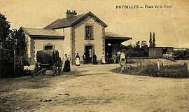
The railway station in Fourilles, in the early 20th century | ||
| ||
 Fourilles | ||
|
Location within Auvergne region  Fourilles | ||
| Coordinates: 46°14′33″N 3°11′45″E / 46.2425°N 3.1958°ECoordinates: 46°14′33″N 3°11′45″E / 46.2425°N 3.1958°E | ||
| Country | France | |
| Region | Auvergne | |
| Department | Allier | |
| Arrondissement | Moulins | |
| Canton | Chantelle | |
| Intercommunality | Pays Saint-Pourcinois | |
| Government | ||
| • Mayor (2008–2014) | Andrée Bucharles | |
| Area1 | 6.98 km2 (2.69 sq mi) | |
| Population (2008)2 | 207 | |
| • Density | 30/km2 (77/sq mi) | |
| INSEE/Postal code | 03116 / 03140 | |
| Elevation |
252–330 m (827–1,083 ft) (avg. 260 m or 850 ft) | |
|
1 French Land Register data, which excludes lakes, ponds, glaciers > 1 km² (0.386 sq mi or 247 acres) and river estuaries. 2 Population without double counting: residents of multiple communes (e.g., students and military personnel) only counted once. | ||
.svg.png)
Fourilles is a commune in the Allier department in central France.
Geography
The river Bouble flows northeast through the northern part of the commune.
Population
| Historical population | ||
|---|---|---|
| Year | Pop. | ±% |
| 1962 | 251 | — |
| 1968 | 264 | +5.2% |
| 1975 | 237 | −10.2% |
| 1982 | 198 | −16.5% |
| 1990 | 194 | −2.0% |
| 1999 | 188 | −3.1% |
| 2008 | 207 | +10.1% |
See also
References
| Wikimedia Commons has media related to Fourilles. |