Foum Zguid
| Foum Zguid | |
|---|---|
| Town | |
|
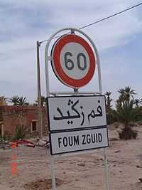
Entrance to Foum Zguid with sign in Roman and Arabic alphabets. | |
| Country |
|
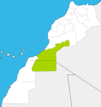
| Region | Guelmim-Es Semara |
| Province | Tata Province |
| Population (2004) | |
| • Total | 9,630 |
| Time zone | WET (UTC+0) |
| • Summer (DST) | WEST (UTC+1) |
Foum Zguid is a town in Tata Province, Guelmim-Es Semara, southeastern Morocco. According to the 2004 census it had a population of 9,630, the second-highest in the province after the capital Tata and seventh-highest in the region.[1]
Foum Zguid is on the N12 highway to the north of Tata and south of the border with the region of Souss-Massa-Drâa. The Irqui National Park is to the south of Foum Zguid, as is the border with Algeria, but no roads lead to either.
References
| |||||||||||||||||
Coordinates: 30°05′N 6°52′W / 30.083°N 6.867°W