Fossa Carolina
Coordinates: 48°59′02″N 10°55′18″E / 48.9840°N 10.9216°E
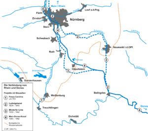
The Fossa Carolina (or Karlsgraben in German) was a navigable channel connecting the Swabian Rezat river to the Altmühl river (the Rhine basin to the Danube basin). It was created during the Middle Ages long before the Ludwig Canal and the Rhine-Main-Danube Canal. This channel was the first to link the Rhine basin to the Danube basin.
Overview
In 793 Charlemagne gave orders to dig a 3 kilometers long channel from Treuchtlingen to Weißenburg in Bayern. It seems that the goal of this work was to improve the transportation of goods between Rhineland and Bavaria. Another theory (less credible) tells that the main purpose was to bring back Charlemagne's war vessels from the Danube to the Rhine. According to some contemporary chroniclers, the channel was unfinished due to heavy rains and geological problems. But other sources let think that it was completed and fully operational. This channel worked with several ponds, dikes and dams.
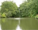
Today only a 500 meters long part of the Channel still exists.
References
External links
| Wikimedia Commons has media related to Fossa Carolina. |
- Fossa Carolina (English) at http://www.treuchtlingen.de
- The Fossa Carolina museum (German) at http://www.bayern.de/wwa-an which is the same page as http://www.wwa-an.bayern.de/. From this page the subsequent link to a page about "The Fossa Carolina museum" is not evident, for a non-German reader.
- Ingoldesstat und die Fossa Carolina Karls des Großen (German) at http://www.ingolstadt.de/stadtmuseum