Fortuneswell
| Fortuneswell | |
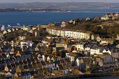 Fortuneswell from Priory Corner |
|
 Fortuneswell |
|
| OS grid reference | SY689732 |
|---|---|
| District | Weymouth and Portland |
| Shire county | Dorset |
| Region | South West |
| Country | England |
| Sovereign state | United Kingdom |
| Post town | PORTLAND |
| Postcode district | DT5 |
| Dialling code | 01305 |
| Police | Dorset |
| Fire | Dorset |
| Ambulance | South Western |
| EU Parliament | South West England |
Coordinates: 50°33′30″N 2°26′23″W / 50.55836°N 2.43968°W
Fortuneswell is a village in Underhill on the Isle of Portland, in Dorset, England. It lies on steeply sloping land on the northern edge of the island, known as Underhill, where Chesil Beach, the tombolo which connects the island to the mainland, joins the island.
Adjoining Fortuneswell and sharing the limited space on the northern slopes of the island are Chiswell to the west and Castletown to the north. Fortuneswell occupies the steepest land far above sea level, whereas Chiswell and Castletown occupy flat land close to sea level, next to Chesil Beach and Portland Harbour respectively.
As with the rest of Portland's settlements, Fortuneswell, including Maiden Well and Mallams, has been designated as a conservation area, to protect its special architectural and historic interest. Underhill, incorporating Chiswell, Maidenwell, Fortuneswell and Castletown, was designated in 1976, with boundary extensions in 1997 and 2000.[1][2]
Fortuneswell has a main shopping street with several shops, and along with Easton, is the main hub of the Isle of Portland's activities.
In Thomas Hardy's 1880 novel The Trumpet Major, he described the village as the "Street of Wells".[3]
History
In similarity with other settlements on Portland, Fortuneswell first flourished around a natural source of water. It remains most probable that the Romans first transformed many of Portland's springs into ponds and wells, while natural ponds would be enclosed and maintained from this period. Some residences had a personal cistern. In Fortuneswell's case, its name originated from the ancient well which was situated in the centre of the village. The well was fed by a spring which ran down from Verne Hill.[4] The name was first recorded as "Fortunes Well" in 1608, and certain evidence suggests the name has originated from the belief in the occult star-telling power of its water, where one's luck could be seen.[5] During the early 20th century, around the period of World War I, the village well was sealed and covered by the local council, though the spring continues to run underground through pipes.
The traditional industries for the residents of the village was either fishing or quarrying. By the 16th to 17th centuries the village was not as compact as seen today, but featured high-quality houses, with considerable land attached to, and between, each. These dwellings were largely built by stone merchants and sea captains. However the village was substantially changed in the late 19th century, when Portland saw a massive expansion within its population, directly due to the labour-demanding projects of building Portland's harbour breakwaters and the defensive Verne Citadel.[6] With the demand for new housing, local residents expressed their wishes for the new houses to keep with the tradition of the current residences, by being detached or semi-detached, and including individual gardens. However a large number of terraced houses were built across the village instead. As such the majority of housing in Fortuneswell was crammed into any available space, including farmland and gardens.[7]
One major benefit to Fortuneswell was the business opportunity the new population opened to the island, and as a result many successful businesses were established in the village. From this point the village, along with Easton, was one of Portland's main centres for business. The Victorian period saw the main street transformed with facades of stylish carved masonry and grand windows. A bank was opened in 1861, under the name Eliots Bank, and this building still survives today, though it is no longer occupied by any business. Further north along the street Captain Abraham Scriven had the Royal Hotel built for a cost of £3000. A large drapery emporium was built in the village in 1866 by Henry Russell.[7]
The local council had a gasworks constructed at the neighbouring Chiswell village, as well as various sewerage systems and reservoirs installed, as the island's current water supply via the natural springs was no longer able to cope with the increasing demand. However these measures proved to be insufficient, and by 1881 local residents of Fortuneswell would often have to wait for up to 20 minutes to gain access to the village well. The island's living conditions continued to deteriorate, and so disease, such as such as measles and typhoid, spread. Eventually a piped water supply was laid in the early 20th century. The local education system could no longer cope either, and any available schools had become overcrowded, particularly in Underhill. A local Miss Clara White decided to open a new private school at Manor Place as a direct result of this.[7]
From 1930 a demolition scheme by the local council threatened a considerable number of historical houses on the island. Despite strong local objection, much of the island's historic, Jacobean, Tudor and Georgian cottages would be demolished, rather than being restored. This included various dwellings at Fortuneswell. The compulsory night-time blackouts during the Second World War led to residents having accidents outdoors, and so specially marked hurricane lamps were hung around the village to avoid this. With the important naval base, Portland was a natural target for German aircraft during the war, and Fortuneswell had various cases of raids and bombings. This led to various houses and shop premises being destroyed, including the popular public house The Sun Inn, which eventually had to be demolished. On 15 September 1940, St John's School was destroyed when a bomb fell in its playground. However as the school was closed at the time no fatalities occurred.[8]
After the war a need for new housing returned, and as such many houses were constructed in Tophill, particularly Weston village. The biggest part Underhill played in this project was the expansive housing estate situated on the hillside of Verne Common. The initial suggestion was to build high-quality villas on the hillside, which was fitting with the site's panoramic view across to the mainland. It was believed this scheme would attract more professional people to live on the island, rather than choosing Weymouth instead. However in 1949 the council decided to grant permission for the construction of hundreds of permanent prefabricated low rent houses, which was a more time and utility-efficient option. These houses at Verne Common, including East Weare Road overlook Castletown, although are designated part of Fortuneswell. In 1963, the village's one way traffic system was introduced.[9] With the closure of the naval base in 1995, Fortuneswell has since seen an economic decline in business, though various independent stores continue to remain active, and serve the community, to date.
Commerce and amenities

Over the last few decades, many shops in Fortuneswell have changed hands frequently, while a few shops have lasted longer periods and became familiar businesses before eventually ceasing trading. One notable example is Way's Shop, which dated back from the 18th century, and continued trading until it closed in early 1973.[10] Fortuneswell was the main business centre on Portland until the 1970s, when many well-established businesses ceased trading. However in 1995 a refurbishment scheme over Underhill bought new life and confidence to the village. Current various shops and businesses include a tailor shop, a carpet and furniture stores, a café, a pharmacy, a fish & chip shop, a hardware store, an estate agent, a newsagent/post office, and a hairdresser. A small number of commercial property and shops in Fortuneswell have been victim to fires, which were suspected to be arson, including a takeaway shop, a greengrocers and a nightclub in the late 1980s and early 1990s.
The New Star Inn, Royal Portland Arms and the Britannia Inn are located in Fortunewell.[11] Close to the New Star Inn once stood the now gone Meissner's Knap – the Royal Hotel built by Captain Abraham Scriven in 1863, which hosted many important visitors to the breakwater works.[12] The British Legion Hall, in High Street, was erected in 1926 over the premises of what is now the British Legion Club. It was formerly known as the Yerburgh Hall. At East Street there remains a well-equipped Working Men's Club. It is known as the North Portland Working Men's Club, while the South Portland Working Men's Conservative Club is located within Easton Square, in the Jubilee Hall of 1888.[13]
The no longer remaining Regal Cinema was built in Fortuneswell during 1932 and blocked the view of St. John's Church. It was very popular until the advent of television, and in the 1960s it tried to boost patrons by specialising in 'X' Certificate films, particularly as entertainment for Royal Navy sailors. It then became a popular Bingo hall. In the 1990s the building had renewed interest when it became Rumours Nightclub, which featured a large model aircraft hung from the ceiling of the dance floor. A victim of suspected arson, the nightclub caught fire one evening in 1992 and the remaining shell was demolished soon after. The damage caused was valued at over £175,000. Easton also had a cinema; Easton Palace. Almost opposite the site of the Regal Cinema site is Portland's smallest thoroughfare - Manor Place which is less than thirty inches wide but serves several houses.[14] Within the area of the old site of the cinema stands the Royal Manor Theatre.
A reminder of industry in the back streets of Fortuneswell lies an old Victorian steam laundry, built in 1900, which later housed a Defence Industry Contractor. The building was then converted into an Art Community Centre.[15][16]
The Underhill Methodist Church was built in 1900, at the top end of the village.[15] The old school building beside the church was the Brackenbury Day School. Near to the church was the Portland Underhill Library, which closed in early 2012 due to lack of volunteers wishing to run it, as well as being a cost-saving measure after consultation with community representatives.[17] Despite attempts by the local community to save the library, including a petition signed by 13,636 people, libraries across Dorset suffered from closure, including the Underhill site, which closed in late April.[18] The village is now served by a mobile library instead, although Tophill library at Easton continues to operate.[19] Opposite the church is the Portland Council Offices, which were built in 1934, and possess a fine council chamber.
At High Street is a former Bible Christian Chapel, which has a gabled front with rusticated round-arched openings. It is dated 1865, and has been used by Jehovah's Witnesses since at least 1983.[20]

Located in Fortuneswell and close to the villages of Castletown and Chiswell is Victoria Gardens, which were opened in 1904 to mark the 1897 Diamond Jubilee of Queen Victoria. Before the gardens were created, the land was known as Little Common.[21]
Towards the highest point of Fortuneswell, heading towards Priory Corner, is Old Hill - a very steep footpath linking Underhill with Tophill. Once a main route for those travelling from Tophill, it once crossed the track of the Merchant's Railway that used to take stone blocks from Tophill to Castletown where they would be loaded onto boats. Old Hill was once the location of a Pet Cemetery by the famous Dickey Hoskins. He was paid to dispose of unwanted pets and promised to give them a burial on Old Hill. However, he took the pets to Weymouth and sold them so he made two sources of income in return for appearing to dig a few 'graves'.[22]
Education
Infant and primary education within the village became provided by Isle of Portland Aldridge Community Academy in 2012. The two schools within Fortuneswell, Brackenbury Infant School (including the Community Nursery) and Underhill Community Junior School, both closed in 2014, along with other schools on the island, all to be replaced by a new school situated at Southwell Business Park.
Underhill Community Junior School was built of Portland Stone in 1913 and the hall was added in 1966. In 1992 the school had three new classrooms added, whilst the existing building was successfully modernised.[23][24][24][25][26] Fortuneswell was also home to Brackenbury Day School, which opened in May 1845 and continued to operate into the 20th century. In 2012 the school became The Brackenbury Centre, which had been renovated and opened to the public as a community centre for art, clubs and socialising.[27]
Grade listed features
Fortuneswell has a wide array of architecture and buildings, a number of which are Grade Listed. There are some particularly older dwellings nestled beside Victorian and later built houses.
Houses
The early-to-mid 19th century Bow Cottage, along with its boundary wall, at Artist Row, has been Grade II Listed since May 1993.[28] 116 and 118 Fortuneswell, are a pair of attached houses of early 19th-century date. Although the exact date of construction is unknown, the houses are depicted on the 1841 Tithe Map. They have been Grade II Listed since May 1993, and this includes the houses' front garden walls and gate piers.[29] 81 Fortuneswell, dates from the late 19th century, and is an office building in row, immediately adjoining the Post Office, in which it shares some of its detail. It has been Grade II Listed since May 1993.[30] 6 and 8 Fortuneswell became Grade II Listed in May 1995, and both date circa 1820-30.[31] 59 and 61 Fortuneswell are two houses with shops at junction with High Street. Dating from the 18th century, they both have modifications in the 19th and 20th centuries. The houses represent an important corner site, and one of the earliest buildings in the area. They became Grade II Listed in May 1993.[32] The Post Office at 79 Fortuneswell became Grade II Listed at the same time, and is dated 1894. It has a very typical brash commercial design which has remained unaltered. During 2012, the post office finally left this building.[33] 165 Fortuneswell is a house at end of row set at right angles to the main road. It dates from the early 19th century, and has been Grade II Listed since May 1993.[34]
Queen Anne House at the top of Fortuneswell, was built circa 1720 by architect and quarry merchant Thomas Gilbert, who used the house as his own residence. He would later design St George's Church on Portland, a Grade I Listed building.[35] Queen Anne House, along with its boundary wall and gate piers became Grade II* Listed in May 1993.[36] Another particularly grand house is The Captain's House, located at the bottom of Mallams, and within the proximity of the villages of Chiswell and Fortuneswell. The house, together with the attached wall to the south east, has been a Grade II listed building since September 1978. The house is said to date back to the mid-18th century and has been subject to local stories for many years. It stood in ruin for over one hundred years before being privately renovated in the late 1990s.[37][38]
At Old Hill, is The Old Rectory, which was originally the rectory to St. George Church at Reforne, Easton. It later became a private hotel, and by the end of the 20th century was now three dwellings. It is of 18th century origin. The houses have a dramatic site on the scarp slope above Fortuneswell, and was bounded to the south, until its removal, by the Merchant's Railway. The rectory, along with its boundary walls, became Grade II Listed in May 1993.[39]
Overlooking Victoria Gardens, is a former police station. The station and its court room are dated 1904 and 1906. Amongst many of its interior features, the block of 6 cells has two of these retaining original 19th century pattern doors. The station became Grade II Listed in May 1993, whilst it was still active. At the start of the 21st century the police station closed, and relocated to Castletown area.[40] The front boundary wall and steps to the station have also been Grade II Listed since May 1993, dated 1906.[41] 1, 2 and 3 Castle Road, were formerly police dwellings, attached to the station. These three houses, along with their boundary wall and steps, have been Grade II Listed since the same time. They date from the early 20th century.[42][43]
High Street
High Street contains various notable houses, and was once a separate hamlet known as Maiden Well. This is past the upper end of Chiswell, where the road turns into Fortuneswell and becomes High Street. 58 High Street was built in the 18th century, with late 20the century alterations. It was built as one of a pair with No. 60 adjoining, and became Grade II Listed in September 1978.[44] At the same time, 62 (Tenastelion) and 64 High Street, a pair of mid-18th century houses, became Grade II Listed too.[45] 147 High Street forms part of the best remaining row of houses in Underhill, forming an effective visual stop at its lower end. It has been Grade II Listed since September 1953, and dates from the early-to-mid 19th century.[46] 137 and 139 High Street, with the front boundary wall, became Grade II Listed at the same time, and are a pair of houses, probably from the mid 18th century, but re-fenestrated in early 19th century. They are one of the best group of houses remaining in Underhill.[47] The mid-19th century 163 High Street has been designated Grade II since July 1975.[48] 60 High Street, and its attached outbuilding was designated Grade II in September 1978. It dates from the mid to late 18th century, and was refenestrated during the mid 19th century.[49] In July 1975, 165 High Street became Grade II Listed. It dates from the early 19th century, with some parts possibly of earlier origin. The building, which adjoins No. 120 Chiswell, steps down the steep incline at this point in High Street, and the return frontage faces down into Chiswell, holding an important position in the townscape.[50]
107 and 109 High Street are both of early 19th century origins, and have an unusual design with larger windows than usual, becoming isolated by demolitions and 20th century changes to surrounding buildings. In May 1993, they were designated Grade II.[51] In September 1953, 135 High Street, and its front boundary wall, became Grade II Listed. As the end property to the best remaining group in Underhill, it dates from the late 17th or early 18th century.[52] 141 High Street, including its boundary walls, piers and gate, became Grade II Listed at the same time. It too dates from the late 17th or early 18th century, but was also re-fenestrated in early 19th century. Again part of the best remaining row in Underhill, it has an exceptionally complete frontage still retaining its stone slate roof.[53] 159 and 161 High Street became Grade II Listed in July 1975. They date from the early to mid 19th century. The pair, along with the adjoining No. 163, were renovated in June 1991, including with replacement windows, but sympathetic to original detail.[54] 10 High Street and its attached outbuilding was designated Grade II in May 1993. It is of late 18th century origin, with later alteration. The outbuilding is characteristic of the small-scale development in Fortuneswell in the 18th century.[55] At the bottom of the street is Maiden Well, the remains of a boundary wall and well head or cistern, probably of 18th century origin. As a small square construction, it is set opposite the right hand boundary to The Captain's House. The well looks rather like a mounting block, but is the remains of one of the water sources which were so important to the Island until the bringing of piped water in 1900. None of the formal well heads have survived, so that this modest remnant has historical interest.[56]
Mallams
The steep street Mallams was once a separate hamlet from Fortuneswell, and features various notable buildings - with the road having extensive terraces from the 18th and 19th centuries. Both 53 and 60 Mallams are Grade II Listed, the former in May 1993 and the latter in September 1978, and both date from the early 19th century.[57][58] 17 Mallams was Grade II Listed in May 1993, and is dated from the early 19th century.[59] 19 Mallams, dates to the early 19th century, and appears to have been built at the same time as No. 17 adjoining, but is stepped down following the line of the street. It is one of few on this side of the street not fundamentally modified in the 20th century. It became Grade II Listed in May 1993.[60] 42 Mallams was also designated Grade II at the same time, and dates from the mid to late 18th century. It is a house with greater architectural pretension than most in the row.[61]
62 and 64 Mallams both date from the late 18th century, and have mid 19th century fenestration. They were Grade II Listed in May 1993,[62] as was 58 Mallams, which dates from the late 18th or early 19th century. The house probably has a refenestration of an earlier front, and the ground-floor window was at one time wider than now.[63] Fair Winds (63 Mallams), was designated Grade II in September 1978. It is a detached house at lower end of row, and dates around the early 19th century. Except for the unfortunate loss of sash windows and original door, this is rather more grand than most houses in the area, and is unusual in having a brick frontage which the RCHM notes "the only use of facing brick dating from before circa 1850 on the Island".[64] At Mallams, the K6 Telephone Kiosk found opposite No. 63 Mallams, became Grade II Listed at the same time. It was designed in 1935 by Sir Giles Gilbert Scott - the English architect known for designing the iconic red telephone box.[65]
Public houses
The Royal Portland Arms has been Grade II Listed since September 1978. The pub dates from the mid-19th century and was often visited by King George III.[66] It held the arms and uniforms of Portland Militia in the 1750s too. The New Star Inn is Grade II Listed, and has been since May 1993. It dates from early-to-mid 19th century, with an early 20th century pub front. It is a forceful and unaltered frontage characteristic of its era.[67] The Britannia Inn was named after a Royal navy ship which frequently visited the dockyard.[68] It became Grade II Listed in May 1993, and dates from the mid to late 19th century.[69]
St. John's Church
St. John's Church is located in the village.[70] It was built on a steep hillside in 1838-40 by John Hancock of Weymouth. According to Stuart Morris' book Portland Camera, the early vicars were both colourful and controversial characters.[71] It has been Grade II Listed since January 1951.[72] The churchyard walls, gate piers, railings, and steps of St. John's Church, dating from 1839–40, became Grade II Listed in September 1978.[73] At this same time, two headstone monuments, about 5 metres north east from the west tower of the church became Grade II Listed. The two headstones are of mid 19th century origins, and set very close together. Both have inscriptions that are now barely decipherable, with one still recognizable with the name John Green, and the other Joseph.[74]
Other
At Hambro Road is a War Department/Admiralty boundary stone dating from the 19th century. This small round-topped stone is one of many similar boundary stones on the island but retained in the urban context. It is partly buried in made-up pavement. It became Grade II Listed in May 1993.[75] At the same time, two other similar boundary stones within the village became Grade II Listed. They are both found at the junction of New Road and Old Hill. Aside from the obvious military association, the markers are also a reminder that for long Old Hill was the principal means of access to Tophill from Underhill, until the construction of New Road in 1810.[76]
References
- ↑ https://www.dorsetforyou.com/416983
- ↑ https://www.dorsetforyou.com/media/199172/Portland-conservation-area-appraisal/pdf/Appraisal_of_the_Conservation_Areas_of_Portland.pdf
- ↑ Legg, Rodney (1999). Portland Encyclopaedia. Dorset Publishing Company. p. 54. ISBN 978-0948699566.
- ↑ Morris, Stuart (1990). Portland Camera. Dovecote Press. pp. Photo 53. ISBN 978-0946159796.
- ↑ Legg, Rodney (1999). Portland Encyclopaedia. Dorset Publishing Company. p. 54. ISBN 978-0948699566.
- ↑ Morris, Stuart (1985). Portland: An Illustrated History. Dovecote Press. p. 44. ISBN 978-0946159345.
- ↑ 7.0 7.1 7.2 Morris, Stuart (1985). Portland: An Illustrated History. Dovecote Press. pp. 83, 84, 88. ISBN 978-0946159345.
- ↑ Morris, Stuart (1985). Portland: An Illustrated History. Dovecote Press. pp. 133, 136. ISBN 978-0946159345.
- ↑ Morris, Stuart (1990). Portland Camera. Dovecote Press. pp. Photo 58. ISBN 978-0946159796.
- ↑ Free Portland News February 2013 issue
- ↑ "New Star Inn, Portland, Dorset, DT5 1LU - pub details#". Beerintheevening.com. Retrieved 2012-11-17.
- ↑ Morris, Stuart (1990). Portland Camera. Dovecote Press. pp. Photo 57. ISBN 978-0946159796.
- ↑ Portland Urban District Council (Late 1950s). Isle of Portland Official Guide. Ed. J. Burrow & Co. Ltd., Publishers - Chelternham and London. p. 33. Check date values in:
|date=(help) - ↑ "Fortuneswell, Portland, Dorset". Geoffkirby.co.uk. Retrieved 2013-06-05.
- ↑ 15.0 15.1 "Fortuneswell, Portland, Dorset". Geoffkirby.co.uk. 1926-11-11. Retrieved 2012-11-17.
- ↑ "Portland Arts Centre in Dorset | Dorset Magazine". Dorset.greatbritishlife.co.uk. 2010-01-22. Retrieved 2012-11-17.
- ↑ "BBC News - Portland Underhill Library to shut due to lack of volunteers". Bbc.co.uk. 2012-01-28. Retrieved 2012-11-17.
- ↑ "Campaigners lose Underhill Library fight (From Dorset Echo)". Dorsetecho.co.uk. 2012-01-27. Retrieved 2012-11-17.
- ↑ "Mobile library will replace Portland's Underhill facility (From Dorset Echo)". Dorsetecho.co.uk. 2012-04-24. Retrieved 2012-11-17.
- ↑ http://www.pastscape.org.uk/hob.aspx?hob_id=1486595&sort=2&type=&rational=a&class1=None&period=None&county=93347&district=93625&parish=93626&place=&recordsperpage=10&source=text&rtype=&rnumber=&p=24&move=n&nor=294&recfc=0
- ↑ Morris, Stuart (1990). Portland Camera. Dovecote Press. pp. Photo 151. ISBN 978-0946159796.
- ↑ "Fortuneswell, Portland, Dorset". Geoffkirby.co.uk. 1926-11-11. Retrieved 2014-06-26.
- ↑ "Underhill Junior School Portland Killick". Educationbase.co.uk. 2007-08-17. Retrieved 2013-01-05.
- ↑ 24.0 24.1 "Underhill Community Junior School". Ofsted. Retrieved 2013-01-05.
- ↑ "File Downloading Centre" (PDF). Ofsted. Retrieved 2013-06-05.
- ↑ "File Downloading Centre" (PDF). Ofsted. Retrieved 2013-06-05.
- ↑ http://www.dorsetecho.co.uk/news/9574588.Brackenbury_Centre_opens_on_Portland/
- ↑ "1203068 - The National Heritage List for England | English Heritage". List.english-heritage.org.uk. 1993-05-17. Retrieved 2014-06-26.
- ↑ "1203088 - The National Heritage List for England | English Heritage". List.english-heritage.org.uk. 1993-05-17. Retrieved 2014-06-26.
- ↑ "1203087 - The National Heritage List for England | English Heritage". List.english-heritage.org.uk. 1993-05-17. Retrieved 2014-06-26.
- ↑ "1262950 - The National Heritage List for England | English Heritage". List.english-heritage.org.uk. 1995-05-15. Retrieved 2014-06-26.
- ↑ "1205542 - The National Heritage List for England | English Heritage". List.english-heritage.org.uk. 1993-05-17. Retrieved 2014-06-26.
- ↑ "1205550 - The National Heritage List for England | English Heritage". List.english-heritage.org.uk. 1993-05-17. Retrieved 2014-06-26.
- ↑ "1281856 - The National Heritage List for England | English Heritage". List.english-heritage.org.uk. 1993-05-17. Retrieved 2014-06-26.
- ↑ Morris, Stuart (1985). Portland, an Illustrated History. Dorset: The Dovecote Press, Wimborne, Dorset. pp. 41, 42. ISBN 0-946159-34-3.
- ↑ "1203085 - The National Heritage List for England | English Heritage". List.english-heritage.org.uk. 1993-05-17. Retrieved 2014-06-26.
- ↑ "1280551 - The National Heritage List for England | English Heritage". List.english-heritage.org.uk. Retrieved 2014-06-26.
- ↑ "Southern Chesil". Geoffkirby.co.uk. Retrieved 2014-06-26.
- ↑ "1280485 - The National Heritage List for England | English Heritage". List.english-heritage.org.uk. 1993-05-17. Retrieved 2014-06-26.
- ↑ "1281850 - The National Heritage List for England | English Heritage". List.english-heritage.org.uk. 1993-05-17. Retrieved 2014-06-26.
- ↑ "1205301 - The National Heritage List for England | English Heritage". List.english-heritage.org.uk. 1993-05-17. Retrieved 2014-06-26.
- ↑ "1203073 - The National Heritage List for England | English Heritage". List.english-heritage.org.uk. 1993-05-17. Retrieved 2014-06-26.
- ↑ "1205290 - The National Heritage List for England | English Heritage". List.english-heritage.org.uk. 1993-05-17. Retrieved 2014-06-26.
- ↑ "1281860 - The National Heritage List for England | English Heritage". List.english-heritage.org.uk. Retrieved 2014-06-26.
- ↑ "1203095 - The National Heritage List for England | English Heritage". List.english-heritage.org.uk. 1978-09-21. Retrieved 2014-06-26.
- ↑ "1203096 - The National Heritage List for England | English Heritage". List.english-heritage.org.uk. 1953-09-24. Retrieved 2014-06-26.
- ↑ "1281861 - The National Heritage List for England | English Heritage". List.english-heritage.org.uk. 1953-09-24. Retrieved 2014-06-26.
- ↑ "1203097 - The National Heritage List for England | English Heritage". List.english-heritage.org.uk. Retrieved 2014-06-26.
- ↑ "1205703 - The National Heritage List for England | English Heritage". List.english-heritage.org.uk. Retrieved 2014-06-26.
- ↑ "1280550 - The National Heritage List for England | English Heritage". List.english-heritage.org.uk. 1975-07-23. Retrieved 2014-06-26.
- ↑ "1205720 - The National Heritage List for England | English Heritage". List.english-heritage.org.uk. 1993-05-17. Retrieved 2014-06-26.
- ↑ "1205729 - The National Heritage List for England | English Heritage". List.english-heritage.org.uk. 1953-09-24. Retrieved 2014-06-26.
- ↑ "1205735 - The National Heritage List for England | English Heritage". List.english-heritage.org.uk. Retrieved 2014-06-26.
- ↑ "1205744 - The National Heritage List for England | English Heritage". List.english-heritage.org.uk. Retrieved 2014-06-26.
- ↑ "1280587 - The National Heritage List for England | English Heritage". List.english-heritage.org.uk. 1993-05-17. Retrieved 2014-06-26.
- ↑ "1281862 - The National Heritage List for England | English Heritage". List.english-heritage.org.uk. 1993-05-17. Retrieved 2014-06-26.
- ↑ "1203100 - The National Heritage List for England | English Heritage". List.english-heritage.org.uk. 1993-05-17. Retrieved 2014-06-26.
- ↑ "1203101 - The National Heritage List for England | English Heritage". List.english-heritage.org.uk. 1978-09-21. Retrieved 2014-06-26.
- ↑ "1205839 - The National Heritage List for England | English Heritage". List.english-heritage.org.uk. 1993-05-17. Retrieved 2014-06-26.
- ↑ "1281864 - The National Heritage List for England | English Heritage". List.english-heritage.org.uk. 1993-05-17. Retrieved 2014-06-26.
- ↑ "1205845 - The National Heritage List for England | English Heritage". List.english-heritage.org.uk. 1993-05-17. Retrieved 2014-06-26.
- ↑ "1205857 - The National Heritage List for England | English Heritage". List.english-heritage.org.uk. 1993-05-17. Retrieved 2014-06-26.
- ↑ "1280506 - The National Heritage List for England | English Heritage". List.english-heritage.org.uk. 1993-05-17. Retrieved 2014-06-26.
- ↑ "1281865 - The National Heritage List for England | English Heritage". List.english-heritage.org.uk. 1978-09-21. Retrieved 2014-06-26.
- ↑ "1205864 - The National Heritage List for England | English Heritage". List.english-heritage.org.uk. 1993-05-17. Retrieved 2014-06-26.
- ↑ "1203086 - The National Heritage List for England | English Heritage". List.english-heritage.org.uk. 1978-09-21. Retrieved 2014-06-26.
- ↑ "1203090 - The National Heritage List for England | English Heritage". List.english-heritage.org.uk. 1993-05-17. Retrieved 2014-06-26.
- ↑ "Fortuneswell, Portland, Dorset". Geoffkirby.co.uk. Retrieved 2012-11-17.
- ↑ "1205537 - The National Heritage List for England | English Heritage". List.english-heritage.org.uk. 1993-05-17. Retrieved 2014-06-26.
- ↑ A Church Near You. "Portland: St John the Baptist, Portland - Dorset | Diocese of Salisbury". Achurchnearyou.com. Retrieved 2012-11-17.
- ↑ Morris, Stuart (1990). Portland Camera. Dovecote Press. pp. Photo 55. ISBN 978-0946159796.
- ↑ "1205490 - The National Heritage List for England | English Heritage". List.english-heritage.org.uk. 1951-01-16. Retrieved 2014-06-26.
- ↑ "1203084 - The National Heritage List for England | English Heritage". List.english-heritage.org.uk. 1978-09-21. Retrieved 2014-06-26.
- ↑ "1205523 - The National Heritage List for England | English Heritage". List.english-heritage.org.uk. Retrieved 2014-06-26.
- ↑ "1203089 - The National Heritage List for England | English Heritage". List.english-heritage.org.uk. 1993-05-17. Retrieved 2014-06-26.
- ↑ "1281866 - The National Heritage List for England | English Heritage". List.english-heritage.org.uk. 1993-05-17. Retrieved 2014-06-26.
External links
| ||||||||||||||||||||||||||||||||||||||||||||||||||||||||||||||||||