Fortress of Humaitá
Coordinates: 27°03′S 58°33′W / 27.050°S 58.550°W
The Fortress of Humaitá was a major strategic defensive system near the mouth of the River Paraguay. Overlooking a sharp bend in the river -- and practically all vessels wishing to enter the Republic of Paraguay were obliged to sail round this bend -- was a 6,000 feet (1.8 kilometre) line of fortified artillery batteries; at the end was a chain boom which, when lowered, closed the navigation; and the whole was protected from attack on its landward side by extensive earthworks or swamp. At its zenith, it was reputed to be impassable to enemy shipping. The fortress was deeply involved in the Paraguayan War (1865-1870), but its construction was a key event in South American geopolitics long before that time.
The widespread perception which it created in its heyday – that Paraguay was practically immune to naval attack – may have induced its Marshall-President Francisco Solano López to take unnecessary risks in foreign policy and, in particular, to seize government vessels of the much more populous Brazil[1] and Argentina. They united against him in the Treaty of the Triple Alliance. The war led to his country’s utter defeat and ruin.
A declared purpose of the Treaty of the Triple Alliance was the demolition of the Humaitá fortifications and that none others of that sort should be built again.[2] However the fortress, though not by then invulnerable to the latest armour-plated warships, was a serious obstacle to the Allies’ plans to proceed upriver to the Paraguayan capital Asunción and to recapture the Brazilian territory of Matto Grosso: one way or another, it held them up for two and a half years. It was finally taken in the Siege of Humaitá, an amphibious operation that culminated on 25th July 1868. It was then razed pursuant to the Treaty.
For present-day Paraguayans Humaitá is a symbol of national pride, standing for their country’s unyielding will to resist.
Motives for its construction
Key to Paraguay
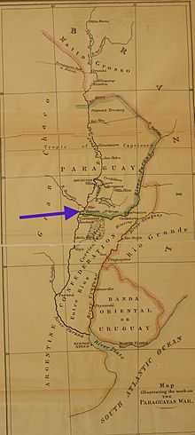
Paraguay is a landlocked country and for much of its history it was difficult of access, except by sailing up the River Paraguay (see map)[3] as the early Spanish explorers had done. There were other means of ingress, but they required travel through difficult and hostile country. Furthermore, as will now be described, past history had taught Paraguay to beware of its neighbours. So the command of the river was key to Paraguay’s security.
Anxiety about the Brazilian Empire
In a long history of conflicts between the empires of Portugal and Spain in America, the Portuguese made numerous incursions – some of them permanent – into Spanish-claimed territory. Slave raids by Bandeirantes from what is now Brazil into the Jesuit Reductions of Paraguay carried off many Guaraní inhabitants, who feared and despised the Brazilians.[4][5][6] The boundaries between the two empires were not resolved and the conflicts continued after independence, when Portuguese America became the Empire of Brazil.[7] Brazil had no practical access to its own territory of Matto Grosso except by sailing from the Atlantic Ocean up the River Paraguay (see map); fear that Paraguay might interfere with the navigation was a source of conflict.[8] Where Paraguay ended, and where the Matto Grosso began, was a matter of opinion.[9]
Anxiety about Buenos Aires
The Spanish Viceroyalty of the River Plate occupied an enormous territory roughly coterminous with the modern-day territories of Bolivia, central and northern Argentina[10], Paraguay and Uruguay. For a short time (1776-1810) the Spanish Viceroy had his seat in the city of Buenos Aires. Upon becoming independent from Spain the city claimed to be the capital of an identical territory it called the United Provinces of South America.[11] Other provinces – especially Bolivia, Uruguay and Paraguay – begged to differ and the Viceroyalty broke up in acrimony and warfare. In particular, Buenos Aires did not recognise the independence of Paraguay and in 1811 sent an army under General Belgrano to try to ‘recover’ it.[12] The Buenos Aires governor Juan Manuel Rosas during his dictatorship (1835-1852) tried to bring Paraguay to heel by closing the River Paraná to commercial traffic (see Battle of Vuelta de Obligado). Buenos Aires province fell out with the other provinces of Argentine Confederation and declared itself the independent State of Buenos Aires; it did not recognise Paraguay’s independence even after the others had. It was not until quite late in the nineteenth century (1859) that a re-united Argentina formally recognised an independent Paraguay. Even so the boundaries between Argentina and Paraguay were in dispute, notably the Chaco and Misiones territories.[13]
Defensive outlook of Paraguay
Upon its independence in 1811 Paraguay tried to keep out of the anarchy of adjoining Hispanic America. Its formidable dictator José Gaspar Rodríguez de Francia (1820-1840) imposed a strict policy of isolation. During his reign few were allowed to enter Paraguay, or to leave it.[14][15][16]
After his death he was succeeded by Carlos Antonio López, (called ‘López I’ by some authors,[17] a convenient if inaccurate designation), the father of Francisco Solano López (‘López II’). López I did open up Paraguay to foreign trade and technology,[18][19][20] but the steamship made his country vulnerable to invasion[21][22] and he understandably feared the machinations of his powerful neighbours.
During his presidency there were conflicts , not only with Brazil and Buenos Aires, but also the United States (the affair of USS Water Witch (1851) in which the fort of Itapirú fired upon an American warship)[23]. Although Carlos López was astute enough to know when to back down, he resolved to make Paraguay immune to foreign attack in future.
Immediate cause of its construction; initial works
In 1777, in colonial times, a modest ‘’guardia’’ (fortlet or lookout post) was established at Humaitá, a place about 15 miles above the mouth of the River Paraguay. However, a more formidable version was built in stages on the orders of López I. He started the work hurriedly in 1854 during conflict with Brazil over boundaries and navigation, when Paraguay was threatened by a Brazilian flotilla;[24]fortunately for López, the Brazilians were delayed by the low state of the river.[25]
To a design by the Hungarian colonel of engineers Wisner de Morgenstern,[26][27] he hastily fortified the river’s left bank with a few batteries, which were continually but slowly augmented, and a trench was dug on the land side enclosing the rear of them.[8]. He felled the virgin forest, leaving only a few scattered trees, grubbed up the roots, and laid out the first batteries, to whose completion some two years were devoted.[28] The works were supervised by British engineers, of whom there were a considerable number on contract to the government of Paraguay. [29]
Description of the finished fortress
Location
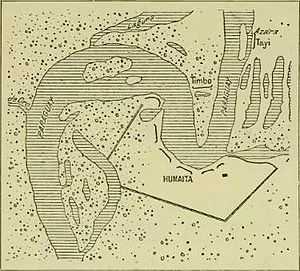
The bend in the river, called the ‘’’Vuelta de Humaitá’’’[30] was an ideal strategic pinch point. It was some 1500 metres long; the stream narrowed to only 200 metres broad; the current was 2.8 and in places 3 knots, difficult for the ships of the day to stem; and (a matter that was to horrify the Brazilian navy[31]) ideal for the release of ‘torpedoes' (nineteenth century floating naval mines.[32]
First impression
The explorer Captain Sir Richard Burton, who visited the scene during the war -- when the Brazilians were still dismantling the fortifications -- described it thus:[33]
The sweep is more than usually concave, to the benefit of gunnery and the detriment of shipping. Nothing more dangerous than this great bend, where vessels were almost sure to get confused under fire, as happened at Port Hudson to the fleet commanded by Admiral D. G. Farragut. The level bank, twenty to thirty feet above the river, and dipping in places, is bounded by swamps up-stream and down-stream. Earthworks, consisting of trenches, curtains and redans, disposed at intervals where wanted, and suggesting the lines of Torres Vedras, rest both their extremities upon the river, whose shape here is that of the letter U, and extend in gibbous shape inland to the south. The outline measures nearly eight miles and a half, and encloses meadow land to the extent of 8,000,000 square yards – a glorious battlefield.
>
Batteries
An invading force, if steaming around the bend upriver, would have to pass eight batteries, all capable of concentrating fire on the reentrant angle.
Preliminary batteries
First it had to pass the Humaitá redoubt, armed with a single 8” (20 cm calibre) gun.
It must then pass the Itapirú (seven guns); the Pesada [heavy] (five guns), all partly revetted with brick; the Octava or Madame Lynch[34] (three guns en barbette); the Coimbra (eight guns); and the Tacuarí (three guns).[35][36]
The ‘’’Batería Londres
Next, the invading flotilla must pass the Batería Londres (the London battery, so called because most of the ‘’técnicos’’ in Paraguay were recruited by the Limehouse firm of J. & A. Blyth). Its walls were 27 feet thick. It was supposed to be rendered bomb-proof by layers of earth heaped upon brick arches, and there were embrasures for 16 guns. “Of these ports” said Burton “eight were walled up and converted into workshops, because the artillerymen were in hourly dread of their caving in and crumbling down.”[35]
The ‘’’Batería Cadenas’’ and the chain boom
As a climax the invading force would come alongside the ‘’Bateria Cadenas’’ (Chain battery), backed by the Artillery Barracks. The boom across the river, which consisted of seven chains twisted together, passed diagonally through a kind of brick tunnel. It was made fast to a windlass supported by a house about 100 yards from the bank. Nearer the battery stood a still larger capstan: however, Burton noted that it lacked force to haul taut the chain. [37]
Landward defences: the Quadrilateral
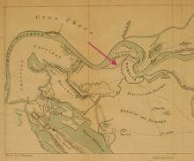
The Paraguayans had not neglected to take precautions against Humaitá being seized from the landward side. To prevent this, an elaborate system of trenches was constructed, extending over 8 miles, known as the Polígono or Quadrilateral. Every part of it that was not naturally impassable lagoon or ‘’carrizal’’ (impenetrable reed beds growing in swamp) was protected by a trench, in which artillery could be deployed.
Burton reported that the layout required a garrison of at least 10,000 men.
Electrical telegraphy
In the final stages of the fortifications electrical telegraph lines were laid out from Humaitá and the points in the Polígono to López II’s headquarters at Pasó Pucú; and he could instantly be informed -- in Morse code -- of an enemy attack on any point. The English military engineer George Thompson, a colonel in the Paraguayan army, recorded that the Guaraní were adept telegraphists.[38]
Strategic significance and perception
Michael Mulhall, editor of the Buenos Ayres Standard, passed the site in 1863 and reported it to the world in these terms:[39][40]
A succession of formidable batteries which frowned on us as we passed under their range… [A]ny vessel, unless iron-plated, attempting to force a passage must be sunk by the raking and concentrated fire of this fortification, which is the key to Paraguay and the upper rivers.
When López I built Humaitá all warships were made of wood, and steamships were mostly paddle-driven. (The first ironclad vessel was not launched until 1859, in France). It was not clear how wooden paddle-steamers were supposed to steam past the batteries – which, at a range of 200 metres at the very most, could hardly miss – against the current, and somehow cut through the boom of seven twisted chains, without being sunk.
A modern appreciation by Professor Whigham:[41]
As a strategic site, Humaitá was without equal in the region, for enemy ships could not ascend the Paraguay [river] without passing under its guns. It was also exceptionally well protected on the south and east by marshes and lagoons.
Weaknesses
Ironically, Humaitá was not as impregnable as was generally supposed.
Defective weaponry
Although Paraguay could and did manufacture large artillery guns, there was nevertheless a shortage -- partly because guns had to be taken to reinforce the landward artillery -- [42] and not all of the guns at Humaitá were of acceptable standard. When Burton inspected them (August 1868) he noted that many had been thrown into deep water but the remainder were poor:[43]
The guns barely deserve the name; some of them were so honeycombed that they must have been used as street posts...[44] Not the worst of them were made at Asunción or Ibicuy, whose furnaces and air chimneys could melt four tons per diem. Some had been converted, but it was a mere patchwork. A few rifled 12-pounders had been cast at Asunción. There were sundry old tubes bearing the arms of Spain; two hailed from Seville, the San Gabriel (A.D. 1671) and the San Juan de Dios (1684).
Defective fortifications
According to Burton [45] the system of fortification lacked the latest developments, instead using the obsolete en barbette system which failed to protect the defending artillerymen. The consequence:
Thus the works were utterly unfit to resist the developed powers of rifled artillery, the concentrated discharge from shipping, and even the accurate and searching fire of the Spencer carbine. The Londres work, besides being in a state of decay, was an exposed mass of masonry which ought to have shared the fate of forts from Sumpter to Pulaski, and when granite fails bricks cannot hope to succeed. Had the guns been mounted in Monitor towers, or even protected by sand-bags, the ironclads would have suffered much more than they did in running past them.
Obsolescence
López I fortified Humaitá in the era of the wooden paddle-steamer warship. The first ironclad warship was not launched until 1859 and that was in France; it could not have navigated the shallow waters of the River Paraguay; and no battles between European ironclads had actually happened.
However, the American Civil War (1861-1865) had brought forth a demand for heavily armoured vessels that could navigate in river waters: and it demonstrated their dramatic power. Apart from the more conventional ironclads, which the Brazilian navy could order from Britain or France, the Americans had invented the monitor, a heavily armoured, shallow draft vessel that presented little superstructure to enemy fire; monitors could be and were built in Brazil. Thus by the time Lopez II fired the first shots against Brazil (December 1864) the Humaitá defences were obsolescent to the latest naval weaponry that could be purchased. Brazil was an enormous country and after the war broke out it could have (and soon did have) 20 ironclads.
Unintended consequences
The Humaitá defensive system was built to increase the security of Paraguay. Paradoxically, its strength – real or perceived -- may have had unintended consequences. For Brazil and Argentina the fortifications changed the balance of advantage in the region, and posed a potential threat to their own security. Lt Colonel George Thompson of the Paraguayan army noted that:
These batteries commanded the whole bend of the river, and Paraguay made all vessels anchor and ask permission before they could pass up the river. As this was the only practicable road which Brazil had to her province of Matto-Grosso, she naturally disapproved of her stoppage of the river, and gradually accumulated large military stores in Matto-Grosso, with the view, no doubt, of some day destroying Humaitá.”
Further, and on a traditionally held view, it produced a perverse incentive. To the extent that López II felt himself to be invulnerable it increased his hubris.[46] On that view, after the death of his father, the cautious López I, the son paid not enough attention the father’s dying words – to try to settle disputes with Brazil with the pen not the sword.[47] He was lured, by a faction, to intervene in a conflict in the River Plate region; and he fired the first shot on the Brazilian government ship ‘’Marques de Olinda’’.[48] Not content, he soon fired upon an Argentine naval vessel in the city of Corrientes and seized the province of that name.[49]. The resulting War was to destroy his country.
See also
Francisco Solano Lopez
Notes
- ↑ The number enrolled in the Brazilian National Guard was said (by Williams, 1979, ch. 13) to exceed the total population of Paraguay.
- ↑ Protocol to the Treaty of Alliance against Paraguay, 1 May 1866, article 1.
- ↑ The map was published in Thompson, 1879, Plate VIII.
- ↑ Francis, p. 130.
- ↑ Bakewell, p. 427.
- ↑ Sarreal, p. 32.
- ↑ Whigham, pp. 14-17.
- ↑ 8.0 8.1 Thompson, p. 16.
- ↑ Whigham, pp. 78-92.
- ↑ It also claimed Patagonia, Tierra del Fuego and the Falkland Islands (Malvinas).
- ↑ Still an official name of Argentina today: Constitution of Argentina, Article 35.
- ↑ Whigham, pp. 30-31.
- ↑ Whigham, pp. 93-117.
- ↑ Thompson, pp. 4-5.
- ↑ Washburn, pp. 267-269.
- ↑ Wigham, pp. 36-41.
- ↑ For example, Thompson
- ↑ Whigham, pp. 68-69.
- ↑ Thompson, pp. 10-11.
- ↑ Williams, 1971, chs. 6-7.
- ↑ Kray, p. 38.
- ↑ Sailing vessels could take 6 months to sail from Buenos Aires to Humaitá: Burton, 295
- ↑ Washburn, pp. 364-376.
- ↑ Burton 63.
- ↑ Page 109.
- ↑ Burton, p. 315.
- ↑ Williams 1979, chapter 11.
- ↑ Burton, p. ?.
- ↑ Plá.
- ↑ Humaitá bend.
- ↑ Burton, p. 332.
- ↑ Burton, p. 313.
- ↑ Burton, pp. 314-315.
- ↑ Eliza Lynch was López II’s mistress.
- ↑ 35.0 35.1 Burton, p. 319.
- ↑ Burton in describing the batteries examined them from the landward side walking in the downstream direction. In this Article the direction is reversed, as they would be encountered by an invading naval force.
- ↑ Burton 318-319.
- ↑ Thompson, p. 155.
- ↑ Mulhall, p. 84.
- ↑ And quoted in Burton, 315-316.
- ↑ Whigham 185.
- ↑ Thompson, p. 191.
- ↑ #CITEREF.
- ↑ In Europe defective cannon were often used as street posts; some of these may have been imported into South America as ballast.
- ↑ Burton, p. 320.
- ↑ According to the American ambassador Charles A. Washburn (Washburn, p.563), Lopez told him "with more candor than discretion" that only by a war could the attention and respect of the world be secured to Paraguay.
- ↑ Whigham, p. 92.
- ↑ Whigham, p. 160.
- ↑ Whigham, pp. 259-307.
Sources
- Bakewell, Peter (2010). A History of Latin America to 1825, 3rd ed. United Kingdom: John Wiley & Sons. ISBN 978-1-4051-8368-0.
- Burton, Captain Sir Richard (1870). Letters From the Battle-Fields of Paraguay. London: Tinsley Brothers.
- Francis, John Michael (2006). Iberia and the Americas, volume 1. ABC-CLIO. ISBN 1851094210.
- Kray, Hendrik (2004). I Die With My Country:Perspectives on the Paraguayan War, 1864-1870. University of Nebraska Press. ISBN 0803227620.
- Mulhall, M. G.; Mulhall, E. T. (1863). Handbook of the River Plate. Buenos Aires: The Standard Printing Office.
- Page, Thomas Jefferson (1859). La Plata, the Argentine Confederation and Paraguay. London: Trubner & Co.
- Plá, Josefina (1976). The British in Paraguay 1850-1870. The Richmond Publishing Co in association with St Antony’s College, Oxford.
- Thompson, George (1869). The War In Paraguay: With a Historical Sketch of the Country and Its People and Notes Upon the Military Engineering of the War. London: Longman’s, Green and Co. (Note: Not all bound copies of this important source book have a complete set of maps. A scanned version of a good copy at the Boston Public Library was accessed at the Internet Archive on 29 April 2015.)
- Sarreal, Julia (2014). The Guaraní and Their Missions: a socioeconomic history. Stanford University Press. ISBN 9780804785976.
- Washburn, Charles (1871). The History of Paraguay: With Notes of Personal Observations, and Reminiscences of Diplomacy Under Difficulties, vol. 1. Boston: Lee and Shephard.
- Whigham, Thomas L. (2002). The Paraguayan War, Volume 1, Causes and Conflict. Lincoln and London: University of Nebraska Press. ISBN 0-8032-4786-9.
- Williams, John Hoyt (1979). The Rise and Fall of the Paraguayan Republic, 1800-1870. Austin, Texas: Institute of Latin American Studies; The University of Texas Press. ISBN 0-292-77017-0.