Fortifications of Zürich
Zurich was an independent (reichsfrei) city or city-state from 1218 to 1798. The town was fortified with a city wall from the 13th to the 17th century, and with more elaborate ramparts constructed in the 17th to 18th century and mostly demolished in the 1830s to 1870s.
First wall
There had been a first city wall dating to the 11th or 12th century. The existence of such an early wall had been suggested, but the mainstream view assumed that the town had been unfortified – the remains of the Roman castle at the Vicus Turicum, and a so-called Kaiserpfalz on Lindenhof hill excepted – before the 13th century, until the chance discovery of remnants of the first wall during the 1990s construction work at the central library respectively location of the Predigerkloster, the former Dominican abbey.
Second wall
Following the extinction of the main line of the Zähringer family in 1218, Zurich became a free imperial city. Over the following decades, a city wall was constructed over a length of some 2,400 m.
-

1485 depiction of the 1444 siege of Zurich during the Old Zurich War (north is right)
-

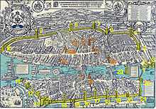
1581 depiction of Zurich (north is left)
-
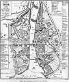
1904 map of Zurich in 1504
-
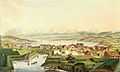
Schanzengraben, Enge quarter, Zürichsee and Albis chain, as seen from the «zur Katz» ramparts (as of today the "old" Botanical Garden)
-

Remains of the medieval city walls in a basement of Zentralbibliothek Zürich respectively at the location of today's Predigerkirche
-
The Rennweg gate in 1812
-

The Oetenbach bulwark (built 1532) just before its demolition in 1903
-

Bilgeri tower at Neumarkt
-

Brunnenturm (fountain tower) near Niederdorf
-

Glentner tower at Limmatquai
-

Grimmenturm at Neumarkt
-

Hardturm at Limmat river (Industriequartier)
-

Mülnerturm or Schwert house at Weinplatz (Rathausbrücke)
-

Steinhaus at Hirschengraben
Early modern ramparts


From 1642, an impressive set of ramparts was built based on plans by Hans Georg Werdmüller and Johann Ardüser, at an immense cost and completed only in the second half of the 18th century. The ramparts included fifteen bastions, one of them built inside the Limmat river (the Bauschänzli, location of the former Ravelin Kratz).
The ramparts were mostly destroyed in 1834, but parts of the walls and the western moat remain visible.
-

1793 map of Zurich (north is left), the so-called Müllerplan
-

The moat (Schanzengraben) and the remains of the bastion zur Katz (Old Botanical Garden), next to Selnau station.
-

18th century sketch of the old and new walls on either side of Paradeplatz (at the time known as Neuer Markt).
-
.JPG)
Stadelhoferbastion and former war harbour at, as of today, Sechseläutenplatz and Stadelhoferplatz
See also
| Wikimedia Commons has media related to Fortifications of Zürich. |