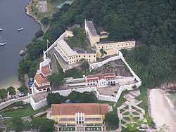
Fortaleza de São João (Rio de Janeiro)
| Fortaleza de São João | |
|---|---|
| Rio de Janeiro, RJ, Brazil | |
|
Fortaleza de São João, seen from Sugarloaf Mountain | |
| Type | Star fort |
| Site information | |
| Owner | Brazilian Armed Forces |
| Open to the public | Yes |
| Condition | Intact |
| Site history | |
| Built | 1565 |
| Built by |
Sebastian I of Portugal |
| In use | 1565-1991 |
The Fortaleza de São João da Barra do Rio de Janeiro (Portuguese for: Fortress of Saint John of the Harbor of Rio de Janeiro), popularly known as the Fortaleza de São João or Forte (de) São João (Fort (of) Saint John), is a 16th-century star fort in the present-day Urca neighborhood of Rio de Janeiro, erected by Estácio de Sá to protect Guanabara Bay from French invasion.[1]
History
The original fort was built in 1565 under King Sebastian of Portugal. An expanded and improved structure was put into service in 1618, consisting of four batteries (São José, São Martinho, São Teodósio, and São Diogo). Its armaments were greatly reduced, and not manned, during Brazil's Regency period, but Dom Pedro II ordered the fort completely renovated in 1872, and it was equipped with a complement of guns, bunkers, and batteries, including fifteen Whitworth cannons. It was manned as a coastal artillery installation until 1991.[1]
In 1930, the Brazilian Army's Centro Militar de Educação Física (created in 1922) was transferred to the Fortaleza de São João. This establishment was renamed Escola de Educação Física do Exército in 1933[2] and continues to be based at the Fortaleza de São João, together with the directorate to which it is subordinated, the Diretoria de Pesquisa e Estudos de Pessoal , since the latter's creation in 2002.[3]
Notes
- ↑ 1.0 1.1 Fundação Cultural Exército Brasileiro , Espaço Cultural: Fortaleza de São João, RJ
- ↑ The EsEFEx: Words from the Comandante (instructor supervisor's manual)
- ↑ DPEP/FSJ: Histórico
External links
- Map of the Situation of the Three Main Fortresses on the Inlet Entrance of Rio de Janeiro... is a map from 1764 including Fortaleza de São João and two other forts. (English) (Portuguese)
Coordinates: 22°56′36″S 43°09′23″W / 22.943372°S 43.156458°W
