Fort William, Scotland
| Fort William | |
| Scottish Gaelic: An Gearasdan | |
| Scots: Fort Weelum | |
 Fort William High Street |
|
 Fort William |
|
| Population | 9,908 (2001 Census) |
|---|---|
| OS grid reference | NN103738 |
| Council area | Highland |
| Lieutenancy area | Inverness |
| Country | Scotland |
| Sovereign state | United Kingdom |
| Post town | FORT WILLIAM |
| Postcode district | PH33 |
| Dialling code | 01397 |
| Police | Scottish |
| Fire | Scottish |
| Ambulance | Scottish |
| EU Parliament | Scotland |
| UK Parliament | Ross, Skye and Lochaber |
| Scottish Parliament | Inverness East, Nairn & Lochaber |
Coordinates: 56°49′01″N 5°06′35″W / 56.81689°N 5.10963°W
Fort William (Scottish Gaelic: An Gearasdan [ən ˈkʲɛrəs̪t̪ən] "The Garrison") is the second largest settlement in the Highlands of Scotland with around 10,000 inhabitants — and the largest town: only the city of Inverness is larger.
Fort William is a major tourist centre, with Glen Coe just to the south, Aonach Mòr to the north and Glenfinnan to the west, on the Road to the Isles. It is a centre for hillwalking and climbing due to its proximity to Ben Nevis and many other Munro mountains. It is also known for its nearby downhill mountain bike track. It is the start/end of both the West Highland Way (Milngavie-Fort William) and the Great Glen Way (a walk/cycle way Fort William-Inverness).
Around 726 people (7.33% of the population) can speak Gaelic.[1]
Etymology
Questions over the town's English name are various. The post-Reformation fort was named Fort William after William of Orange, and the settlement that grew around it was called Maryburgh, after his wife. This settlement was later renamed Gordonsburgh, and then Duncansburgh[2] before being renamed Fort William, this time after Prince William, Duke of Cumberland; known to some Scots as "Butcher Cumberland". Given these origins, there have been various suggestions over the years to rename the town (for example, to Invernevis). These proposals have led to nothing yet.
Questions over the town's Gaelic name are equally interesting. The Gaelic name for the town is An Gearasdan, and this is the result of a transliteration from the French term Garrison. French loan-words in the Gaelic language are very rare, and can only correspond with specific times in Scottish history: during David I's politically pacifying introduction of a Norman aristocracy in Scotland after the Norman conquest of England, and the period covering the Auld Alliance.
The most likely derivation for the town's Franco-Gaelic name is from the Scoto-Norman Clan Comyn, who built Inverlochy Castle in the Norman style that is familiar throughout Scotland during this period. French loan-words that take root during the Auld Alliance are far more common in the Scots language than in Gaelic.
History
Historically, this area of Lochaber was strongly Clan Cameron country, and there were a number of mainly Cameron settlements in the area (such as Blarmacfoldach). The nearby settlement of Inverlochy was the main settlement in the area before the building of the fort, and was also site of the Battle of Inverlochy.

The town grew in size as a settlement when the fort was constructed to control the population after Oliver Cromwell's invasion during the English Civil War, and then to suppress the Jacobite uprisings of the 18th century.
In the Jacobite rising known as the Forty-Five, Fort William was besieged for two weeks by the Jacobites, from 20 March to 3 April 1746. However, although the Jacobites had captured both of the other forts in the chain of three Great Glen fortifications (Fort Augustus and the original Fort George) they failed to take Fort William.
During the Second World War, Fort William was the home of HMS St Christopher which was a training base for Royal Navy Coastal Forces.
More on the history of the town and the region can be found in the West Highland Museum on the High Street.

Fort William is the northern end of the West Highland Way, a long distance route which runs 95 miles (153 km) through the Scottish Highlands to Milngavie, on the outskirts of Glasgow, and the start/end point of the Great Glen Way, which runs between Fort William and Inverness.
On 2 June 2006, a fire destroyed McTavish's Restaurant in Fort William High Street along with the two shops which were part of the building. The restaurant had been open since the 1970s and prior to that the building had been Fraser's Cafe since the 1920s. Development work began in 2012 on new hotel accommodation and street-level shops. It is unclear when this project will be completed.
Future development
A "Waterfront" development has been proposed by the Council though there is not overwhelming support for this in the town.[3] The development will include a hotel, some shops and some housing but it was discovered early in 2008 that it is unlikely to be completed before 2020.[4] It was announced in April 2010 that the project has been abandoned.[5]
Geography

Fort William lies near the head of Loch Linnhe, one of Scotland's longest sea lochs, beside the mouth of the rivers Nevis and Lochy. They join in the intertidal zone to briefly become one river before discharging to the sea. The town and its suburbs are surrounded by picturesque mountains.
The town is centred on the High Street, which was pedestrianised in the 1990s. Off this there are several squares. Monzie Square (named after the Cameron Campbells of Monzie, Perthshire, former landowners in the town), Station Square, where the long-since demolished railway station used to be, Gordon Square (named for the Gordons, who owned land where the town now stands in the late 18th century, during which time the town was named Gordonsburgh), and Cameron Square — formerly known as Town Hall Square. There is also Fraser Square which is not so square-like since it now opens out into Middle Street but it still houses the Imperial Hotel.
The main residential areas of the town are unseen from the high street or the A82 main road. Upper Achintore and the Plantation spread steeply uphill from above the high street.
Inverlochy, Claggan, An-Aird, Lochyside, Caol, Banavie and Corpach outwith the town are the other main residential areas. These areas are built on much flatter land than the town.
Glenfinnan, 17 miles (27 km) away, is home of the Glenfinnan Monument (Jacobite era) and the famous Glenfinnan Viaduct (as seen on a Bank Of Scotland £10 note[6]). The viaduct has become known to millions in recent years as the "Harry Potter Bridge" after it featured in the films of the books by J.K. Rowling, specifically Harry Potter and the Chamber of Secrets. Glenfinnan has also been used in Charlotte Gray and Highlander.
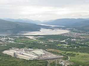
Just outside the town is a large aluminium plant operated by Alcan and powered by the Lochaber hydroelectric scheme,[7] in its day the biggest tunnelling project in the world. This was formerly served by the Lochaber Narrow Gauge Railway better known locally as the Puggy Line.
Location
Originally based on the still-existent village of Inverlochy, the town lies at the southern end of the Great Glen, on the shores of Loch Linnhe and Loch Eil. It is close to Ben Nevis, the highest mountain in the British Isles, and Glen Nevis. When the railway opened to Fort William on 7 August 1894, the station was given prime position at the south end of the town. The consequence was that the town was separated from the lochside by railway tracks until the 1970s when the present by-pass was built, and the station was re-located to the north end.
 |
Mallaig, Portree, Shiel Bridge | Kyle of Lochalsh, Ullapool | Spean Bridge, Invergarry, Fort Augustus, Inverness | |
| Glenfinnan, Lochailort, Arisaig | |
Roybridge, Dalwhinnie, Aberdeen | ||
| ||||
| | ||||
| Inchree, Oban | Ballachulish, Inveraray, Dunoon | Bridge of Orchy, Crianlarich, Glasgow |
Climate
Fort William has an oceanic climate (Cfb) with moderate, but generally cool, temperatures and abundant precipitation.
| Climate data for Fort William, United Kingdom | |||||||||||||
|---|---|---|---|---|---|---|---|---|---|---|---|---|---|
| Month | Jan | Feb | Mar | Apr | May | Jun | Jul | Aug | Sep | Oct | Nov | Dec | Year |
| Average high °C (°F) | 5.0 (41) |
5.0 (41) |
8.0 (46.4) |
10.0 (50) |
14.0 (57.2) |
17.0 (62.6) |
18.0 (64.4) |
18.0 (64.4) |
15.0 (59) |
11.0 (51.8) |
8.0 (46.4) |
6.0 (42.8) |
11.3 (52.25) |
| Average low °C (°F) | −1.0 (30.2) |
−1.0 (30.2) |
1.0 (33.8) |
3.0 (37.4) |
7.0 (44.6) |
10.0 (50) |
11.0 (51.8) |
11.0 (51.8) |
8.0 (46.4) |
5.0 (41) |
2.0 (35.6) |
1.0 (33.8) |
4.8 (40.55) |
| Average rainfall mm (inches) | 216.0 (8.504) |
146.0 (5.748) |
173.0 (6.811) |
101.0 (3.976) |
89.0 (3.504) |
100.0 (3.937) |
122.0 (4.803) |
130.0 (5.118) |
171.0 (6.732) |
200.0 (7.874) |
197.0 (7.756) |
238.0 (9.37) |
1,883 (74.133) |
| Source: Weather 2 Travel[8] | |||||||||||||
Transport
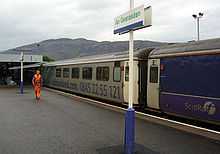
The West Highland Line passes through Fort William. Owing to the difficult terrain in the area, the line from Glasgow, to the south, enters from the northeast. Trains from Glasgow to Mallaig, the terminus of the line, have to reverse at Fort William railway station.[9]
An overnight train, the Caledonian sleeper, has its terminus at Fort William. This service is known colloquially as 'The Deerstalker'.
A bus station outside the railway station is served by local buses and express coaches.
The Caledonian Canal connects the Scottish east coast at Inverness with the west coast at Corpach near Fort William.
Sports
Mountain biking
Just outside the town, parallel to the Nevis Range Gondola, there is a large downhill mountain bike track which attracts thousands of visitors every year, including international competitors and fans.
Each year since 2001, Fort William has hosted a round of UCI Mountain Bike World Cup, and in 2007 it hosted the UCI Mountain Bike & Trials World Championships ('The Worlds'). Also a trials competition is held, at the various courses at the bottom.
Winners of key men's downhill events at Fort William are:
- 2007 'The Worlds': Sam Hill. Time: 4:51 minutes.
- 2008 World Cup: Greg Minnaar.
- 2009 World Cup: Greg Minnaar. Time: 4:38:98 minutes.[10]
- 2010 World Cup: Gee Atherton.
- 2013 World Cup: Gee Atherton.
- 2014 World Cup: Troy Brosnan.
Winners of key women's downhill events at Fort William are:
- 2008 World Cup: Tracey Mosely.
- 2009 World Cup: Sabrina Jonnier. Time: 5:17:65 minutes.[11]
- 2013 World Cup: Rachel Atherton.
- 2014 World Cup: Emmeline Ragot.
Winners of key women's 4-cross events at Fort William are:
Motorcycle trials
Fort William is the home of the Scottish Six Day Motorcycle Trial (SSDT), held annually in the first full week of May. It attracts many competitors from all across the globe and in 2011 the event celebrated its centenary year.
Shinty
Fort William has two major shinty teams, Fort William Shinty Club and Kilmallie Shinty Club.
Football
The town also has a football team, Fort William F.C., competing in the Scottish Highland Football League. They play their home games at Claggan Park.
Rugby
Fort William is the home of Lochaber Rugby Club.
Sailing
The Lochaber Yacht Club on Achintore Road, Fort William is a Community Amateur Sports Club and was founded in 1954.
As a film location
Movies filmed in or near Fort William include Being Human, Braveheart, Highlander, Restless Natives, the Harry Potter series and Rob Roy. The TV series Rockface was filmed mainly around Fort William and some scenes of Monarch of the Glen were filmed around Lochaber although mostly near Newtonmore. Local Hero shot the internal Houston scenes in Fort William.
Festival
In a celebration of mountains and the culture that surrounds them, and in recognition of the importance of climbing and walking tourism to the town, the Fort William Mountain Festival is held there each year. For a number of years, this volunteer-led festival has concentrated mostly around film but, starting in the Year of Highland Culture - Highland 2007, its scope was widened, and it dropped the word 'film' from its title.[13]
Education
Lochaber High School is the local high school and serves a large catchment area which includes the surrounding villages. The town itself is served by three primary schools, one of which is a Catholic school.
Notable people
- Hugh Cochrane, recipient of the Victoria Cross
- Charles Kennedy - Former leader of the Liberal Democrat party and current Liberal Democrat Member of Parliament for Ross, Skye and Lochaber. Although born in Inverness, was brought up and educated in Fort William.
- Danny Alexander - The current Chief Secretary to the Treasury and Liberal Democrat Member of Parliament for Inverness, Nairn, Badenoch and Strathspey. Brought up in Invergarry, a small village just outside Fort William.
- Justin Ryan - interior decorator and television presenter, although born in Glasgow, was brought up in Fort William.
- Allan MacDonald - Roman Catholic priest, Scottish Gaelic scholar, and pastor in South Uist and Eriskay, was born and brought up in Fort William.
- Daniel McLean McDonald - Founder of the BSR company and benefactor of the McDonald Institute for Archaeological Research in the University of Cambridge.[14]
- John Wood, recipient of the Victoria Cross
- Jack Macmillan, Spoken Word Artist
Notes
- ↑ "Gàidhlig (Scottish Gaelic) Local Studies" (PDF). Population figures. September 2006. Retrieved April 7, 2012.
- ↑ "Faddoch (Ross), An Fhàdaich" (PDF). Retrieved 2009-07-30.
- ↑ "Lochaber News". Lochaber News. Retrieved 2009-07-30.
- ↑ "Lochaber News 12 January 2008". Lochaber-news.co.uk. 2008-01-12. Retrieved 2009-07-30.
- ↑ £80m Fort William waterfront project falls through, Page last updated at 10:50 GMT, Tuesday, 20 April 2010 11:50 UK
- ↑ http://www.scotbanks.org.uk/banknoteapp/BoS_10.html
- ↑ "Wonders of Water Power — Aluminium Production". Mercedes-w123.net. Retrieved 2009-07-30.
- ↑ "Climate data for Fort William". Weather 2 Travel. Retrieved 2012-04-07.
- ↑ "West Highland Railway". Railscot. Retrieved 2009-07-30.
- ↑ "Mountain Bike World Cup: Minaar strikes again at Fort William - Scotsman.com Sport". Retrieved 2010-09-16.
- ↑ "Official UCI women's downhill results, 2009, Fort Williams". Uci.ch. Retrieved 2009-07-30.
- ↑ "Official UCI women's 4-cross results, 2009, Fort Williams". Uci.ch. Retrieved 2009-07-30.
- ↑ Fort William Mountain Festival. Retrieved from http://www.mountainfilmfestival.co.uk/.
- ↑ "McDonald Institute for Archaeological Research in the University of Cambridge". Mcdonald.cam.ac.uk. Retrieved 2009-07-30.
References
- MacCulloch, Donald B. (1971). Romantic Lochaber. Chambers. ISBN 0-550-50347-1.
External links
| Wikivoyage has a travel guide for Fort William. |
| Wikimedia Commons has media related to Fort William, Scotland. |
- Fort William walks and outdoors guide
- Fort William the End of the West Highland Way
- Map of Ft William and area, dated 1710
- History of HMS St Christopher
 "Fort William, a police burgh of Inverness-shire, Scotland". Encyclopædia Britannica (11th ed.). 1911.
| ||||||||||||||||||