Fort Recovery
|
Fort Recovery Site | |
 | |
|
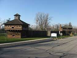
Walls at the reproduction of Fort Recovery | |
 | |
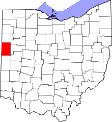
| Location | State Route 49, Fort Recovery, Ohio |
|---|---|
| Coordinates | 40°24′50″N 84°46′51″W / 40.41389°N 84.78083°WCoordinates: 40°24′50″N 84°46′51″W / 40.41389°N 84.78083°W |
| Area | 5 acres (2.0 ha) |
| Built | 1791 |
| Governing body | State |
| NRHP Reference # | 70000509[1] |
| Added to NRHP | November 10, 1970 |
Fort Recovery was a United States Army fort begun in late 1793 and completed in March 1794 under orders by General "Mad" Anthony Wayne. It was located on the site of the present-day village of Fort Recovery, Ohio, United States, on the Wabash River within two miles of the boundary with Indiana.
Wayne purposely chose as the location for his new fort the spot where Arthur St. Clair had been defeated in 1791 by a Native American confederacy under Miami Chief Michikinikwa (Little Turtle) and Shawnee Chief Weyapiersenwah (Blue Jacket). That battle, called St. Clair's Defeat, ended St Clair's military career and prompted the United States Congress to undertake a full investigation of the loss. Wayne hoped to demonstrate that the United States Army could recover from this crushing defeat and emerge victorious in what is now termed the Northwest Indian War or "Little Turtle's War."
Attack on Fort Recovery

On June 30, 1794, a supply column left Fort Recovery for Fort Greenville, under the command of Major William McMahon and escorted by ninety riflemen under Captain Asa Hartshome and fifty dragoons under Lieutenant Edmund Taylor. It had only gone about a quarter mile when it was attacked by a Native American force, commanded by Blue Jacket and including a young Tecumseh.[2] The dragoons cut a retreat back to the fort, but thirty-two men were killed, including Captain Hartshome and Cornet Daniel Torrey. Thirty more men were wounded. An unknown number of Native Americans were killed.
During the night, a scouting company under Captain William Wells reported that there were British officers behind the American Indian lines, and that they had brought powder and cannonballs, but no cannons. The Native Americans were looking for U.S. cannons that had been buried after St. Clair's Defeat, not knowing that they had already been recovered by the Legion of the United States. The next day, July 1, 1794, the Native American forces attacked the fort again, but began to withdraw by noon and were gone by nightfall.[3]
Fort Recovery was a reference point used to define the boundary line established in the Treaty of Greenville in 1795, following Wayne's victory in the Battle of Fallen Timbers. In 1800, it was used as a reference point in defining the initial boundaries of the Indiana Territory when that was first set off from the original Northwest Territory. When Ohio was admitted as a state in 1803, the boundaries had been adjusted and Fort Recovery was not mentioned as a reference point for the boundaries of the state.
Fort Recovery Memorial

In 1891, the battle sites were excavated, and the remains of some 1200 people were buried in a memorial park downtown. In 1908, President William Howard Taft signed a bill that allowed for the building of a monument for those killed under the command of Arthur St. Clair and Anthony Wayne in Fort Recovery. In 1910, he gave Fort Recovery $25,000 to build the monument. The monument, in the form of an obelisk, was built in 1912 and dedicated on July 1, 1913. The obelisk stands at 101', 4" tall. It weighs approximately 800 tons and cost $23,700 to build. Today that monument is part of a historical landmark known as Fort Recovery State Memorial that is maintained by the Ohio Historical Society. Visitors can enjoy touring a replica of Wayne's fort with two reconstructed blockhouses with a connecting stockade. The replica is not in the same location where the original forts were, but they are in the process of relocating where they once stood.

The Fort Recovery State Museum, opened in 1938, features life-size dioramas of fort soldiers and a typical Native American from the 1790s. Exhibits explain Wayne's campaign and include military and Native American artifacts, uniforms, weapons, paintings and maps. The museum features a gift shop and offers programs for school groups.
References
- ↑ "National Register Information System". National Register of Historic Places. National Park Service. 2009-03-13.
- ↑
- Allison, Harold (©1986, Harold Allison). The Tragic Saga of the Indiana Indians. Turner Publishing Company, Paducah. p. 108. ISBN 0-938021-07-9. Check date values in:
|date=(help)
- Allison, Harold (©1986, Harold Allison). The Tragic Saga of the Indiana Indians. Turner Publishing Company, Paducah. p. 108. ISBN 0-938021-07-9. Check date values in:
- ↑
- Allison, Harold (©1986, Harold Allison). The Tragic Saga of the Indiana Indians. Turner Publishing Company, Paducah. pp. 108–110. ISBN 0-938021-07-9. Check date values in:
|date=(help)
- Allison, Harold (©1986, Harold Allison). The Tragic Saga of the Indiana Indians. Turner Publishing Company, Paducah. pp. 108–110. ISBN 0-938021-07-9. Check date values in:
External links
- Historic Fort Recovery
- Fort Recovery on Ohio Historical Society site
- Fort Recovery State Museum
- Act creating Indiana Territory
- U.S. Geological Survey Geographic Names Information System: Fort Recovery
| |||||||||||||||||
| ||||||||||||||||||||||||||
