Fort Pownall Memorial
|
Fort Pownall Memorial | |
 | |
|
Ruins of Fort Pownall | |
 | |
| Nearest city | Stockton Springs, Maine |
|---|---|
| Coordinates | 44°28′5″N 68°48′46″W / 44.46806°N 68.81278°WCoordinates: 44°28′5″N 68°48′46″W / 44.46806°N 68.81278°W |
| Built | 1759 |
| Architectural style | No Style Listed |
| Governing body | State |
| NRHP Reference # | 69000028[1] |
| Added to NRHP | October 28, 1969 |
The Fort Pownall Memorial is located in Maine's 120-acre (0.49 km2) Fort Point State Park. The park is located on Fort Point, a small peninsula running eastward from Cape Jellison.[2]
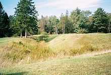
Remains of fortifications
In 1760, during the French and Indian War, Massachusetts governor Thomas Pownall led the construction of a fort here, which he named Fort Pownall after himself. It was intended to secure the area for European settlement by driving off the remaining Norridgewock and Penobscot Indians. Commander of the fort was Jedidiah Preble.[3] No battles ever took place at the fort. In 1775, British forces seized the cannons and powder. Later, a regiment of continental soldiers burnt the blockhouse and filled-in most of the ditches to prevent their use by the British.[4]
See also
References
- ↑ "National Register Information System". National Register of Historic Places. National Park Service. 2007-01-23.
- ↑ "Fort Point State Historic Site". State of Maine, Department of Conservation, Bureau of Parks & Land. Retrieved 2008-04-07.
- ↑ http://archive.org/stream/genealogicalsket00preb#page/n73/mode/2up
- ↑ "Fort Pownall". State of Maine, Department of Conservation, Bureau of Parks & Land. 2004-12-02. Retrieved 2007-11-04.
| ||||||||||||||||||||||||||