Fort O'Brien
|
Fort O'Brien | |
 | |
|
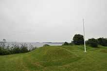
View of fort remains: Revolutionary War on the left, Civil War on the right | |
 | |
| Nearest city | Machiasport, Maine |
|---|---|
| Coordinates | 44°41′22″N 67°23′48″W / 44.68944°N 67.39667°WCoordinates: 44°41′22″N 67°23′48″W / 44.68944°N 67.39667°W |
| Area | 0 acres (0 ha) |
| Built | 1775 |
| Governing body | State |
| NRHP Reference # |
69000024 [1] |
| Added to NRHP | October 01, 1969 |
Fort O'Brien State Historic Site, also known as Fort Machias, preserves the remains of a fort located in Machiasport, Maine that was built and destroyed three times over a 90-year period.

The Civil War batteries
The first fort was built in 1775 to guard the Machias River and its communities, and destroyed by the British during the American Revolutionary War in the same year. The fort was rebuilt in 1777, and then destroyed by the British in 1814 during the War of 1812. Gun batteries were installed at the site in 1863, during the American Civil War.[2] The cannon "Napoleon" still exists on site.
The site is open from Memorial Day through Labor Day.
References
- ↑ "National Register Information System". National Register of Historic Places. National Park Service. 2009-03-13.
- ↑ http://www.state.me.us/doc/parks/programs/history/fortobrien/fort.htm Historic Fort O'Brien
External links
| ||||||||||||||||||||||||||

