Fort Grey


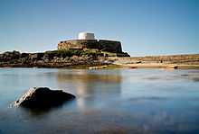
Fort Grey, colloquially known as the "cup and saucer", is a Martello tower located on a rock in Rocquaine Bay in Saint Peter, Guernsey. The French name of the rock upon which the tower was built is the Château de Rocquaine (Castle of Rocquaine); in Guernésiais Châté dé Rocquoïne. It was previously the site of local witches' Sabbaths.
The existing fort, with its white tower was originally built as a defence by the British in 1804 during the Napoleonic Wars, it was named after Charles Grey, 1st Earl Grey, who was Governor of Guernsey from 1797 to 1807.[1][2]

The Fort Grey tower, like the other two Guernsey Martello towers, Fort Saumarez and Fort Hommet, was intended as a keep for the battery in which it was placed. The Guernsey Martellos are smaller than the British towers, with the Fort Saumarez and Fort Hommet towers being smaller than the Fort Grey tower.[Note 1] Each mounted a 24-pounder carronade on the roof to protect the battery. Fort Saumarez and Fort Hommet also have exterior staircases up to the second floor.[4]
The War Office in London sold Fort Grey to the States of Guernsey in 1891 for £185. During the Occupation of the Channel Islands in World War II, the Germans occupied the fort, as they did most of the other fortifications in Guernsey.[2]
More recently Fort Grey has been adapted for other more peaceful uses and now operates as a local shipwreck museum, housing a number of items of marine salvage from famous wrecks, including the MV Prosperity and Elwood Mead. The items also include a cannon from HMS Boreas that points towards the nearby Hanois rocks where Boreas sank in 1807 with the loss of her captain, at least half her crew, and possibly the captain's wife.
Footnotes
- Notes
- Citations
- ↑ Ben Cahoon. "Guernsey". Worldstatesmen.org. Retrieved 2013-01-13.
- ↑ 2.0 2.1 http://www.museum.guernsey.net/download/Marie%20de%20Garis%20parish%20history%20extracts%20-%20SPDB.pdf
- ↑ Clements (1999), p.169.
- ↑ Clements (1999), p. 87.
References
- Clements, William H. (1998) Towers of Strength: Martello Towers Worldwide. (London: Pen & Sword). ISBN 978-0-85052-679-0.
- Dillon, Paddy (2011) Channel Island Walks. (Cicerone Guide). ISBN 1-85284-288-1
- Grimsley, E.J. (1988) The historical development of the Martello Tower in the Channel Islands. (Sarnian Publications). ISBN 978-0951386804
External links
- Fort Grey, Museums, Guernsey
- Governors of Guernsey
- History of St. Pierre du Bois by Marie de Garis 1995 PDF