Fordsdale, Queensland
| Fordsdale Queensland | |||||||||||||
|---|---|---|---|---|---|---|---|---|---|---|---|---|---|
|
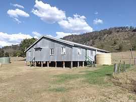
School of Arts hall, 2014 | |||||||||||||
 Fordsdale | |||||||||||||
| Coordinates | 27°43′10″S 152°7′15″E / 27.71944°S 152.12083°ECoordinates: 27°43′10″S 152°7′15″E / 27.71944°S 152.12083°E | ||||||||||||
| Population | 211 (2011)[1] | ||||||||||||
| Postcode(s) | 4343 | ||||||||||||
| LGA(s) | Lockyer Valley Region | ||||||||||||
| State electorate(s) | Lockyer | ||||||||||||
| Federal Division(s) | Wright | ||||||||||||
| |||||||||||||
Fordsdale is a locality in the Lockyer Valley Region of South East Queensland, Australia. At the 2011 Australian Census Forsdale and surrounds recorded a population 211.[1] The terrain in the area is rugged. Lower areas along the creeks have been farmed while the steep and elevated parts remain vegetated. Silky Oak Creek joins Ma Ma Creek, a tributary of Lockyer Creek at Fordsale. Dwyers Scrub Regional Park has been established in the west.
References
- ↑ 1.0 1.1 Australian Bureau of Statistics (31 October 2012). "Fordsdale (Gazetted Locality)". 2011 Census QuickStats. Retrieved 20 October 2014.
External links
![]() Media related to Fordsdale, Queensland at Wikimedia Commons
Media related to Fordsdale, Queensland at Wikimedia Commons
| ||||||||||