Folly Pier Waterworks

Folly Pier Waterworks was a Victorian waterworks on the Isle of Portland, Dorset, England. The building was situated near the coastline of East Weares, the east side of Portland, and sat below HM Prison Portland, which it supplied water for. The waterwork remains are of local historical interest for its association with the Portland Convict Establishment. The waterworks today only shows remains of the reservoirs foundations and walls, whilst the site itself is found close to various old historic relics such as the East Weares Rifle Range, Folly Pier, King's Pier, the Salt Pans and Little Beach. The East Weares area, including the site of the Folly Pier Waterworks, has been labelled a Site of Special Scientific Interest (SSSI), largely due to the scrub and wildlife being of high nature conservation value.[1]
History

With the continuous construction of the breakwaters for Portland Harbour, between 1849-72, as well as the various 19th-century fortifications including the Verne Citadel, a prison was established on the island to provide convict labour. Folly Pier Waterworks was constructed in 1855, purposely to serve HM Prison Portland at The Grove village directly above, which had opened in 1848. At a time before a piped water supply had been laid on the island, the increasing population the major government projects bought meant that the island's water supply, via wells and springs, quickly became inadequate. The waterworks ensured the prison was supplied, and the construction of this government building was overseen by Chief Engineer John Coode.[2] Coode was also responsible for the work on Portland Harbour's breakwaters along with many of its fortifications.
The waterworks was built south-west after Folly Pier, which it took its name from. The pier was created in the 18th and 19th century to transport stone by sea from the island.[3] The waterworks was built with separate reservoir tanks to hold rainwater and seawater, and these would both be pumped up to the prison. As the waterworks worked near Folly Pier, the close proximity between the two allowed small vessels to bring coal to land for the waterwork's pumper boiler.[4]
The site is marked on the Ordnance Survey maps of 1891 and 1903 as "Folly Pier Water Works (Prison Department)". A number of buildings, a retaining wall to the cliff edge, several small tanks, and a group of three reservoirs are depicted on these maps. A late 19th century or early 20th century photograph of the site details the layout and design of the principal buildings which included a pumping house, boiler house and a chimney. These were built of Portland stone under slate roofs. This photograph showing the waterwork's full operation has circulated in books and online in recent decades.[3][5] The waterworks was closed due to an outbreak of typhoid which killed several prisoners who drank the water.[3] The Portland Branch Railway would also run almost next to the waterworks once the Easton and Church Hope Railway was operational circa 1902.[3][6]
In 1921 the Portland convict establishment was converted into a Borstal and by this point the waterworks was largely destroyed. However during the late 1920s and 1930s, the remaining ruins of the reservoir tanks were used as swimming pools for Borstal Boys, despite the risk of Typhoid. They were first opened in 1927 for the Borstal Boys, where they took part in annual swimming galas until a new swimming pool was constructed within the perimeter wall.[7][8]
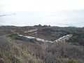
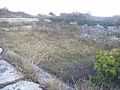
Nature has now nearly reclaimed her ground in East Weares as overgrown brambles surround the foundations. Beneath the foliage lie the low broken stone foundations and walls. The majority of the site, if not all of the waterworks buildings, have either been demolished or have collapsed in the intervening years. Only the stone foundations of some structures and the reservoirs, which have walls of Portland stone, are understood to survive under the overgrowth. In 1989, Geoff Kirby and his children, with the addition of shears and knives, cut away enough of the brambles to be able to trace the foundations. Since then the foundations today remain reachable, although foliage heavily surrounds the remains. One of the remaining reservoirs acts now as a pond, with reeds filling the area. The stonework of Folly Pier itself remains derelict as well today.[3]
In addition to the site, a World War II pillbox is located near the shoreline, north of Folly Pier Waterworks - and next to Folly Pier. This pillbox was constructed during 1940-41, of reinforced concrete and stone. It has an irregular six-sided plan. As with many of Portland's pillboxes and heavy anti-aircraft batteries, this structure would probably have been built by local quarrymen. An original field visit in 1996 had found the structure to be in good condition, and as of 2014 it remains in the same condition. However part of the cliff face has dropped, and the pillbox has become slightly overhanging, to which an inevitable collapse will occur in the future.[9]
Access
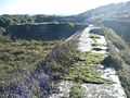
The waterworks foundations can be reached via an unofficial pathway veering off the official coastal path of the East Weares area. A similar pathway further south links to the Salt Pans of East Weares.
References
- ↑ "File:East Weares - Portland Goats Sign - Portland, Dorset.JPG - Wikimedia Commons". Commons.wikimedia.org. Retrieved 2013-12-04.
- ↑ Morris, Stuart (1985). Portland, an Illustrated History. Dorset: The Dovecote Press, Wimborne, Dorset. p. 87. ISBN 0-946159-34-3.
- ↑ 3.0 3.1 3.2 3.3 3.4 "East Weares Rifle Range and Waterworks, Portland, Dorset". Geoffkirby.co.uk. Retrieved 2013-12-04.
- ↑ Morris, Stuart (2006). Portland Then and Now. Dovecote Press. pp. Photo 10 of Portland Harbour Chapter. ISBN 978-1904349488.
- ↑ http://www.geoffkirby.co.uk/Portland/700725/70072503.jpg
- ↑ http://www.geoffkirby.co.uk/Portland/700725/70072502.jpg
- ↑ Legg, D. R. G. (2000). Portland Prison Illustrated. Sprint Signs and Graphics, Weymouth. p. 46.
- ↑ "Portland Prison illustrated 1848-2000 - D. R. G. Legg - Google Books". Books.google.co.uk. Retrieved 2013-12-04.
- ↑ http://www.pastscape.org.uk/hob.aspx?hob_id=1420397&sort=2&type=&typeselect=c&rational=a&class1=None&period=None&county=93347&district=93625&parish=93626&place=pillbox&recordsperpage=10&source=text&rtype=&rnumber=
Gallery
-
The waterworks from the coast path of East Weares.
-

A view of part of the overgrown area from the coast path.
-
A large section of the remains.
-

Another large section of the remains.
-
The centre area of the remains.
-

Reeds growing in a pond-like area of the ruins.
-

The same reeds of the pond.
-

A remaining wall.
-

Looking upwards to the cliff tops from the remains.
-

Looking upwards to the cliff tops again, with the foliage surrounding the ruins.
Coordinates: 50°33′13″N 2°25′07″W / 50.5535°N 2.4187°W
| ||||||||||||||||||||||||||||||||||||||||||||||||||||||||||||||||||