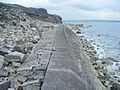
Folly Pier

Folly Pier is a stone shipping quay, located on the Isle of Portland, Dorset, England; part of the Jurassic Coast. It is found on the east side of the island within the area of East Weares - now abandoned.[1] Other features within the area includes King's Pier, East Weares Rifle Range, Folly Pier Waterworks, the two Salt Pans, Little Beach and Durdle Pier respectively.[2] Although Folly Pier, like many of the stone shipping quays on Portland, dates to the 17th century.[3] On the site of Folly Pier there is a tumbled pile of dressed stones at the edge of the sea.[4]
History
Folly Pier was once known as Old Pier. When British architect Inigo Jones chose Portland Stone for the rebuilding of the Banqueting House at Whitehall, London, in 1619, the island's stone became increasingly popular. The three-year contract between Jones and the island gave Portland the chance to build various roads, and also the piers along East Weares' coastline. Folly Pier was one of these, and became one of the main stone shipping places on the east side. With the establishment of the stone industry, quarry owners were given the right to erect piers with cranes for shipping stone from anywhere along the coastline.
The pier, during 1745, was described as being useless, and subject to be destroyed by the sea. In 1765, a new pier on the site had been built, recorded on a plan of 1770 as 'Mr Gilbert's Pier Commonly known by Folly.' In 1800 it was named as New or Folly Pier.[5] The name Folly originated from the fact that the pier's exposed position beneath East Weares, coupled with landward inaccessibility, quickly consigned the pier to history.[6]
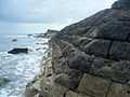
The limestone quarries of East and Penn's Weares were the earliest to be quarried on the island, and were the location of Sir Christopher Wren's first workings for stone to rebuild London after the Great Fire of 1666. The quarries occupied a 200-300m wide strip along the east coast of the island between Church Ope Cove and King's Pier. At Penn's Weare the dressing process remains clear and evident from roughly dressed stone to finely square blocks, with dressing rough-out piles in situ. These remains continue northwards into East Weare, although 19th and 20th century development has caused significant damage.[7] The stone was shipped from the adjacent Durdle, Folly, and King's Piers, although only Durdle Pier remained well-preserved until early 2014 when storms destroyed the pier's standing wooden crane.[8]
By the beginning of the 18th century Durdle Pier, King's Pier, as well as three piers situated around Church Ope Cove, had become well-established and favoured amongst Portland's piers. Folly Pier was not one of the most favoured piers, and similar piers were located around the island's rugged coast; near Freshwater Bay, Underbank near Southwell, as well as piers at West Weares, under West Cliff. However the latter proved to be briefly in use due to the unstable nature of the coastline, as well as a lack of roads. The best location for shipping stone was Castletown Pier, however it was situated far from the majority of the working quarries. The tracks from the quarries to the piers on the coastline were inadequate, and often impaired by heavy carts as well as landslides. If such a way was unable to be used, the neighbouring landowner was expected to allow quarry traffic to divert through their land, in return for Road Dues.[9]
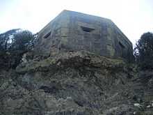
The surrounding area was chosen for the site of Folly Pier Waterworks, which was built in 1855 by John Coode for the government, to supply the prison with water. It was closed due to an outbreak of typhoid which killed several prisoners who drank the water, and the ruins of the reservoir tanks were used as swimming pools for Borstal Boys during the late 1920s and 1930s. The ruins still exist to date.[10][11] In addition to the pier and waterworks, a World War II pillbox is also located near the shoreline, next to pier. This pillbox was constructed during 1940-41, of reinforced concrete and stone. It has an irregular six-sided plan. As with many of Portland's pillboxes and heavy anti-aircraft batteries, this structure would probably have been built by local quarrymen. An original field visit in 1996 had found the structure to be in good condition, and as of 2014 it remains in the same condition. However part of the cliff face has dropped, and the pillbox has become slightly overhanging, to which an inevitable collapse will occur in the future.[12]
References
- ↑ http://www.geoffkirby.co.uk/Portland/700725/
- ↑ http://books.google.co.uk/books?id=GV3TISCxbSkC&pg=PR13&lpg=PR13&dq=king%27s+pier+portland&source=bl&ots=7aHeiivZMH&sig=oCsh-7EQlsN4KeXCsKyNYFKLmVw&hl=en&sa=X&ei=nWETU77LO4Wihgeb84GAAg&ved=0CFYQ6AEwCA#v=onepage&q=king%27s%20pier&f=false
- ↑ http://www.british-history.ac.uk/report.aspx?compid=127539
- ↑ http://www.british-history.ac.uk/report.aspx?compid=127539
- ↑ http://archaeologydataservice.ac.uk/archiveDS/archiveDownload?t=arch-804-1/dissemination/pdf/Isle_Of_Portland_Industrial_Archaeology_Survey_Report.pdf
- ↑ Legg, Rodney (1999). Portland Encyclopaedia. Dorset Publishing Company. p. 50. ISBN 978-0948699566.
- ↑ http://www.pastscape.org.uk/hob.aspx?hob_id=1466569
- ↑ http://www.pastscape.org.uk/hob.aspx?hob_id=453861
- ↑ Morris, Stuart (1985). Portland: An Illustrated History. Dovecote Press. p. 54. ISBN 978-0946159345.
- ↑ Legg, D. R. G. (2000). Portland Prison Illustrated. Sprint Signs and Graphics, Weymouth. p. 46.
- ↑ http://www.geoffkirby.co.uk/Portland/700725/
- ↑ http://www.pastscape.org.uk/hob.aspx?hob_id=1420397&sort=2&type=&typeselect=c&rational=a&class1=None&period=None&county=93347&district=93625&parish=93626&place=pillbox&recordsperpage=10&source=text&rtype=&rnumber=
Gallery


Coordinates: 50°33′12″N 2°25′03″W / 50.5533°N 2.4175°W
| ||||||||||||||||||||||||||||||||||||||||||||||||||||||||||||||||||