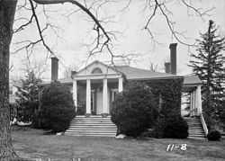
Folly (Staunton, Virginia)
|
Folly | |
 | |
 | |
| Location | South of Staunton on U.S. 11, near Staunton, Virginia |
|---|---|
| Coordinates | 38°05′21″N 79°06′05″W / 38.08917°N 79.10139°WCoordinates: 38°05′21″N 79°06′05″W / 38.08917°N 79.10139°W |
| Area | 570 acres (230 ha) |
| Built | c. 1818 |
| Architectural style | Early Republic, Jeffersonian Classicism |
| Governing body | Private |
| NRHP Reference # | 73001995[1] |
| VLR # | 007-0015 |
| Significant dates | |
| Added to NRHP | October 25, 1973 |
| Designated VLR | September 18, 1973[2] |
Folly is a historic plantation home located near Staunton, Augusta County, Virginia. The house was built about 1818, and is a one-story, brick structure with a long, low service wing and deck-on-hip roof in the Jeffersonian style. It has an original rear ell fronted by a Tuscan order colonnade. The front facade features a tetrastyle pedimented portico with stuccoed Tuscan columns and a simple lunette in the pediment. A similar portico is on the north side and a third portico was replaced by a wing added in 1856. The house closely resembles Edgemont near Covesville, Virginia. Also on the property are contributing original brick serpentine walls, a spring house, smokehouse and icehouse.[3]
It was listed on the National Register of Historic Places in 1973.[1]
References
- ↑ 1.0 1.1 "National Register Information System". National Register of Historic Places. National Park Service. 2010-07-09.
- ↑ "Virginia Landmarks Register". Virginia Department of Historic Resources. Retrieved 05-12-2013. Check date values in:
|accessdate=(help) - ↑ Virginia Historic Landmarks Commission Staff (August 1973). "National Register of Historic Places Inventory/Nomination: Folly". and Accompanying photo
External links
- Folly Farm, Folly Mills Creek, Staunton, Staunton, VA including 7 photos, 10 measured drawings, and 4 data pages at the Historic American Buildings Survey (HABS)

