Foley Island
 Foley Island, Nunavut. | |
| Geography | |
|---|---|
| Location | Foxe Basin |
| Coordinates | 68°30′N 75°00′W / 68.500°N 75.000°WCoordinates: 68°30′N 75°00′W / 68.500°N 75.000°W |
| Archipelago | Canadian Arctic Archipelago |
| Area | 637 km2 (246 sq mi) |
| Country | |
| Nunavut | Nunavut |
| Region | Qikiqtaaluk |
| Demographics | |
| Population | Uninhabited |
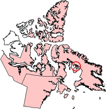
Foley Island is a low-lying Canadian arctic island located in Nunavut, Canada. It is along the southern coast of Baffin Island in the Foxe Basin and measures 637 km2 (246 sq mi) in area.[1]
The first written recording of the island's existence was in 1948, as were neighboring Prince Charles Island and Air Force Island, by a Royal Canadian Air Force crew member, Albert-Ernest Tomkinson, navigating an Avro Lancaster.
References
- ↑ "Foley Island". oceandots.com. Retrieved 2008-10-20.