Fleurieux-sur-l'Arbresle
| Fleurieux-sur-l'Arbresle | ||
|---|---|---|
|
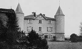
The château in Fleurieux-sur-l'Arbresle, at the beginning of the 20th century | ||
| ||
 Fleurieux-sur-l'Arbresle | ||
|
Location within Rhône-Alpes region  Fleurieux-sur-l'Arbresle | ||
| Coordinates: 45°50′13″N 4°39′12″E / 45.8369°N 4.6533°ECoordinates: 45°50′13″N 4°39′12″E / 45.8369°N 4.6533°E | ||
| Country | France | |
| Region | Rhône-Alpes | |
| Department | Rhône | |
| Arrondissement | Villefranche-sur-Saône | |
| Canton | L'Arbresle | |
| Intercommunality | Pays de L'Arbresle | |
| Government | ||
| • Mayor (2014–2020) | Diogène Batalla | |
| Area1 | 9.51 km2 (3.67 sq mi) | |
| Population (2011)2 | 2,335 | |
| • Density | 250/km2 (640/sq mi) | |
| INSEE/Postal code | 69086 / 69210 | |
| Elevation |
200–403 m (656–1,322 ft) (avg. 400 m or 1,300 ft) | |
|
1 French Land Register data, which excludes lakes, ponds, glaciers > 1 km² (0.386 sq mi or 247 acres) and river estuaries. 2 Population without double counting: residents of multiple communes (e.g., students and military personnel) only counted once. | ||
.svg.png)
Fleurieux-sur-l'Arbresle is a commune in the Rhône department in eastern France.
See also
References
| Wikimedia Commons has media related to Fleurieux-sur-l'Arbresle. |