Fleuriel
| Fleuriel | |
|---|---|
|
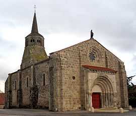
The church in Fleuriel | |
 Fleuriel | |
|
Location within Auvergne region  Fleuriel | |
| Coordinates: 46°16′57″N 3°10′44″E / 46.2825°N 3.1789°ECoordinates: 46°16′57″N 3°10′44″E / 46.2825°N 3.1789°E | |
| Country | France |
| Region | Auvergne |
| Department | Allier |
| Arrondissement | Moulins |
| Canton | Chantelle |
| Intercommunality | Pays Saint-Pourcinois |
| Government | |
| • Mayor (2008–2014) | Gérard Laplanche |
| Area1 | 28.05 km2 (10.83 sq mi) |
| Population (2008)2 | 358 |
| • Density | 13/km2 (33/sq mi) |
| INSEE/Postal code | 03115 / 03140 |
| Elevation |
255–446 m (837–1,463 ft) (avg. 430 m or 1,410 ft) |
|
1 French Land Register data, which excludes lakes, ponds, glaciers > 1 km² (0.386 sq mi or 247 acres) and river estuaries. 2 Population without double counting: residents of multiple communes (e.g., students and military personnel) only counted once. | |
Fleuriel is a commune in the Allier department in central France.
Population
| Historical population | ||
|---|---|---|
| Year | Pop. | ±% |
| 1962 | 331 | — |
| 1968 | 429 | +29.6% |
| 1975 | 335 | −21.9% |
| 1982 | 330 | −1.5% |
| 1990 | 330 | +0.0% |
| 1999 | 311 | −5.8% |
| 2008 | 358 | +15.1% |
See also
References
External links
| Wikimedia Commons has media related to Fleuriel. |
I