Fletcher Field
| Fletcher Field | |||||||||||
|---|---|---|---|---|---|---|---|---|---|---|---|
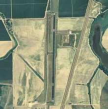
 USGS 2006 orthophoto | |||||||||||
| IATA: CKM – ICAO: KCKM – FAA LID: CKM | |||||||||||
| Summary | |||||||||||
| Airport type | Public | ||||||||||
| Owner | Coahoma County Airport Board | ||||||||||
| Serves | Clarksdale, Mississippi | ||||||||||
| Location | Coahoma County | ||||||||||
| Elevation AMSL | 173 ft / 53 m | ||||||||||
| Coordinates | 34°17′59″N 090°30′44″W / 34.29972°N 90.51222°WCoordinates: 34°17′59″N 090°30′44″W / 34.29972°N 90.51222°W | ||||||||||
| Map | |||||||||||
 CKM Location of airport in Mississippi | |||||||||||
| Runways | |||||||||||
| |||||||||||
| Statistics (2011) | |||||||||||
| |||||||||||
Fletcher Field[1][2][3] (IATA: CKM[4], ICAO: KCKM, FAA LID: CKM) is a public use airport in Coahoma County, Mississippi, United States.[1] It is owned by the Coahoma County Airport Board and located seven nautical miles (13 km) northeast of the central business district of Clarksdale, Mississippi.[1] This airport is included in the National Plan of Integrated Airport Systems for 2011–2015, which categorized it as a general aviation facility.[5] There is no scheduled commercial airline service.
Facilities and aircraft
Fletcher Field covers an area of 252 acres (102 ha) at an elevation of 173 feet (53 m) above mean sea level. It has one runway designated 18/36 with an asphalt surface measuring 5,404 by 100 feet (1,647 x 30 m).[1]
For the 12-month period ending November 8, 2011, the airport had 36,203 aircraft operations, an average of 99 per day: 99.8% general aviation and 0.2% military. At that time there were 18 aircraft based at this airport: 78% single-engine, 11% multi-engine, and 11% jet.[1]
History
Fletcher Field, was opened on July 5, 1942 and used by the United States Army Air Forces as a contract basic flying training airfield. It was operated by the 2154th Air Base Unit, Contract Elementary Flying School (AAFFTC), Clarksdale School of Aviation. Students were trained on Fairchild PT-23 and Boeing-Stearman PT-17 trainers. Known sub-bases and auxiliaries assigned to the field were:
- Clarksdale Auxiliary Field 31°11′40″N 090°33′01″W / 31.19444°N 90.55028°W
- Ellis Auxiliary Field (Undetermined Location)
It operated until October 14, 1944 when the last class graduated. The equipment and aircraft at the base were declared excess and sold in November. The airfield was then turned over to civil authorities as an airport. [6] [7] [8]
See also
- Mississippi World War II Army Airfields
- List of airports in Mississippi
- 29th Flying Training Wing (World War II)
References
- ↑ 1.0 1.1 1.2 1.3 1.4 1.5 FAA Airport Master Record for CKM – Fletcher Field (Form 5010 PDF). Federal Aviation Administration. Effective November 15, 2012.
- ↑ "Transportation: Fletcher Field". Clarksdale/Coahoma County Chamber of Commerce. Retrieved August 13, 2013.
- ↑ "Clarksdale Coahoma County Airport Day at Fletcher Field". Delta Bohemian. November 1, 2011.
- ↑ "IATA Airport Code Search (CKM: Fletcher Field)". International Air Transport Association. Retrieved August 13, 2013.
- ↑ "2011–2015 NPIAS Report, Appendix A" (PDF, 2.03 MB). National Plan of Integrated Airport Systems. Federal Aviation Administration. October 4, 2010.
- ↑
 This article incorporates public domain material from websites or documents of the Air Force Historical Research Agency.
 - ↑ Shaw, Frederick J. (2004), Locating Air Force Base Sites History’s Legacy, Air Force History and Museums Program, United States Air Force, Washington DC, 2004.
- ↑ Manning, Thomas A. (2005), History of Air Education and Training Command, 1942–2002. Office of History and Research, Headquarters, AETC, Randolph AFB, Texas ASIN: B000NYX3PC.
External links
- Fletcher Field at Clarksdale/Coahoma County Chamber of Commerce
- Aerial image as of January 1998 from USGS The National Map
- FAA Terminal Procedures for CKM, effective April 2, 2015
- Resources for this airport:
- FAA airport information for CKM
- AirNav airport information for CKM
- ASN accident history for CKM
- FlightAware airport information and live flight tracker
- SkyVector aeronautical chart for CKM
| ||||||||||||||||||
