Fjære
| Fjære kommune | |
|---|---|
| Former Municipality | |
|
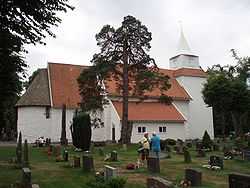
Fjære church | |
| Coordinates: 58°21′58″N 08°35′40″E / 58.36611°N 8.59444°ECoordinates: 58°21′58″N 08°35′40″E / 58.36611°N 8.59444°E | |
| Country | Norway |
| County | Aust-Agder |
| District | Sørlandet |
| Municipality ID | NO-0923 |
| Adm. Center | Fjære |
| Created from | Øyestad in 1846 |
| Merged with | Grimstad in 1971 |
Fjære is a former municipality in Aust-Agder county, Norway. Fjære municipality was located to the north of the town of Grimstad, and the name is still used to refer to that area, which is now a part of Grimstad.
Name
The municipality (originally the parish) of Fjære was named after the old Fjære farm (Old Norse: Fjǫrðr or Fjarðar), where the first church was built. The name is identical with the word fjǫrðr which means "fjord".[1]
History
The municipality of Fjære was created by a split from the neighboring municipality of Øyestad in 1846. At that time, Fjære had a population of 2,806. Part of Fjære with a population of 948 was transferred to the neighboring municipality of Grimstad on 1 January 1878. Again on 1 January 1960, another part of Fjære (population: 344) was transferred to Grimstad.
On 1 January 1971, the remainder of the municipality of Fjære was merged into the municipality of Grimstad along with the municipality of Landvik. Prior to the merger, Fjære had a population of 6,189.[2]
Fjære church
This church is made of stone and dates back to the middle of the 12th century. Despite being 850 years old, it is a living congregational church. It was not completed in one generation, but was created gradually over the centuries. The church grew together with the village and the people, and became the centre of Fjære's history from the Middle Ages until the present day. The oldest and most valuable individual cultural monuments in and around Fjære church are the finely sculpted head of a man in stone over the south door, dating from before 1150.
The church's unique and beautiful baptismal font, in the High Gothic style from the Middle Ages. Olavskilden, a fountain associated with St. Olav the Holy. The Terje Vigen stone monument in memory of the brave men of the 1807–1814 war. The stone monument was erected in 1906 by the friends of Terje Vigen. The altarpiece, pulpit with panelled ceiling and pews with the names of farms painted on them are consldered valuable. They were made in the period 1500–1700. The well preserved church is located approximately 3 kilometres (1.9 mi) north of Grimstad.[3]
References
- ↑ Rygh, Oluf (1905). Norske gaardnavne: Nedenes amt (in Norwegian) (8 ed.). Kristiania, Norge: W. C. Fabritius & sønners bogtrikkeri. p. 115.
- ↑ Jukvam, Dag (1999). "Historisk oversikt over endringer i kommune- og fylkesinndelingen" (PDF) (in Norwegian). Statistisk sentralbyrå.
- ↑ "Grimstad Municipality in Norway". GoNorway.com.
External links
 Aust-Agder travel guide from Wikivoyage
- Fjære school (Norwegian)
