Fitzroy River (Queensland)
| Fitzroy | |
| River | |
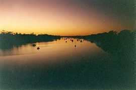 Dawn breaks on the Fitzroy River as it passes through Rockhampton | |
| Country | Australia |
|---|---|
| State | Queensland |
| Region | Central Queensland |
| City | Rockhampton |
| Source confluence | Dawson and Mackenzie rivers |
| - coordinates | 23°37′39″S 149°46′1″E / 23.62750°S 149.76694°E |
| Mouth | Pacific Ocean near Port Alma |
| - elevation | 0 m (0 ft) |
| - coordinates | 23°31′15″S 150°51′58″E / 23.52083°S 150.86611°ECoordinates: 23°31′15″S 150°51′58″E / 23.52083°S 150.86611°E |
| Length | 480 km (298 mi) |
| Basin | 142,665 km2 (55,083 sq mi) |
| Wikimedia Commons: Fitzroy River, Queensland | |
The Fitzroy River lies in Queensland, Australia. Its catchment covers an area of 142,665 square kilometres, making it the largest river catchment flowing to the eastern coast of Australia.[1] The river is formed by the joining of the Mackenzie and Dawson rivers at Duaringa.[2] The catchment stretches from the Carnarvon Ranges in the west to the rivermouth in Keppel Bay, near Rockhampton. It is bounded to the north by the Burdekin River catchment area and to the south by the Burnett River catchment area.
The Fitzroy was named by Charles and William Archer on 4 May 1853 in honour of Sir Charles FitzRoy, Governor of the Colony of New South Wales, as Queensland did not become a separate colony until 1859.
Settlement
The city of Rockhampton is situated 40 kilometres (25 mi) from the coast on the river. During the 19th and early 20th centuries, the city was a major port, however rocky bars in the river prevented the Fitzroy from being used for navigation any further inland. As ships became larger, the lower reaches became less viable for commercial traffic, and today only pleasure craft and small commercial fishing boats use the river. Wharves which once lined the town reach at Rockhampton have now almost all disintegrated or been removed. Predominant industries in the catchment are coal mining, grazing and cotton.
Nowadays, the river has a number of dams and weirs along its length. The Fitzroy Barrage at Rockhampton which can hold 61,000 ML when full,[2] provides fresh water to city and surrounds, while the Fairbairn Dam, on the Nogoa River (a tributary) and several weirs downstream on the Mackenzie River, provide water for irrigating a wide range of crops including cotton, peanuts, chickpea, corn and horticulture (citrus, table grapes, melons), supplying water for coal mines and domestic use for the town of Emerald.
Glenmore Homestead was built at a property on the northern bank of the river seven kilometres northwest of Rockhampton. It was originally settled in 1858, is listed on the Queensland Heritage Register and operates as a tourist attraction today.[3]
Wildlife
The lower reaches of the river are home to salt water crocodiles, a recently captured example (2003) being more than 4 metres long. The most diverse range of freshwater fish in the country are found within the Fitzroy basin.[2] The prized Australian fish, the barramundi, breeds in the river along with sooty grunter and a separate genetic strain of golden perch.[2]
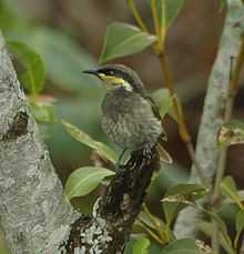
Some 987 km2 of the river's floodplain and delta have been classified by BirdLife International as the Fitzroy Floodplain and Delta Important Bird Area (IBA). It regularly supports over 1% of the world population of the sharp-tailed sandpiper as well as having a resident breeding population of the range-restricted mangrove honeyeater.[4]
At the mouth of the river researchers have discovered a genetically distinct snubfin dolphins species with a population of just 70 animals. The WWF believes planned coal port on Balaclava Island by Xstrata could wipe out the local snubfin population.[5]
2010–2011 Queensland floods
The Fitzroy river basin is one of a number that experienced extensive flooding during the 2010–2011 Queensland floods.
2013 Flood
Flash flooding in the Mount Morgan and Biloela regions brought major flooding to the lower Dawson River catchment. The Don river and the Dee River also rose to new record heights. The Fitzroy river at Rockhampton rose above major flooding to 8.61m.

Tributaries
Tributaries of the Fitzroy include the Mackenzie River with its tributaries the Nogoa River, Comet River, Isaac River and its tributary Connors River. The second major tributary is the Dawson River which has two tributaries, the Don River and Dee River.
See also
References
- ↑ Fitzroy Basin Association (2005) 'Central Queensland Strategy for Sustainability: 2004 and beyond', The Fitzroy Basin Association Inc., Rockhampton, Qld. ISBN 0-9758172-0-5
- ↑ 2.0 2.1 2.2 2.3 Harrison, Rod; Ernie James; Chris Sully; Bill Classon; Joy Eckermann (2008). Queensland Dams. Bayswater, Victoria: Australian Fishing Network. p. 157. ISBN 978-1-86513-134-4.
- ↑ "Glenmore Homestead (entry 15598)". Queensland Heritage Register. Queensland Heritage Council.
- ↑ "IBA: Fitzroy Floodplain and Delta". Birdata. Birds Australia. Retrieved 2011-06-20.
- ↑ "Coal port could wipe out dolphin pod: WWF". Sydney Morning Herald (Fairfax Media). 14 October 2011. Retrieved 9 November 2011.
- McDonald L. (1981) Rockhampton: A History of City and District, University of Queensland Press, St Lucia, Qld. ISBN 0-7022-1620-8
External links
| Wikimedia Commons has media related to Fitzroy River, Queensland. |
| ||||||||||||||||||||||||||||||||||||||||||||||||||||||||