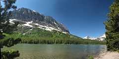
Fishercap Lake
| Fishercap Lake | |
|---|---|
 | |
| Location | Glacier National Park, Glacier County, Montana, US |
| Coordinates | 48°47′52″N 113°41′07″W / 48.79778°N 113.68528°WCoordinates: 48°47′52″N 113°41′07″W / 48.79778°N 113.68528°W[1] |
| Type | Natural |
| Primary inflows | Swiftcurrent Creek |
| Primary outflows | Swiftcurrent Creek |
| Basin countries | United States |
| Max. length | .20 miles (0.32 km) |
| Max. width | .10 miles (0.16 km) |
| Surface elevation | 4,944 ft (1,507 m) |
Fishercap Lake is located in Glacier National Park, in the U. S. state of Montana. Mount Wilbur is west of Fishercap Lake.[2] The lake is almost adjacent to the Swiftcurrent Auto Camp Historic District.
See also
List of lakes in Glacier County, Montana
References
- ↑ "Fishercap Lake". Geographic Names Information System. United States Geological Survey. Retrieved 2011-01-25.
- ↑ "Many Glacier, MT" (Map (USGS Quad)). TopoQuest. Retrieved 2011-01-25.