Firozpur district
| Firozpur district ਫ਼ਿਰੋਜ਼ਪੁਰ ਜ਼ਿਲ੍ਹਾ | |
|---|---|
| District | |
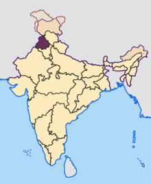
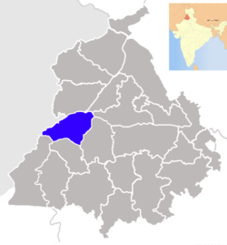 Location in Punjab, India | |
| Coordinates: 30°56′24″N 74°37′12″E / 30.94000°N 74.62000°ECoordinates: 30°56′24″N 74°37′12″E / 30.94000°N 74.62000°E | |
| Country |
|
| State | Punjab |
| Named for | Firoz Shah Tughlaq |
| Headquarters | Firozpur |
| Government | |
| • Deputy commissioner | D.P.S.Kharbanda |
| Area | |
| • Total | 5,305 km2 (2,048 sq mi) |
| Population (2011)‡[›] | |
| • Total | 2,029,074 |
| • Density | 380/km2 (990/sq mi) |
| Languages | |
| • Official | Punjabi |
| Time zone | IST (UTC+5:30) |
| Literacy | 69.80% |
| Website |
www |
Firozpur district (Punjabi: ਫ਼ਿਰੋਜ਼ਪੁਰ ਜ਼ਿਲ੍ਹਾ) is one of the twenty-two districts in the state of Punjab located in the North-West of the Republic of India. Firozpur district comprises an area of 5,305 km2 (2,048 sq miles). Prior to split of Firozpur district with the addition of Fazilka district, it comprised an area of 11,142 km2. The surface is level, with the exception of a few sand-hills in the south and south-east. The country consists of two distinct tracts that are liable to annual fertilizing inundations from the Sutlej, the only river, which runs along the north-western boundary. The principal crops are wheat, barley, millet, gram, pulses, oil seeds, cotton, and tobacco. The manufactures are of the humblest kind, consisting chiefly of cotton and wool-weaving and are confined entirely to the supply of local needs. The other important towns and areas of commerce are Zira, Dharmkot, Mallanwalla, Bharana and Talwandi Bhai. Owing principally to the dryness of its climate (apart from annual rains in July and August), Firozpur has the reputation of being an exceptionally healthy district. It has a large number of rice mills and used to be a big trading centre before the partition of India.
Firozpur is the capital city of the district. It is situated inside ten gates -- Amritsari Gate, Wansi Gate, Makhu Gate, Zira Gate, Bagdadi Gate, Mori Gate, Delhi Gate, Magjani Gate, Multani Gate and Kasuri Gate. The Firozpur City adjoining Firozpur Cantonment combines with the city to give the district its most urban hub. It is one of the oldest cantonments in India.
History
Firozpur District was part of the Mamdot estate. The capital city, Firozpur, is believed to have been founded by Firoz Shah Tughlaq from which the district obtains its name. In 1838, as part of the first Anglo-Afghan war, troops of the British East India Company marched from Firozpur to Kabul. Seven years later during the Anglo-Sikh War the area was the scene of conflict between the Khalsa army and the British. It has always remained an important place throughout its existence. It has always remained as a border area, earlier between the Sikhs and the British and now between India and Pakistan.[1]
Location and Geography
The district is located next to and shares its border with Pakistan, the international border being to its west. It has the district of Tarn Taran to its north across Sutluj. On the east of Firozpur lies the district of Moga and to its south it shares border with Faridkot district. On the southwest lies newly created Fazilka district. On the north and notheast it is separated from Tarn Taran and Kapurthala districts by Satluj River. The River Sutluj runs through the district and moves over to the Pakistan side through the India-Pakistan border. There is a large lake made at the Hussainiwala head works from where the original Gang Canal emanates. On the northern side of the river lies the famous Samadhi of Shaheed Bhagat Singh, Rajguru and Sahdev, the renowned martyrs of the freedom struggle.
Firozpur has extremes of climate, with the summers being very hot and the winters very cold.
Demographics
According to the 2011 census the undivided Firozpur district had a population of 2,026,831.[2][3] This gives it a ranking of 230th in India (out of a total of 640).[3] The district has a population density of 380 inhabitants per square kilometre (980/sq mi).[3] Its population growth rate over the decade 2001–2011 was 16.08%.[3] Firozpur has a sex ratio of 893 females for every 1000 males,[3] and a literacy rate of 69.8%.[3] (This data is before the creation of Fazilka district)
List of Villages in Firozpur
- Himatpura
- Sardarpura
- Jandwala Hanwanta
- Gumjal
- Chugha
- Nonari Khokhar
- Lopon
- Billimar
- Balel K Hasal
- Moranwala
- Sutantar Nagar
- Ugoke
- Sande Hasham
- Firoz Shah
- Bazidpur
- Mirzeke
- Dhandi Kadim
- Sekhwan
- Katora
- kaliawala
Administration
The district is administratively into the following tehsils:[2]
List of Sub-Tehsils of Firozpur
- Makhu
- Talwandi Bhai
- Mamdot
Blocks of District Firozpur
- Firozpur
- Ghall Khurd
- Guru Har Sahai
- Makhu
- Mamdot
- Zira
Vidhan Sabha Seats in Firozpur
- Firozpur
- Firozpur Rural
- Guru Har Sahai
- Zira
References
- ↑ History - Firozpur Online
- ↑ 2.0 2.1 Population - Firozpur Online
- ↑ 3.0 3.1 3.2 3.3 3.4 3.5 "District Census 2011". Census2011.co.in. 2011. Retrieved 2011-09-30.
External links
- FerozepurOnline.com (Ferozepur News, Ferozepur Weather, Find Anything in Ferozepur)
- "District Ferozepur". Retrieved 2007-10-18.
 |
Pakistan | Taran Taran district | Kapurthala district Jalandhar district |
|
| |
Moga district | |||
| ||||
| | ||||
| Fazilka district | Faridkot district |
| ||||||||||
| |||||||||||||||||||||||||