Finnish–Russian border
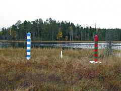
The Finnish–Russian border is the roughly north/south international border between Finland and Russia. Some 1,340 km (833 miles) long,[1] it runs mostly through uninhabited taiga forests and sparsely populated rural areas, not following any particular natural feature or river.[2] It is also part of the external border of both the Schengen Area and the European Union.
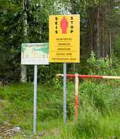
Border crossings are controlled and patrolled by the Finnish Border Guard and Border Guard Service of Russia, who also enforce border zones (0.1–3 km on the Finnish side,[3] 7.5 km on the Russian side). Entry to a border zone requires a permit. The electronic surveillance on the Finnish side is concentrated most heavily on the "southernmost 200 kilometers" and is constantly growing in sophistication.[4] Russia maintains its 500-year-old border patrol in the arctic region as elsewhere and plans to upgrade Soviet border technologies to both save on cost and to fully maximize the efficiency of the Border Service by the year 2020. But Lieutenant-General Vladimir Streltsov, deputy head of the Russian border service, noted that electronic surveillance will never replace the human element.[5]
The border can be crossed only at official checkpoints, and visas are required. Major border checkpoints are found in Vaalimaa and Nuijamaa, where customs services on both sides inspect and levy fees on imported goods.
The two endpoints of the border are a tripoint of Norway, Finland, and Russia (69°03′06″N 28°55′45″E / 69.05167°N 28.92917°E) in the north on Muotkavaara, and the shore of Gulf of Finland, in which there is a maritime boundary between the respective territorial waters, terminating in a narrow strip of international waters between Finnish and Estonian territorial waters.
History
The first border treaty on this border was signed in Nöteborg in 1323, between Sweden (to which Finland belonged) and the Novgorod Republic. The Treaty of Teusina moved the border eastbound. The Treaty of Nystad in 1721 and Treaty of Åbo in 1743 moved the border westbound. The Treaty of Fredrikshamn converted all of Finland from Swedish territory to a Russian possession. However the Finnish–Russian border was moved back to the pre-1721 location.
The Treaty of Tartu in 1920 defined Finland as independent and it defined the border. A demarcation was included in it. The land border was demarcated in the Treaty of Paris (1947) following the Continuation War (1941–44), in which Finnish Karelia and Petsamo were ceded to the Soviet Union. The naval border was established in 1940 and more accurately defined in 1965. The border is uncontroversial and clearly defined in law.[6] Both states verified the inviolability of borders and territorial integrity in the first Conference on Security and Co-operation in Europe in 1975.
List of border checkpoints
From north to south.
- Raja-Jooseppi (road 91 / P11)
- Salla (road 82)
- Lämsänkylä (road 866 / A136)
- Vartius (road 89)
- Vartius (Kontiomäki–Kostomuksha railway, freight only)
- Niirala / Vyartsilya (road 9 / A130)
- Imatra (road 62 / A124)
- Imatra (Imatra–Kamennogorsk railway, freight only)
- Nuijamaa (road 13 / A127)
- Vainikkala (Riihimäki – Saint Petersburg Railway, passenger and freight trains)
- Vaalimaa (road E18 / 7 / M10)
Passport stamps
The following are Finnish ink passport stamps applied at the Finnish–Russian border.
-
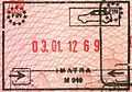
Passport entry stamp from the Finnish border checkpoint at Imatra
-
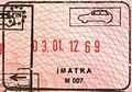
Passport exit stamp from the Finnish border checkpoint at Imatra
-
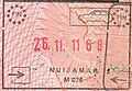
Passport entry stamp from the Finnish border checkpoint at Nuijamaa
-
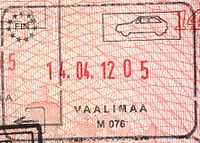
Passport exit stamp from the Finnish border checkpoint at Vaalimaa
-
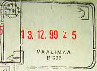
Passport exit stamp (old style) from the Finnish border checkpoint at Vaalimaa
References
- ↑ Grenfell, Julian; Jopling, Thomas Michael (2008). FRONTEX: the EU external borders agency, 9th report of session 2007-08. House of Lords Stationery Office. p. 13. ISBN 0-1040-1232-3.
- ↑ http://www.eudimensions.eu/content/pstudy/docs/FINLAND%20-%20RUSSIA%20Summary.pdf
- ↑ http://www.raja.fi/ohjeita/rajavyohyke
- ↑ "Electronic surveillance grows at Russian border as border guard strength is cut". HELSINGIN SANOMAT INTERNATIONAL EDITION - HOME. 6 October 2009. Retrieved 14 January 2014.
- ↑ Borisov, Timofey (28 May 2012). "Shpion v tsifrovom formate". Rossiyskaya Gazeta. Retrieved 27 March 2014.
- ↑ http://www.uta.fi/FAST/FIN/MIL/ps-surv.html
External links
| Wikimedia Commons has media related to Russia-Finland border. |
| ||||||