Fingerville, South Carolina
| Fingerville | |
|---|---|
| CDP | |
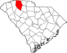
 Fingerville Location within the state of South Carolina | |
| Coordinates: 35°08′06″N 82°00′01″W / 35.13500°N 82.00028°WCoordinates: 35°08′06″N 82°00′01″W / 35.13500°N 82.00028°W | |
| Country | United States |
| State | South Carolina |
| County | Spartanburg |
| Area | |
| • Total | 0.152 sq mi (0.393 km2) |
| • Land | 0.152 sq mi (0.393 km2) |
| • Water | 0.000 sq mi (0.000 km2) |
| Population (2010) | |
| • Total | 134 |
| • Density | 880/sq mi (340/km2) |
| Time zone | Eastern (EST) (UTC-5) |
| • Summer (DST) | EDT (UTC-4) |
| ZIP codes | 29349 |
| FIPS code | 45083 |
Fingerville is a Census-designated place located in Spartanburg County in the U.S. State of South Carolina.[1] According to the 2010 United States Census, the population was 134.[2]
Geography
Fingerville is located at 35°08′06″N 82°00′01″W / 35.13500°N 82.00028°W (35.135077, -82.000409).[1] These coordinates place the CDP in the Northern part of the county.
According to the United States Census Bureau, the CDP has a total land area of 0.244 square miles (0.393 km²) and a total water area of 0.000 square miles (0.000 km²).[1]
References
- ↑ 1.0 1.1 1.2 "US Gazetteer files: 2010, 2000, and 1990". United States Census Bureau. 2011-02-12. Retrieved 2011-04-23.
- ↑ Source: 2010 Census results for Fingerville, SC
| |||||||||||||||||||||||||||||