Finchley Road
Finchley Road, an inner city main road which runs for about 7 kilometres (4.3 miles), is one of the major thoroughfares of north London, England.
Originally named Finchley New Road,[1] it was built as a turnpike road in the late 1820s/early 1830s to provide a by-pass to the existing route north from London through Hampstead. The Hampstead route (now the route Haverstock Hill, Rosslyn Hill and North End Road) contained two steep hills either side of Hampstead Village and was difficult for horses with carriages to negotiate when muddy.
The new turnpike was built at the same time as the improvements which created Regent's Park. It started from what was then called the 'New Road' (now Euston Road, Marylebone Road - the first London bypass) and ran north. As the road crossed the boundary of Finchley, its name became Regents Park Road, indicating the destination of the turnpike from Finchley. The turnpike ended when it joined the Great North Road as Ballards Lane.
There was a tollgate at Childs Hill. After construction, many grand houses were built along its length, especially near to what are now Fortune Green, Childs Hill and Golders Green. It was once served by Finchley Road railway station on the Midland Main Line, but that has long-sinced closed. It is still served by Finchley Road tube station and Finchley Road & Frognal railway station on the North London Line.
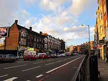
Today the route follows the A41 which becomes Finchley Road at St. John's Wood tube station. It goes north through Swiss Cottage, then turns slightly north west, forming the border between Hampstead and West Hampstead and then turns north again at Child's Hill. The A41 diverges westward and Finchley Road becomes the A598. It continues past Golders Green tube station, through Temple Fortune to the North Circular Road. The A598 continues north of the North Circular Road, but changes its name to Regents Park Road. It remains a heavily used route in and out of London. The most commercial part of the road is between Swiss Cottage tube station and the O2 Centre.