Filfla
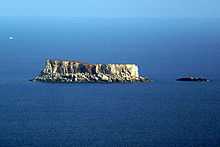 Filfla and neighboring Filfoletta seen from Dingli Cliffs (from northwest) | |
 Map of Filfla | |
| Geography | |
|---|---|
| Location | off Malta, south of Sicily, Mediterranean Sea |
| Coordinates | 35°47′15″N 14°24′37″E / 35.78750°N 14.41028°E |
| Archipelago | Maltese islands |
| Area | 0.06 km2 (0.023 sq mi) |
| Coastline | 800 m (2,600 ft) |
| Highest elevation | 60 m (200 ft) |
| Country | |
|
Malta | |
| Demographics | |
| Population | 0 |
| Filfla | |
|---|---|
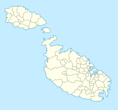 Location within Malta | |
| Coordinates: 35°47′15″N 14°24′37″E / 35.78750°N 14.41028°E |
Filfla is a small, barren, uninhabited islet 5 kilometres (3.1 miles) south of Malta, and is the most southerly point of the Maltese Archipelago. Filfoletta, a small rocky islet some 100 metres (328 feet) southwest of Filfla, has the southernmost point of Malta. The name is believed to come from filfel, the Arabic for a peppercorn.
Environment
Filfla has an area of just 6 hectares (15 acres) and is a crumbling flat-topped limestone plateau surrounded by 60 metres (197 feet) high cliffs. Three species of seabirds breed on the islet: the European storm petrel (with an estimated 5000 - 8000 pairs), Cory's shearwater (c. 200 pairs) and yellow-legged gull (c. 130 pairs). The island has been identified as an Important Bird Area (IBA) by BirdLife International, principally because of the storm petrel colony.[1] A type of wall lizard (Podarcis filfolensis ssp. filfolensis) and door snail (Lampedusa imitatrix gattoi) are endemic to Filfla. A large wild leek, growing up to 2 m (6 ft 7 in) high, also occurs. Access to Filfla is only possible for educational or scientific purposes and visitors must get prior permission from the Ministry responsible for the environment.
History
On the Maltese coast opposite Filfla are the archeological sites of Ħaġar Qim and Mnajdra, the Ħamrija Tower (one of 13 watchtowers that Martin de Redin built around the coast of Malta), and a memorial to Walter Norris Congreve, one of Malta's British governors, who was buried at sea in the channel between the island and Malta.
The only known permanent structure on the island was a chapel built inside a cave in 1343, which was destroyed by an earthquake in 1856 that also sank part of the island. A map of Malta dating back to 1798 shows a fort, a lighthouse and a monastery with a chapel on Filfla.[2]
Until 1971 the Royal Navy and Royal Air Force used the island for target practice. It became a bird reserve in 1980. The Filfla Natural Reserve Act, enacted in 1988, provided for further restrictions on access and use, including a prohibition on fishing within one nautical mile (1.9 km) around the island due to the possibility of encountering unexploded ordnance.
Maltese Government notice 173 of 1990 once again permitted fishing within the one mile zone.[3]
Filfla was invoked in a territorial dispute over the continental shelf between Libya and Malta. The case was adjudicated by the International Court of Justice in 1985 essentially by ignoring the islet from the calculations.[4][5]
See also
| Wikimedia Commons has media related to Filfla. |
References
- ↑ "Filfla Islet". Important Bird Areas factsheet. BirdLife International. 2013. Retrieved 2013-08-07.
- ↑ Dalli, Kim (28 April 2015). "‘Napoleon’ map gives a tantalising clue to the past". Times of Malta. Retrieved 29 April 2015.
- ↑ http://www.um.edu.mt/__data/assets/pdf_file/0006/43845/9..Marine_Protected_Areas_in_the_Maltese_Islands_1999.pdf
- ↑ Hance D. Smith (1991). The Development of Integrated Sea Use Management. Taylor & Francis. p. 82. ISBN 978-0-415-03816-4.
- ↑ CASE CONCERNING THE CONTINENTAL SHELF (LIBYAN ARAB JAMAHIRIYA/MALTA) Judgment of 3 June 1985
| ||||||||