Fianarantsoa
| Fianarantsoa | ||
|---|---|---|
|
Fianarantsoa | ||
| ||
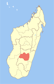
 Location of Fianarantsoa in Madagascar | ||
| Coordinates: 21°27′13″S 047°05′09″E / 21.45361°S 47.08583°ECoordinates: 21°27′13″S 047°05′09″E / 21.45361°S 47.08583°E | ||
| Country |
| |
| Founded | 1830 | |
| Elevation | 1,200 m (3,900 ft) | |
| Population (2009 census) | ||
| • Total | 160,550 | |
| Time zone | East African Time (GMT+3) | |

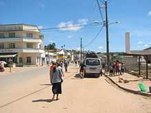
Fianarantsoa is a city (commune urbaine) in south central Madagascar.
Fianarantsoa is the capital of Haute Matsiatra Region. It was built in the early 19th century by the Merina as the administrative capital for the newly conquered Betsileo kingdoms.
It is at an average altitude of 1,200 metres (3,900 ft), and has a population of 144,225 (2001 census).
Fianarantsoa means "Good education" in Malagasy. It is a cultural and intellectual center for the whole island. It is home to some of the oldest Protestant and Lutheran cathedrals on the island, the oldest theological seminary (also Lutheran), as well as the Roman Catholic Archdiocese of Fianarantsoa. The city of "good education" also boasts a university named after it and built in 1972. Fianarantsoa is considered to be the capital of wine in Madagascar, because of the presence of many wine industries in the city.
Fianarantsoa has been known for its political activism and was one of the "hot spots" during the political crisis in 2002. Students of the University of Fianarantsoa have a reputation for sympathizing with radical leftist groups. The mayor of Fianarantsoa comes from the MFM political party whose colors are based on the anarcho-syndicalist flag.
Fianarantsoa was placed by the World Monuments Fund on its 2008 Watch List of the 100 Most Endangered Sites because many of the buildings in the old town are in dire need of repair. Fortunately, most of the repairs are relatively easy, and WMF hopes that the listing will attract attention to fund the necessary repairs to keep the old town looking beautiful.
Climate
Köppen-Geiger climate classification system classifies its climate as subtropical highland (Cwb).[1]
| Climate data for Fianarantsoa | |||||||||||||
|---|---|---|---|---|---|---|---|---|---|---|---|---|---|
| Month | Jan | Feb | Mar | Apr | May | Jun | Jul | Aug | Sep | Oct | Nov | Dec | Year |
| Average high °C (°F) | 26.2 (79.2) |
26.1 (79) |
25.3 (77.5) |
24.5 (76.1) |
22.6 (72.7) |
20.4 (68.7) |
19.7 (67.5) |
20.4 (68.7) |
23.0 (73.4) |
25.0 (77) |
26.1 (79) |
26.3 (79.3) |
23.8 (74.8) |
| Daily mean °C (°F) | 20.8 (69.4) |
20.8 (69.4) |
20.0 (68) |
18.9 (66) |
16.7 (62.1) |
14.5 (58.1) |
14.0 (57.2) |
14.4 (57.9) |
16.2 (61.2) |
18.3 (64.9) |
19.7 (67.5) |
20.4 (68.7) |
17.9 (64.2) |
| Average low °C (°F) | 17.2 (63) |
17.2 (63) |
16.5 (61.7) |
15.2 (59.4) |
12.7 (54.9) |
10.5 (50.9) |
10.1 (50.2) |
10.2 (50.4) |
11.2 (52.2) |
13.4 (56.1) |
15.3 (59.5) |
16.6 (61.9) |
13.8 (56.8) |
| Average precipitation mm (inches) | 227.8 (8.969) |
220.8 (8.693) |
137.6 (5.417) |
46.4 (1.827) |
27.3 (1.075) |
16.5 (0.65) |
24.6 (0.969) |
21.4 (0.843) |
18.0 (0.709) |
61.5 (2.421) |
124.9 (4.917) |
241.4 (9.504) |
1,168.2 (45.992) |
| Avg. precipitation days (≥ 1.0 mm) | 15 | 14 | 13 | 7 | 5 | 5 | 6 | 6 | 3 | 6 | 11 | 16 | 107 |
| Mean monthly sunshine hours | 191.1 | 171.0 | 175.4 | 184.8 | 186.0 | 165.9 | 163.5 | 191.1 | 220.5 | 230.4 | 208.0 | 190.1 | 2,277.8 |
| Source: NOAA[2] | |||||||||||||
Transports
The city is at the endpoint of the Fianarantsoa-Côte Est Railway. There is also an airport.
References
- ↑ "Climate: Fianarantsoa - Climate graph, Temperature graph, Climate table". Climate-Data.org. Retrieved 2014-02-01.
- ↑ "Fianarantsoa Climate Normals 1961–1990". National Oceanic and Atmospheric Administration. Retrieved March 8, 2015.
External links
| Wikivoyage has a travel guide for Fianarantsoa. |
![]() Media related to Fianarantsoa at Wikimedia Commons
Media related to Fianarantsoa at Wikimedia Commons


