Feteira (Horta)
| Feteira | |
| Civil Parish | |
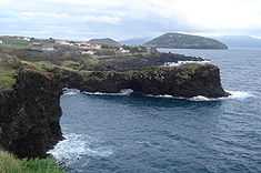 The coast of Feteira, showing the rocky cliffs and vista of Monte da Guia (to the east), Faial Island | |
| Official name: Freguesia de Feteira | |
| Name origin: feto, Portuguese for fern | |
| Country | |
|---|---|
| Autonomous Region | |
| Island | Faial |
| Municipality | Horta |
| Civil Parish | Feteira, Granja, Portela |
| River | Ribeira da Granja |
| Center | Feteira |
| - coordinates | 38°31′36″N 28°40′33″W / 38.52667°N 28.67583°WCoordinates: 38°31′36″N 28°40′33″W / 38.52667°N 28.67583°W |
| Highest point | Cangueira |
| - location | Serra de Feteira |
| - elevation | 737 m (2,418 ft) |
| - coordinates | 38°33′40″N 28°41′52″W / 38.56111°N 28.69778°W |
| Lowest point | Sea level |
| - location | Atlantic Ocean |
| - elevation | 0 m (0 ft) |
| Area | 14.46 km2 (6 sq mi) |
| - urban | 1.0 km2 (0 sq mi) |
| Population | 1,899 (2011) |
| Density | 131 / km2 (339 / sq mi) |
| Settlement | fl. 1562 |
| - Parish | 30 June 1568 |
| LAU | Junta Freguesia |
| - location | Estrada Regional |
| - coordinates | 38°38′4″N 24°41′46″W / 38.63444°N 24.69611°W |
| President Junta | Eduardo Humberto Silveira Pereira |
| President Assembleia | Conceição Maria Stattmiller S.S. Machado Lourenço |
| Timezone | Azores (UTC-1) |
| - summer (DST) | Azores (UTC0) |
| Postal Zone | 9500-361 |
| Area Code & Prefix | (+351) 292 XX XX XX |
| Demonym | Feteirense |
| Patron Saint | Divino Espírito Santo |
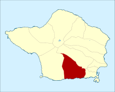 Location of the civil parish of Feteira within the municipality of Horta
| |
| Wikimedia Commons: Feteira | |
| Website: http://www.feteira.com/ | |
| Geographic detail from CAOP (2010)[1]produced by Instituto Geográfico Português (IGP) | |
Feteira is a civil parish in the southern part of the municipality of Horta, on the island of Faial in the Portuguese archipelago of the Azores. The population in 2011 was 1,899,[2] in an area of 14.46 km².[3] It occupies the southern foothills of the Cabeço Gordo, along the coast. The name Feteira is derived from the Portuguese word for "fern", and indicates a "location of [many] ferns"; the name likely refers to the original colonists discovery of this area covered with ferns.
History
The early inhabitants colonized the area around Ribeira da Granja, along the coast near Lajinha and Ponta Furada. They built their first community along the coast, although on higher ground.
The Church of Feteira, consecrated in honour of the Holy Spirit, is one of the older churches on the island. Although lost to history, its date of construction is currently unknown, although the first references to the sanctuary refers to 1562, when the local residents were forced to pay higher taxes to the parish. On June 30, 1568, King D. Sebastião passed a provision in favor of Feteira, related to new monies to support the parish, resolving the ongoing problems with funds. The historian Gaspar Frutuoso, referred to a church of three naves, supported by five columns and wood, with arterial chapels on either side. It was a temple of good proportions (35 m in width) with single bell-tower and nearby a 15th Century chapel. In 1597, it was sacked and burned by English pirates. The nearby chapel, of São Pedro, had been a place of pilgrimage during religious festivals, but, due to lack of attention and care, it was slowly abandoned.
Because of a history of piracy, the coast was monitored by small fort outposts: remnants of these forts have long since disappeared from the coast.
Geography
It is located 5 kilometres (3.1 mi) west of the city of Horta, connected by the southern extension of the Regional Road E.R.1-1ª in the south and a northern municipal road closer to the interior. Farmlands dominate the coastal plain between the parishes of Angústias and Castelo Branco, and the coast is a rugged area mostly undercut by the Atlantic Ocean. There are several rivers and streams that bisect the parish that have supported the populations growth and agriculture over the decades. It is known for five bridges: São Pedro, Porceirão, Igreja, a second one in São Pedro (at the lower part of the parish) and Ponte Nova.
Economy
Agriculture is the primary source of income. Historically, the parish has cultivated potatoes, supported orange and lemon orchards, as well as large quantities of wheat and corn. Documents for 1886 indicate a cultivation of 200,000 kilograms (440,000 lb) of potatoes. Most of these crops were cultivated for export, although small itinerant banana fields were cultivated for local consumption. These continue to important crops, but currently, the cattle and dairy industry is generally accepted as the primary source of agro-business (although some lambs are raised).
The fishery and paper industries have also supported the local economy. Yet, economic difficulties, in particular regional politics, have seen a decrease in people participating in these activities, since 1862.
Culture
There are approximately 37 impérios or religious structures to honour the Holy Spirit on the island, of these seven are located in the civil parish. Some, like the Império das Grotas in Feteira, date back to the 19th century (1898 specifically), have been susceptible to a change in the islands demographics, economics and agnosticism, and slowly abandoned due to local disinterest.[4]
References
- ↑ IGP, ed. (2010), Carta Administrativa Oficial de Portugal (in Portuguese), Lisbon, Portugal: Instituto Geográfico Português, retrieved 1 July 2011
- ↑ Instituto Nacional de Estatística
- ↑ Eurostat
- ↑ Silva, Maria José (27 March 2012), Império das Grotas pode não fazer festa este ano (in Portuguese), Horta (Azores), Portugal: Tribuna das Ilhas
| ||||||||