Ferriere
This article is about the Italian commune, for the Bordeaux Third growth see Château Ferriere
| Ferriere | |
|---|---|
| Comune | |
| Comune di Ferriere | |
 Ferriere Location of Ferriere in Italy | |
| Coordinates: 44°39′N 9°30′E / 44.650°N 9.500°ECoordinates: 44°39′N 9°30′E / 44.650°N 9.500°E | |
| Country | Italy |
| Region | Emilia-Romagna |
| Province | Piacenza (PC) |
| Frazioni | Brugneto, Canadello, Casaldonato, Cassimoreno, Castagnola Castelcanafurone,San Gregorio, Cattaragna, Ciregna, Gambaro, Grondone Pertuso, Rocca, Rompeggio, Salsominore, Selva, Torrio, Solaro |
| Area | |
| • Total | 179.5 km2 (69.3 sq mi) |
| Elevation | 626 m (2,054 ft) |
| Population (Dec. 2004)[1] | |
| • Total | 1,823 |
| • Density | 10/km2 (26/sq mi) |
| Demonym | Ferrieresi |
| Time zone | CET (UTC+1) |
| • Summer (DST) | CEST (UTC+2) |
| Postal code | 29024 |
| Dialing code | 0523 |
Ferriere (Piacentine: Al Frér) is a comune (municipality) in the Province of Piacenza in the Italian region Emilia-Romagna, located about 150 kilometres (93 mi) west of Bologna and about 45 kilometres (28 mi) southwest of Piacenza, in the Val Nure of the Ligurian Appennines.
Ferriere borders the following municipalities: Bardi, Bedonia, Cerignale, Coli, Corte Brugnatella, Farini, Ottone, Rezzoaglio, Santo Stefano d'Aveto.
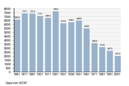
Demographic evolution