Fernando Luis Ribas Dominicci Airport
| Fernando Luis Ribas Dominicci Airport Isla Grande Airport Aeropuerto Isla Grande | |||||||||||
|---|---|---|---|---|---|---|---|---|---|---|---|
 | |||||||||||
| IATA: SIG – ICAO: TJIG – FAA LID: SIG | |||||||||||
| Summary | |||||||||||
| Airport type | Public | ||||||||||
| Owner | Puerto Rico Ports Authority | ||||||||||
| Serves | San Juan, Puerto Rico | ||||||||||
| Location | Miramar, Puerto Rico | ||||||||||
| Elevation AMSL | 9 ft / 3 m | ||||||||||
| Coordinates | 18°27′24″N 066°05′54″W / 18.45667°N 66.09833°WCoordinates: 18°27′24″N 066°05′54″W / 18.45667°N 66.09833°W | ||||||||||
| Map | |||||||||||
 SIG Location of airport in Puerto Rico | |||||||||||
| Runways | |||||||||||
| |||||||||||
| Statistics (2010) | |||||||||||
| |||||||||||
|
Source: Federal Aviation Administration[1] Operations from the FAA[2] Passengers from the Puerto Rico Ports Authority | |||||||||||
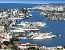
Fernando Luis Ribas Dominicci Airport (IATA: SIG, ICAO: TJIG, FAA LID: SIG), also commonly known as Isla Grande Airport, is a small airport in Miramar, which is a district in the municipality of San Juan, Puerto Rico. It is owned by the Puerto Rico Ports Authority[1] and is adjacent to the new Puerto Rico Convention Center, the San Juan Bay, and the Pan American Cruise Ship Terminal, and overlooks Cataño. While Isla Grande's main operation is with general aviation, it is still a commercial airport, dealing with some domestic and international commercial flights.
As per Federal Aviation Administration records, the airport had 13,837 passenger boardings (enplanements) in calendar year 2008,[3] 23,083 enplanements in 2009, and 38,363 in 2010.[4] It is included in the National Plan of Integrated Airport Systems for 2011–2015, which categorized it as a primary commercial service airport (more than 10,000 enplanements per year).[5]
History
Originally constructed by the U.S. Navy as Naval Air Station Isla Grande just prior to World War II,[6] the facility also served as Puerto Rico's main international airport until 1954, when Luis Muñoz Marín International Airport was built. Until that year, international airlines such as Deutsche Luft Hansa, Iberia Airlines, Pan Am and other majors flew to Isla Grande. However, since Isla Grande airport was not built to accept jets, all international airlines then moved their operations in Puerto Rico to Luis Muñoz Marín International Airport, then named Isla Verde International Airport.
Until 1971, the airport also hosted Coast Guard Air Station San Juan. That year, the Coast Guard relocated its air station to Ramey Air Force Base on Puerto Rico's northwest coast.
Isla Grande was renamed in honor of United States Air Force Major Fernando Luis Ribas-Dominicci, an F-111 pilot who was killed in action during Operation El Dorado Canyon; the 1986 airstrike of Libya.
A controversy regarding Isla Grande and Dorado Airport surfaced in 2003. Dorado Airport wanted to expand and attract the private aviation sector that has been Isla Grande's main business for so long. Dorado airport eventually became a victim of urban development in Dorado and no longer exists.
On October 26, 2003, the airport made history by becoming the first Puerto Rican site of a SCCA Grand Prix race.
In 2006, after a detailed impact study and many rumors about the future of the airport, the Puerto Rico Ports Authority announced that Isla Grande airport would remain open for the foreseeable future, mostly because of its key function as the primary reliever for the Luis Muñoz Marín International Airport.[7]
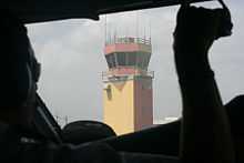
On August 4, 2011 the FAA announced that they were planning to close the airport's control tower due to budget cuts, since they operate it instead of the Puerto Rico Ports Authority.
On July 8, 2012 airport officials denied via written communication to a local newspaper of "any plans to eliminate or privatize the airport, since the airport is one of the most important airports for general aviation on Puerto Rico, taking into account that its operation approximates around 300 daily operations." On that same newspaper it was published that Seaborne Airlines would transition its operations to the neighboring Luis Muñoz Marin Intl Airport with complete pullout on January 16, 2013.[8]
Facilities and aircraft
Fernando Luis Ribas Dominicci Airport covers an area of 102 acres (41 ha) at an elevation of 9 feet (3 m) above mean sea level. It has one runway designated 9/27 with an asphalt surface measuring 5,542 by 100 feet (1,689 x 30 m).[1]
For the 12-month period ending September 30, 2013, the airport had 116,447 aircraft operations, an average of 319 per day: 92% general aviation, 6% air taxi, and 2% military. At that time there were 232 aircraft based at this airport: 33% single-engine, 37% multi-engine, 1% jet, 24% helicopter, and 6% military.[1]
Airlines and destinations
The following airlines offer scheduled passenger service at this airport:
| Airlines | Destinations |
|---|---|
| Air Flamenco | Culebra, Vieques, St. Croix, St. Thomas |
| Vieques Air Link | Culebra, Vieques |
Charter destinations
| Airlines | Destinations |
|---|---|
| M&N Aviation | La Romana, Punta Cana, Santiago de los Caballeros, Santo Domingo, Vieques |
Statistics
| Carrier | Passengers (arriving and departing) |
|---|---|
| Seaborne | 44,780(71.91%) |
| Vieques | 17,500(28.09%) |
| Rank | City | Airport | Passengers |
|---|---|---|---|
| 1 | Christiansted, VI (St. Croix) | Henry E. Rohlsen Airport (STX) | 11,000 |
| 2 | Charlotte Amalie, VI (St. Thomas) | Cyril E. King Airport (STT) | 11,000 |
| 3 | Vieques, PR | Antonio Rivera Rodríguez Airport (VQS) | 9,000 |
Army National Guard Aviation Support Facility
The Puerto Rico Army National Guard Aviation Support Facility is the only military site on Fernando Luis Ribas Dominicci Airport. Its mission is to support the Puerto Rico Army National Guard Aviation Units and U.S. Army South operations in the caribbean. Some of the military aircraft at this facility are the UH72 Lakota and the UH-60 Blackhawk helicopters.
Incidents
- On April 11, 1952 Pan Am Flight 526A crashed into the sea just after take off due to engine failure, killing 52 out of 69 passengers and crew.
- On December 21, 1991, a United Airlines Boeing 757 flight en route to San Juan's Luis Muñoz Marín International Airport mistakenly landed at Fernando Luis Ribas Dominicci Airport.
- June 7, 1992: An Executive Air (for American Eagle) CASA 212 flying from Dominicci Airport crashed short of the runway in Mayagüez, killing both crew members and all three passengers.[10]
- In December 2002, a helicopter that had been rented from a company that operates out of this airport was hijacked and taken to a jail in Ponce, where six inmates boarded the helicopter, forcing the pilot to drop them off at a farm. The pilot was able to fly back after he lied to the prisoners about their whereabouts, making them jump off the helicopter and zig-zagging the helicopter to prevent them from shooting at him. Soon after, all escapees were found by the police.
References
- ↑ 1.0 1.1 1.2 1.3 FAA Airport Master Record for SIG (Form 5010 PDF). Federal Aviation Administration. Effective April 5, 2012.
- ↑ Air Traffic Activity System
- ↑ "Enplanements for CY 2008" (PDF, 1.0 MB). CY 2008 Passenger Boarding and All-Cargo Data. Federal Aviation Administration. December 18, 2009.
- ↑ "Enplanements for CY 2010" (PDF, 189 KB). CY 2010 Passenger Boarding and All-Cargo Data. Federal Aviation Administration. October 4, 2011.
- ↑ "2011–2015 NPIAS Report, Appendix A" (PDF, 2.03 MB). National Plan of Integrated Airport Systems. Federal Aviation Administration. October 4, 2010.
- ↑ http://www.history.navy.mil/library/online/buildbaseswwii/bbwwii2.htm
- ↑ "Historic Puerto Rico GA Airport Saved! Isla Grande Economic Analysis Sways Politicos". Aero-News Network. July 18, 2006.
- ↑ "Niegan el cierre del Aeropuerto de Isla Grande, Vocero de Puerto Rico July 8, 2012.
- ↑ 9.0 9.1 "San Juan, PR: Isla Grande (SIG)". Bureau of Transportation Statistics (BTS), Research and Innovative Technology Administration (RITA), U.S. Department of Transportation. February 2012. Retrieved June 13, 2012.
- ↑ aviation-safety.net
External links
- Isla Grande Flying School
- www.globalsecurity.org/military/facility/isla-grande
- FAA Airport Diagram (PDF), effective April 30, 2015
- FAA Terminal Procedures for SIG, effective April 30, 2015
- Resources for this airport:
- FAA airport information for SIG
- AirNav airport information for TJIG
- ASN accident history for SIG
- FlightAware airport information and live flight tracker
- NOAA/NWS latest weather observations for TJIG
- SkyVector aeronautical chart for SIG
| ||||||||||||||||
